
アレクサンドリア (ルイジアナ州)
| アレクサンドリア市 City of Alexandria | |
|---|---|
 アレクサンドリアのダウンタウン | |
| 位置 | |
 右: ルイジアナ州におけるラピッズ郡の位置 左: ラピッズ郡におけるアレクサンドリアの市域 | |
| 座標 : 北緯31度18分44秒 西経92度26分45秒 / 北緯31.31222度 西経92.44583度 | |
| 歴史 | |
| 創設 | 1805年 |
| 行政 | |
| 国 | |
| 州 | ルイジアナ州 |
| 郡 | ラピッズ郡 |
| 市 | アレクサンドリア市 |
| 地理 | |
| 面積 | |
| 市域 | 69.9 km2 (27.0 mi2) |
| 陸上 | 68.4 km2 (26.4 mi2) |
| 水面 | 1.5 km2 (0.6 mi2) |
| 標高 | 23 m (75 ft) |
| 人口 | |
| 人口 | (2010年現在) |
| 市域 | 47,723人 |
| 人口密度 | 697.7人/km2(1,807.7人/mi2) |
| 都市圏 | 153,922人 |
| その他 | |
| 等時帯 | 中部標準時 (UTC-6) |
| 夏時間 | 中部夏時間 (UTC-5) |
| 公式ウェブサイト : https://www.cityofalexandriala.com/ | |
アレクサンドリア︵Alexandria [ælɪgˈzændriə]︶は、アメリカ合衆国ルイジアナ州中央部に位置する都市。州都バトンルージュの北西約170kmに位置する。州の地理重心の近くに位置し、市域はレッド川の南西岸に広がっている。人口は47,723人︵2010年国勢調査︶[1]で州内第10位、人口の比較的希薄な州中央部では最大で、その中心となる都市である。都市圏はアレクサンドリアに郡庁を置くラピッズ郡、およびその北に隣接するグラント郡の2郡にまたがり、153,922人︵2010年国勢調査︶[1]の人口を抱えている。
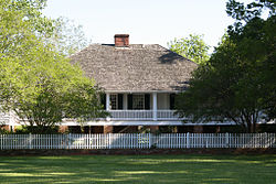
ケント・プランテーション・ハウス。1800年に建てられた州中部最 古のプランテーションで、1971年に国家歴史登録財に登録された[2][3]。現在は博物館になっている。
今日のアレクサンドリア市があるこの地は、1785年に、ペンシルベニア州出身の商人アレクサンダー・フルトンが、当時ルイジアナを統治していたスペインから付与された土地であった。その後フルトンは自分の店を通じて、この地に住みついていたネイティブ・アメリカンのチョクトー族、テンサス族、アパラチー族、およびパスカグーラ族から土地を購入した。やがてアメリカ合衆国によるルイジアナ買収後の1805年、フルトンはアレクサンドリアの町を創設し、区画した。このアレクサンドリアという名の由来については、フルトン自身に因んだとする説と、フルトンが幼くして亡くした娘の名に因んだとする説がある[2][4]。
アレクサンドリアは1819年に正式な町として法人化し、1832年にルイジアナ州議会から正式な憲章を与えられた[2][5]。アレクサンドリアのすぐ上流にはレッド川の滝があり、1年の半分はこの滝を越えての航行が不能となるため、アレクサンドリアは船荷の積み替え地となった[2]。また、周辺の土地は肥沃で、アレクサンドリアはプランテーションに囲まれていた。こうした立地条件から、この頃のアレクサンドリアは農業と商業の中心地として発展した。当初は、これらのプランテーションでは藍やタバコが生産されていたが、やがて綿花やサトウキビに取って代わられていった。1860年には、ルイジアナ州は全米で生産される綿花の約1/6、アメリカ合衆国から︵主にイギリスやフランスへ︶輸出される綿花の約1/3を、また全米で消費される砂糖の約1/4-1/2を生産した[6]。

ベイリーの堰
南北戦争中期の1863年春、北軍のナサニエル・バンクス少将率いるメキシコ湾岸軍がレッド川流域を北上し、同年5月9日にアレクサンドリアを占領した[7]。その後、バンクスはアレクサンドリアからミシシッピ川沿いのポートハドソンの要塞へと進軍し、包囲戦を戦った後、翌1864年3月にレッド川方面作戦で再びアレクサンドリアを占領した。バンクスは、今度は南軍ミシシッピ川流域管区の本部、および臨時のルイジアナ州都が置かれ、この作戦における標的になっていたシュリーブポートに向けて北西へと進軍した。しかし、バンクスはシュリーブポートの南、マンスフィールドの戦いで大敗を喫し、シュリーブポートを攻略することなく、プレザントヒルからアレクサンドリアへと逃げ帰った。その頃アレクサンドリアでは、レッド川の水位低下のために、滝の上で北軍海軍のデイビッド・ディクソン・ポーター提督の艦隊が立ち往生していたが、工兵のジョセフ・ベイリー中佐が堰を築いて水位を上げ、艦隊を逃がすことに成功した[2]。やがて同年5月14日、北軍はアレクサンドリアから撤退したが、その際に町に火を放った。この焼き討ちにより、アレクサンドリアの町の90%が焼失し、聖フランシス・ザビエル大聖堂を除いて全ての建物が焼失した。町の憲章もこの時に焼失したため、終戦後、1868年9月29日に、ルイジアナ州議会はアレクサンドリアに新たな憲章を付与した[7]。その後1882年、アレクサンドリアは市制を施行した[5]。
南北戦争後、19世紀後期のアレクサンドリアでは、周辺の豊富な森林資源を活かした製材産業が栄えた。また、テキサス・アンド・パシフィック鉄道、ミズーリ・アンド・パシフィック鉄道︵ともに現ユニオン・パシフィック鉄道︶やカンザス・シティ・サザン鉄道といった鉄道が20世紀初頭にかけて次々と開通し、鉄道交通の要所にもなった。1900-20年代にかけては、新しい市庁舎が建てられ、町には路面電車が走り、北軍による焼き討ちで焼失した図書館が再建され、当時中央ルイジアナで最高級のホテルであったホテル・ベントレーや、現在でも市で最も高い建物となっているギャランティ・バンク・アンド・トラスト・ビルディング︵現キャピタル・ワン・バンク・ビルディング︶といった建物も建てられた。やがて第二次世界大戦が開戦すると、州北部や中部では大規模なルイジアナ演習が展開され、アレクサンドリアの周辺にも、アレクサンドリア陸軍航空基地︵後のイングランド空軍基地、現アレクサンドリア国際空港︶等、多数の軍事基地が設置された。また、軍用車を円滑に通行させるために、市の西側に4車線の環状線となるマッカーサー・ドライブが敷かれた。第二次世界大戦の終戦後、1950年代には、現在のダウンタウンの南西を通るボルトン・アベニューで商業が栄えた。1960年代に入ると、マッカーサー・ドライブ沿いにレストランやホテル、ショッピングモールが建つようになった。一方、この頃から全米的に建設が進められた州間高速道路がアレクサンドリアに開通したのはだいぶ後、1990年代になってからのことであった[2]。1980年代から市は衰退期に入り、特にダウンタウンの空洞化が進んだが、2010年代に入って、ダウンタウンの再生が、その目抜き通りである3rdストリートから始まった[8]。

バイユー・ラピッズ

アレクサンドリア都市圏
アレクサンドリアは北緯31度18分44秒 西経92度26分45秒 / 北緯31.31222度 西経92.44583度に位置している。州都バトンルージュからは北西へ約170km、シュリーブポートからは南東へ約200km、ニューオーリンズからは北西へ約300km、ヒューストンからは北東へ約330kmに位置する。州の地理重心からは北西へ約50kmである。
アメリカ合衆国国勢調査局によると、アレクサンドリア市は総面積69.9km2︵27.0mi2︶である。そのうち68.4km2︵26.4mi2︶が陸地で1.5km2︵0.6mi2︶が水域である。総面積の2.15%が水域となっている。アレクサンドリア都市圏はラピッズ郡およびグラント郡の2郡にまたがり、その面積は5,079km2︵1,961mi2︶である。
アレクサンドリアの市域はミシシッピ川の支流であるレッド川の南西岸、平坦な地形の上に広がっている。レッド川の対岸にはパインビルの市域が広がる。ダウンタウンの標高は23mである。周辺にはこの地域を含む南部の低地を原産とするダイオウマツが、多種の硬木に混ざって生育する森林が広がる。市域内および周辺地域にはバイユー・ラピッズ、バイユー・ロバート、ハインソン・バイユーなど、いくつものバイユーが流れる。市周辺の農地では綿花、サトウキビ、アルファルファや、その他園芸野菜が栽培されている。
歴史[編集]


地理[編集]


気候[編集]
| アレクサンドリア | ||||||||||||||||||||||||||||||||||||||||||||||||||||||||||||
|---|---|---|---|---|---|---|---|---|---|---|---|---|---|---|---|---|---|---|---|---|---|---|---|---|---|---|---|---|---|---|---|---|---|---|---|---|---|---|---|---|---|---|---|---|---|---|---|---|---|---|---|---|---|---|---|---|---|---|---|---|
| 雨温図(説明) | ||||||||||||||||||||||||||||||||||||||||||||||||||||||||||||
| ||||||||||||||||||||||||||||||||||||||||||||||||||||||||||||
| ||||||||||||||||||||||||||||||||||||||||||||||||||||||||||||

アレクサンドリアの気候は、ケッペンの気候区分でこそアメリカ合衆国東海岸や南部に広く分布している温暖湿潤気候︵Cfa︶に属するが、実際には蒸し暑い夏と温暖で過ごしやすい冬に特徴付けられる、亜熱帯性に近い気候である。ただし、ニューオーリンズ等沿岸部に比べると、冬は若干内陸性の影響を受ける。最も暑い7月の平均気温は約27℃、最高気温の平均は約33℃で、日中は月の2/3以上の日が32℃を超える。最も寒い1月でも平均気温は8℃、最低気温の平均は2℃で、気温が氷点下に下がることは平年で月12日程度である。降水量は1年を通じてほぼ一定して多く、月間100-160mm、年間1,510mm程度である。冬季の降雪はまれである[9]。アレクサンドリアにおける最多降雪記録は、1960年2月12-13日にかけて記録した23.1cmである[10]。
沿岸部ほどではないものの、アレクサンドリアはハリケーンやトロピカル・ストームの被害を受けやすい土地である。2005年9月にルイジアナ・テキサス州境付近に上陸したハリケーン・リタは、アレクサンドリアとその周辺地域でも広範囲で停電をもたらし、複数の建物の屋根を損壊した。2008年に州南東部に上陸したハリケーン・グスタフは、そのまま州内を北西に進み、アレクサンドリア付近ではトロピカル・ストームの強度に落ちていたものの、広範囲に洪水をもたらし、その結果として家屋に浸水したほか、樹木や送電網に損害を与え、停電を引き起こした。
| 1月 | 2月 | 3月 | 4月 | 5月 | 6月 | 7月 | 8月 | 9月 | 10月 | 11月 | 12月 | 年 | |
|---|---|---|---|---|---|---|---|---|---|---|---|---|---|
| 平均気温(℃) | 8.4 | 10.2 | 14.2 | 18.4 | 22.8 | 26.1 | 27.3 | 27.2 | 24.5 | 19.1 | 13.9 | 9.5 | 18.5 |
| 降水量(mm) | 134.6 | 132.1 | 119.4 | 111.8 | 124.5 | 147.3 | 104.1 | 81.3 | 106.7 | 137.2 | 149.9 | 162.6 | 1,511.5 |
都市概観と建築物[編集]

アレクサンドリアのダウンタウンは、北東をレッド川、南東をパインビル・エクスプレスウェイ(国道167号線)、南西を州間高速道路I-49、そして北西をラピッズ・バイユーに囲まれた、北東-南西に約1km、北西-南東に約1.5kmの範囲に形成されている。ダウンタウンの街路は整然と区画されているが、道幅は狭く、一方通行が多い。数字のついた通りはレッド川と平行、北西-南東方向に通っており、2ndストリートから始まり、レッド川から離れるほど数字が大きくなる。レッド川に対して垂直、北東-南西に通る通りの中心となっているのはジャクソン・ストリートで、ダウンタウンのみならずアレクサンドリア市域全体を、そしてジャクソン・ストリート橋でレッド川を渡ってパインビルの中心部をも北東-南西に貫いている。

|

|

| ||
キャピタル・ワン・バンク・ビルディング
|
ホテル・ベントレー
|
聖フランシス・ザビエル大聖堂
|
1980年代に市が衰退期に入ってから、およそ30年にわたってダウンタウンの空洞化が進み、朽ちるに任されてきたが、2010年代に入って、ようやくその再生が進められるようになった。再生の中心となっているのは、市庁舎が立地し、歴史的建築物が残り、商店が建ち並ぶ、目抜き通りの3rdストリートである[8]。1920年に建てられたボザール様式の高層ビルで、現在でも市で最も高い建物であるキャピタル・ワン・バンク・ビルディング︵旧ギャランティ・バンク・アンド・トラスト・ビルディング、10階建て、高さ43m︶[11]も3rdストリート沿いに建っている。
同じく3rdストリート沿い、市庁舎の北西1ブロックを占めるホテル・ベントレーは、1908年に当時ルイジアナ州中部の最高級ホテルとして開業した歴史的建築物である。1940年代のルイジアナ演習の際には、ジョージ・パットン陸軍少将︵当時︶や、後に第34代大統領となるドワイト・D・アイゼンハワー陸軍大佐︵当時︶など、著名な軍人が宿泊した。また、ジョン・ウェインやロイ・ロジャースは、このホテル・ベントレーを定宿とした。1980年代まで、ホテル・ベントレーはニューオーリンズ以外では州内唯一の4つ星ホテルであった。その後、ホテル・ベントレーは一時閉鎖されたが、2012年から改修が進められ、全体計画の93室中、第1期となる62室が2016年5月に営業を再開した[12][13]。
このホテル・ベントレーから西へ2ブロック、4thストリートにボーリガード・ストリートが突き当たる丁字路の西角には、ルイジアナ州中央部を管轄区域とするカトリックのアレクサンドリア・イン・ルイジアナ司教区の司教座聖堂で、南北戦争時の北軍による焼き討ちの際に唯一焼けずに残った聖フランシス・ザビエル大聖堂が建っている。ホテル・ベントレーは1979年に、また聖フランシス・ザビエル大聖堂は1980年に、それぞれ国家歴史登録財に登録された[3]。

アレクサンドリア市庁舎
前述の通り、アレクサンドリアは1819年に法人化し、1832年に憲章を付与されているが、南北戦争時の焼き討ちで憲章が焼失したため、終戦後の1868年に新しい憲章を付与されている。1882年に市制を施行した際、アレクサンドリアは市長、治安判事、出納役、および9人の議員を有する市議会を有した。9人の市議員のうち8人は市を4つに分けた選挙区から2人ずつ、残りの1人は全市から選出された[5]。
1912年、ローラソン法により、アレクサンドリアは全市から、公共保健・公安委員を兼任する市長、街路・公園委員、および財務・公共事業委員をそれぞれ選出する委員会制に移行した[5]。1977年、アレクサンドリアは委員会制を廃止し、現行の市長制に移行した。
現行の制度の下では、市長は市政府の長、行政の最高責任者であり、市政府各局の監督、市職員の人事、および予算作成に責任を負う[14]。市の立法機関である市議会は7人の議員から成っており、そのうち5人は市を5つに分けた選挙区から1人ずつ、残りの2人が全市から選出される。また、市議会は別途、市議会の議事録作成を務める書記官を選出する[15]。市長、市議員とも、その任期は4年で、再選には特に制限は無い[15][14]。
市の司法機関であるアレクサンドリア市裁判所は、ラピッズ郡の第1、第2、および第8地区の市民についての案件のみを取り扱う。また、扱う案件も限られており、民事であれば50,000ドル以下、刑事であれば罰金1,000ドル以下、もしくは収監6ヶ月以下の案件のみを扱う[16]。

パインビルにあるプロクター・アンド・ギャンブルのアレクサンドリア 工場
プロクター・アンド・ギャンブルは1968年からパインビル市北東部にアレクサンドリア工場を置いている。この工場では、タイド︵Tide︶をはじめとする同社の洗濯用洗剤を生産してきた[17]。また、同じくパインビルには、同市で1935年に創業し、州中央部に電力を供給する中央ルイジアナ電力会社︵Cleco︶が現在も本社を置いている[18]。
1994年にイングランド空軍基地は閉鎖されたが、その跡地はアレクサンドリア国際空港およびイングランド工業団地になっている[19]。イングランド工業団地内に工場を置いている企業の1つに、シカゴに本社を置くタンク車メーカーのユニオン・タンク・カー・カンパニー︵UTLX︶がある[20][21]。また、コロラド州ロングモントに本社を置くバイオ燃料ベンチャーのサンドロップ・フューエルズは、イングランド工業団地の西側に1,200エーカー︵4,856,000m2︶の用地を購入し、同社のバイオガソリン製造工場の建設を進めている[22][23][21]。
そして、アレクサンドリアはその初期から、レッド川の港を中心として発展してきた河港都市である。19世紀初頭には、アレクサンドリア港に入港する船は各地からの物資を町にもたらし、出港する船には綿花をはじめとする、この地の農産品が積み込まれ、各地へと送られた。現在、中央ルイジアナ地域港はダウンタウンの北約4km、蛇行するレッド川の流路が造り出した半円形の半島状の土地に立地している。1995年から整備が進められた200エーカー︵809,000m2︶の敷地には、40tクレーンや岸壁、倉庫といった港湾施設のほか、肥料ドームや貯油タンクが備えられている[24]。

ラピッズ地域医療センター
アレクサンドリアは地域の医療の中心にもなっている。ダウンタウンの北西端にはラピッズ地域医療センターが立地している。同院は約350床を有し、救急医療にも携わる総合病院で、慢性閉塞性肺疾患︵COPD︶および心不全の治療において高い評価を受けている[25]。また、市域中央部、アレクサンドリア動物園の近くには、このラピッズ地域医療センターに匹敵する規模の総合病院であるクリスタス・聖フランシス・カブリニ病院が立地している。同院は心不全の治療において高い評価を受けている[26]。また、パインビルにも、退役軍人保健局のアレクサンドリア病院が立地している。

アレクサンドリア国際空港
アレクサンドリアの玄関口となる商業空港は、ダウンタウンの西約7.5km[27]に立地するアレクサンドリア国際空港である。同空港にはアメリカン航空のダラス・フォートワース便、デルタ航空のアトランタ便、およびユナイテッド航空のヒューストン便がそれぞれ、1日3便ずつ発着している[28]。しかし、同空港はもともと空軍基地だったということもあり、発着する航空機のうち約4割を軍用機が占めており、定期旅客便は約5%にとどまっている[27]。
政治[編集]

経済[編集]

医療[編集]

交通[編集]


I-49
パインビル高速道路
州間高速道路I-49はダウンタウンのすぐ南西を通っている。I-49は州南西部のラファイエットと北西部のシュリーブポートを結ぶ高速道路である。シュリーブポートの先は未成区間があるものの、全通するとカンザスシティまで通ずることになる。ダウンタウンの南でI-49と分岐/合流する国道167号線は、レッド川を渡ってパインビルを縦貫し、北郊のクレオラまでパインビル高速道路となっている。国道167号線自体は州北部の大学町ラストンやアーカンソー州の州都リトルロックへと通じている。また、アレクサンドリア・パインビル両市を囲む環状線を建設する計画が進められている[29]。
かつて、1940-60年代には、カンザスシティとニューオーリンズを結ぶカンザス・シティ・サザン鉄道の旅客列車サザン・ベル号がアレクサンドリアに停車していた[30]。しかし、サザン・ベルは1969年に運行廃止となり、1970年代に入って発足したアムトラックに引き継がれることは無かった。現在、アレクサンドリアにはアムトラックの列車は停車しない。
グレイハウンドのバス・ストップは、アレクサンドリア動物園に程近い、イースト・テキサス・アベニュー沿いのクイック・ウォッシュの店舗敷地内に併設されており、ダウンタウンからはかなり離れている[31]。このバス・ストップには、シュリーブポートとニューオーリンズをラファイエット・バトンルージュ経由で結ぶバスが、北行・南行とも1日1便ずつ停車する。
アレクサンドリアの公共交通機関としては、アレクサンドリア交通局︵Alexandria Transit Authority、ATRANS︶が路線バス網を運行している。この路線バス網は8系統を有し、そのうち7系統がアレクサンドリア市内を、残り1系統がパインビル市内をカバーしている[32]。

ルイジアナ・カレッジ
ダウンタウンから北東へ約2.5km、パインビルにはルイジアナ・カレッジが81エーカー︵328,000m2︶のキャンパスを構えている。同学は1906年に創立したバプテスト系私立リベラル・アーツ・カレッジで、70以上の専攻プログラムを有し、学生数は約1,100人、学生対教授の比は11:1、学生数20人以下で行われる講義が全体の7割以上を占めるという、リベラル・アーツ・カレッジの特色とも言える少人数制の教育を行っている[33][34]。

ルイジアナ州立大学アレクサンドリア校
ダウンタウンの南約15kmには、ルイジアナ州立大学アレクサンドリア校のキャンパスが広がっている。同学はバトンルージュに本校を置くルイジアナ州立大学システムの一角を成す州立総合大学で、1959年に2年制のコミュニティ・カレッジとして創立した。その後、1976年から2003年春学期までは、ルイジアナ州立大学本校の3-4年生の講義を﹁シニア・カレッジ﹂という名で同校キャンパスで開講し、同学でもともと開講していた1-2年生の単位を取得後に履修させることで、学士の学位を授与していた。そして2003年秋学期からは、同校はコミュニティ・カレッジとしての機能を持ちつつ、単体で学士の学位も授与できる4年制大学に移行した[35]。2016年秋学期現在、同学は約3,200人の学生を抱え[36]、8つの学部を有し、履修証明8つ、準学士6つ、および学士13のプログラムを提供している[37]。
アレクサンドリアにおけるK-12課程は、アレクサンドリアに本部を置き、ラピッズ郡全域をカバーするラピッズ郡学区の管轄下にある公立学校によって主に支えられている。同学区は小学校28校、中学校7校、高校11校を有している[38]。
教育[編集]


文化と名所[編集]

|

|

| ||
アレクサンドリア美術館
|
アーナ・ボンタン・アフリカン・アメリカン博物館
|
カフリン・ソーンダース演技芸術センター
|
アレクサンドリアの文化施設はダウンタウンの文化芸術地区に集中している。市庁舎から2ndストリートをまたいだ北東側にはアレクサンドリア美術館が立地する。同館はもともと1898年に建てられ、1980年に国家歴史登録財に登録されたラピッズ・バンク・ビルディング[3]を転用し、1998年に開館したものである[39]。同館は特にルイジアナ州や南部出身の芸術家、南部文化を反映した作品を制作した芸術家、南部に大きな影響を与えた、もしくは南部から大きな影響を受けた芸術家による、20-21世紀の作品に注力しており、約800点を常設展示物として収蔵している[40]。同じくダウンタウンの文化芸術地区、ワシントン・ストリートと5thストリートの南角には、アレクサンドリアおよびルイジアナ州の歴史に関する事物を収蔵・展示するルイジアナ歴史博物館が立地している。同館は1907年に建てられ、1989年に国家歴史登録財に登録された旧アレクサンドリア図書館本館[3]を転用したものである[41]。
このほか、ダウンタウンの文化芸術地区に立地する美術館や博物館としては、ツリーハウス子供博物館[42]や、アレクサンドリア出身の詩人で、ハーレム・ルネサンスの担い手の1人でもあった、アーナ・ボンタンの生家を博物館として一般公開しているアーナ・ボンタン・アフリカン・アメリカン博物館[43]が挙げられる。また、地元オーケストラのラピッズ交響楽団や、地元劇団のラニャップ・シアター・カンパニーが本拠地としているカフリン・ソーンダース演技芸術センターも、文化芸術地区内に立地している[44]。

ラピッズ郡コロシアム

亜熱帯性の植物が植えられたアレクサンドリア動物園の遊歩道
ダウンタウンから西へ約6.5km、市西部のコロシアム・ブールバード︵州道28号線︶沿いにはラピッズ郡コロシアムが立地している。この多目的アリーナは1965年の開場以来、コンサートやスポーツイベント、プロレスの興行、ロデオなど、様々なイベントに使われてきた。過去には、エルヴィス・プレスリーのコンサート︵1977年︶、キング牧師の演説︵1966年︶、ロナルド・レーガンの演説︵1975年︶もこのアリーナで行われた[45]。また、ダウンタウンの南西約3km、市域中央部には、1926年に開園したアレクサンドリア動物園が立地している。同園は中南米を模した﹁ジャガーの園﹂、ルイジアナ州に棲息する動物、アジア、アフリカ、オーストラリアの5つのテーマを持ったゾーンに分かれており、160種にのぼる動物を飼育している[46]。
毎年2月には、1994年に始まった歴史の浅いものではあるが、マルディグラのパレードが行われる[47]。また、ダウンタウンでは年2回、春と冬に、フランス語で﹁パーティー﹂を意味する、フェット︵Fête︶というイベントが行われる。どちらのフェットでも、ダウンタウンには屋台が立ち並び、特設ステージではライブの演奏会が行われる。加えて、5月初頭に行われるアレックス・リバー・フェットでは、レッド川でドラゴンボートのレースや、芸術作品の展示会、クラシックカーの展示会が行われる[48]。12月初頭のアレックス・ウィンター・フェットでは、ダウンタウンに特設のスケートリンクが設けられるほか、5kmの持久走大会や、アグリー・クリスマス・セーターのコンテストが行われる[49]。


人口動態[編集]
都市圏人口[編集]
アレクサンドリアの都市圏を形成する各郡の人口は以下の通りである(2010年国勢調査)[1]。
- アレクサンドリア都市圏
| 郡 | 州 | 人口 |
|---|---|---|
| ラピッズ郡 | ルイジアナ州 | 131,613人 |
| グラント郡 | ルイジアナ州 | 22,309人 |
| 合計 | 153,922人 | |
市域人口推移[編集]
| 統計年 | 人口 |
|---|---|
| 1840年 | 814人 |
| 1850年 | 672人 |
| 1860年 | 1,461人 |
| 1870年 | 1,218人 |
| 1880年 | 1,800人 |
| 1890年 | 2,861人 |
| 1900年 | 5,648人 |
| 1910年 | 11,213人 |
| 1920年 | 17,510人 |
| 1930年 | 23,025人 |
| 1940年 | 27,066人 |
| 1950年 | 34,913人 |
| 1960年 | 40,279人 |
| 1970年 | 41,811人 |
| 1980年 | 51,648人 |
| 1990年 | 49,188人 |
| 2000年 | 46,342人 |
| 2010年 | 47,723人 |

アレクサンドリア市における1840年から2010年までの人口推移をグラフおよび表で示す[50]。
脚注[編集]
- ^ a b c American FactFinder. U.S. Census Bureau. 2011年2月4日.
- ^ a b c d e f The History of Alexandria Louisiana. Alexandria-Louisiana.com. 2016年10月30日閲覧.
- ^ a b c d LOUISIANA - Rapides County. National Register of Historic Places. 2016年10月30日閲覧.
- ^ History: How We Got Our Name. City of Alexandria, Louisiana. 2016年10月30日閲覧.
- ^ a b c d History: Forming Our Government. City of Alexandria, Louisiana. 2016年10月30日閲覧.
- ^ History: Our Culture. City of Alexandria, Louisiana. 2016年10月30日閲覧.
- ^ a b History: The Red River Campaign. City of Alexandria, Louisiana. 2016年11月4日閲覧.
- ^ a b Cover Story: Alexandria's Downtown Revitalization. Vol.14. Issue 7. CenLA Focus. 2011年7月. 2016年11月6日閲覧.
- ^ a b Historical Weather for Alexandria, Louisiana, United States of America. Weatherbase.com. 2016年11月5日閲覧.
- ^ Snow Climatology for Southeast Texas & Southwest Louisiana. Lake Charles, Louisiana National Weather Service. 2016年9月22日閲覧.
- ^ Capital One Bank Building. Emporis. 2016年11月13日閲覧.
- ^ The Historic Hotel Bentley. The Historic Bentley Hotel: The Elegance of Travel and Lodging of the Past. 2016年11月14日閲覧.
- ^ Futrell, Cody. Discover Ark-La-Miss: Hotel Bentley: A Landmark Resurrects. Monroe, Louisiana: The News-Star. 2016年7月23日. 2016年11月14日閲覧.
- ^ a b "Article III - The Mayor". Charter and Code of Ordinances. City of Alexandria, Louisiana. 2016年10月28日.
- ^ a b "Article II - City Council". Charter and Code of Ordinances. City of Alexandria, Louisiana. 2016年10月28日.
- ^ City Court. City of Alexandria, Louisiana. 2016年11月14日閲覧.
- ^ P&G Alexandria Plant Celebrates 40 Years of Touching the Lives of Local Consumers. Procter & Gamble. 2009年3月27日. 2016年11月18日閲覧.
- ^ About Us. Cleco. 2016年11月18日閲覧.
- ^ History: Alexandria Today. City of Alexandria, Louisiana. 2016年10月30日閲覧.
- ^ Manufacturing (Slide Presentaion). Union Tank Car Company. 2016年11月18日閲覧.
- ^ a b England Airpark Overall Map. 2016年11月18日閲覧.
- ^ About Us. Sundrop Fuels. 2016年11月18日閲覧.
- ^ News Releases: Sundrop Fuels Announces $450 Million Biofuels Refinery in Alexandria Area. Louisiana Economic Development. 2011年11月22日. 2016年11月18日閲覧.
- ^ About the Port. Central Louisiana Regional Port. 2016年11月18日閲覧.
- ^ Rapides Regional Medical Center. Best Hospitals. U.S. News & World Report. 2016年11月18日閲覧.
- ^ Christus St. Frances Cabrini Hospital. Best Hospitals. U.S. News & World Report. 2016年11月18日閲覧.
- ^ a b Alexandria Int'l. (Form 5010) Airport Master Record. Federal Aviation Administration. 2016年11月10日. 2016年11月19日閲覧.
- ^ Flight Information. England Airpark and Community. 2016年11月19日閲覧.
- ^ Guidry, Leigh. Alexandria/Pineville beltway in mapping stage. 2016年1月25日. 2016年11月19日閲覧.
- ^ "The Southren Belle" (1941年5月11日, 1966年10月30日). Steamliner Schedules. 2016年11月19日閲覧.
- ^ Alexandria, LA Quick Wash. Greyhound. 2016年11月19日.
- ^ Bus Transit (ATRANS), Downloadable Map. City of Alexandria, Louisiana. 2016年11月19日閲覧.
- ^ LC at a Glance. Louisiana College. 2016年11月22日閲覧.
- ^ Louisiana College. U.S. News & World Report. 2016年. 2016年11月22日閲覧.
- ^ University History. Louisiana State University at Alexandria. 2016年11月22日閲覧.
- ^ Statistics about LSUA. Louisiana State University at Alexandria. 2016年11月22日閲覧.
- ^ Departments & Programs. Louisiana State University at Alexandria. 2016年11月22日閲覧.
- ^ Elementary Schools, Middle Schools, High Schools and K-12 Schools. Rapids Parish Schools. 2016年11月22日閲覧.
- ^ Mission & History. Alexandria Museum of Art. 2016年11月23日閲覧.
- ^ Collection. Alexandria Museum of Art. 2016年11月23日閲覧.
- ^ About the Museum. Louisiana History Museum. 2016年11月23日閲覧.
- ^ Home. TREE House Children's Museum. 2016年11月23日閲覧.
- ^ Arna Bontemps African American Museum. Louisiana Travel. 2016年11月23日閲覧
- ^ About. Coughlin-Saunders Performing Arts Center. 2016年11月23日閲覧.
- ^ Rapides Parish Coliseum. Louisiana Travel. 2016年11月24日閲覧
- ^ About Us, Exhibits & Areas, Zoo Map. Alexandria Zoological Park. 2016年11月24日閲覧.
- ^ Alexandria Mardi Gras. Alexandria-Louisiana.com. 2016年11月26日閲覧.
- ^ Alex River Fête. City of Alexandria, Louisiana. 2016年11月26日閲覧.
- ^ Alex Winter Fête, Ugly Sweater 5K.. City of Alexandria, Louisiana. 2016年11月26日閲覧.
- ^ Gibson, Campbell. Population of the 100 Largest Cities and Other Urban Places in the United States: 1790 to 1990. US Census Bureau. 2005年.
外部リンク[編集]
- City of Alexandria - 市の公式サイト
- The Town Talk - 地元新聞社
- KALB-TV - 地元NBC・CBS支局
- KLAX-TV - 地元ABC支局
- Visit Alexandria
- The Alexandria Retrospective
- The Historic Bentley
- River Fest
- Alexandria, Louisiana - City-Data.com
座標: 北緯31度18分44秒 西経92度26分45秒 / 北緯31.312222度 西経92.445833度
| 全般 |
|
|---|---|
| 国立図書館 |
|
| 地理 |
|
| その他 |
|