
ブリスベン
(ブリズベンから転送)
| ブリスベン | |||||
|---|---|---|---|---|---|

| |||||
| |||||
| 位置 | |||||
 オーストラリアでのブリスベンの位置 | |||||
| 座標 : 南緯27度28分4秒 東経153度1分40秒 / 南緯27.46778度 東経153.02778度 | |||||
| 行政 | |||||
| 国 | |||||
| 州 | |||||
| 都市 | ブリスベン | ||||
| 地理 | |||||
| 面積 | |||||
| 都市域 | 4,673.2 km2 (1,804.3 mi2) | ||||
| 人口 | |||||
| 人口 | (2013年現在) | ||||
| 都市域 | 2,238,394人 | ||||
| 人口密度 | 353.8人/km2 | ||||
| その他 | |||||
| 等時帯 | AEST (UTC+10) | ||||
| 公式ウェブサイト : http://www.brisbane.qld.gov.au/ | |||||


ブリスベン︵英: Brisbane︶は、オーストラリア連邦クイーンズランド州南東部︵サウス・イースト・クイーンズランド地域︶に位置する州都。
シドニー、メルボルンに次ぐオーストラリア第三の都市であり、オセアニア有数の世界都市。オーストラリア英語での発音は [ˈbrɪzbən]︵ブリズベン︶であるが[1]、ここでは日本の外務省の表記にならった。
2032年ブリスベンオリンピック・2032年ブリスベンパラリンピックの開催都市として注目されている[2][3]。
[ˈbrɪzbən]︵ブリズベン︶であるが[1]、ここでは日本の外務省の表記にならった。
2032年ブリスベンオリンピック・2032年ブリスベンパラリンピックの開催都市として注目されている[2][3]。

1920年代のブリスベン市内
現在ブリスベンとして知られている地域はヨーロッパ人が来るまでトレス海峡から移ってきた原住民であるアボリジニーのターバル(Turrbal) と呼ばれる部族の人々が暮らしていた。彼らはこの地を "Mian-jin"︵棘のような形をした土地︶と呼んでいた。
1823年、ジョン・オクスレイ率いる探検隊がモートン湾とブリスベン川周辺の航海を行った。ブリスベン川では現在の市中心部から約20km上流にある現在のグーナ地区(Goodna)にまで川を溯っている。
1824年、ニューサウスウェールズ植民地政府は現在のレッドクリフ地区(Redcliffe)のモートン湾に面する海岸に流刑植民地を設立。しかしながらこの流刑地は一年で放棄され、安定した水の供給を求めて南に位置するブリスベン川の半島︵現在の市中心部︶に流刑地を移動した。
1838年、一般のヨーロッパ人の入植が始まる。
1840年、ロバート・ディクソンがブリスベン街の第一次開発プランを開始する。
1859年6月、クイーンズランド州はNSW州より分割した植民地であると宣言し、ブリスベンを州都に決める。しかしながら正式に市として承認されるのは1902年であった。
1925年には20以上の地方自治体、行政区が合併し大ブリスベン市を形成し、ブリスベン市役所が合併した地区の行政を行う。
第二次世界大戦中にはブリスベンにはアメリカ軍が駐屯し連合国軍の太平洋南西部での活動の中心的な役割を担い、AMPビルディング︵現在のマッカーサーセントラル︶には連合国太平洋司令官 ダグラス・マッカーサー により連合国軍太平洋司令部が置かれた。当時およそ100万人のアメリカ軍部隊がオーストラリアに駐屯し、太平洋南西部での行動の拠点となった。
クイーンズランド大学のセントルシアキャンパスも最後の3年間は兵舎になり、サウスブリスベンのセント・ローレンスカレッジも町の見晴らしが良いことで兵舎になった。その間Greenslopesで授業があった。ニューステッド・ハウスも戦時中にアメリカ軍によって使用されていた。1942年にオーストラリア兵とアメリカ兵が市内で争ったブリスベン騒乱事件が発生している︵Battle of Brisbane︶。
1974年には市内を流れるブリスベン川が氾濫を起こし川に隣接する地区は甚大な被害を受けた。ブリスベン川は1864年、1893年、1897年にも氾濫を起こしており、74年の氾濫後、市は対策を施しそれ以来現在まで氾濫は起きていない。これらの洪水により被害を受けたブリスベンシティー植物園を、マウント・クーサの麓に新たに植物園を建設した。
1982年にはコモンウェルス・ゲームズ︵イギリス連邦競技大会︶が、1988年には国際博覧会(World Expo 88)が開催され成功を収めた。
2011年と2022年には再び大規模な洪水が起こり、郊外に甚大な被害をもたらした。
現在国内外から移民を受け入れ、オーストラリアで最も人口増加率の高い都市の一つであり急速に発展している。
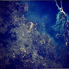
ブリスベン大都市圏の国際宇宙ステーションから撮影された衛星写真
ブリスベンはオーストラリア、クイーンズランド州の南東部に位置する。市街地はブリスベン川の半島部に位置し、東部のサバーブ︵郊外︶はモートン湾沿いにまで広がる。また、ブリスベン大都市圏はグレートディバイディング山脈の東部、モートン湾沿岸の氾濫原に広がる平野にある。この地域には北部のカブルチャーから南部のビーンレー、南西部のイプスウィッチなどが含まれる。
ブリスベンには丘が多く[4]、中央業務地区を含む都市域は標高約300mのクーサ山や、より低いエノゲラ・ヒルのような山を含むタイラー山地の裾野に位置している。
またブリスベン周辺にはマウント・グラベットやトゥーイーズ山付近などの、標高約170mのピートリー山やハイゲート・ヒル、ステファンズ山、ホワイト・ヒルなど、市内に散在している。
市街地には多くの小川があり、洪水の危険性を増大させている。ブリスベン市は植民地化以降の1893年、1974年、2011年、2022年の4度の大洪水を経験している。特に記録的な洪水となった1974年のブリスベン洪水はサイクロン・ワンダが原因の一つとなっている。1974年のオーストラリアの日︵1974年1月26日-27日︶の前の約3週間大雨が続き[5]、この結果、オックスレイ、ブリンバ、ロックレア、クーパルー、トゥーオング、ニューファームなどのブリスベンの多くのサバーブに洪水による被害を出した。またブリスベン・シティー植物園は水没し、この時にブリスベン川のシティー側にマングローブの新しい群落が形成された[6]。2011年のブリスベン洪水と2022年のブリスベン洪水では、水位は1974年に達しなかったが、郊外を中心に甚大な被害がもたらされた。

ブリスベン商業中心地区およびブリスベン・シティ植物園︵左︶

ハミルトン地区よりシティを望む
ブリスベン中央業務地区(CBD)はブリスベン川の半島部に位置する。中心業務地区は約2.2km2である。
中心街の道路名はハノーヴァー朝の王室の名前に由来する。ビクトリア女王に敬意を表し名付けられたクイーン・ストリートは、ブリスベンの伝統的な中心街となっている。またクイーン・ストリートには、歩行者専用道路となっているクイーン・ストリート・モールがあり、ショッピング街となっている。クイーン・ストリートに平行する道路名は女性王族の名前︵アデレード、アリス、アン、シャーロット、エリザベス、マーガレット、メアリー︶にちなみ、またこれらに垂直に並ぶ通りは男性王族の名前︵アルバート、エドワード、ジョージ、ウィリアム︶に由来している。
シティには1820年代に建設された歴史的な建築物が残っている。ウィッカム公園のオールド・ウィンドミルは1824年に受刑者により建てられ[7][8]、ブリスベンに残っている建築物では最も古い物である。オールド・ウィンドミルは穀物をひくために使われ、受刑者の刑罰として手動で製粉していた。また、1934年4月に南半球で最初にテレビの試験放送を行った場所でもある。この実験的なテレビ報道は世界第二次大戦まで続けられた[7]。
1828年に受刑者により建てられたウィリアム・ストリートのコミッサリー・ストアは、穀物倉庫として一部が使われており、移民者のホステルとしても使用され、また記録保管庫としても使われた。カンガルー・ポイント・クリフの近くのブリスベン・タフおよびアルビオン・パーク・レースコースの砂岩で建てられ、現在はブリスベン王立歴史協会の本部となっている。博物館があるほか、小規模の会合、式典などに貸し出されることがある[9][10][11]。
シティの人口密度は1平方キロメートルあたり379.4人であり、これはオーストラリアでは高い方でありシドニーの人口密度に匹敵する。しかしながら多くの西洋の都市と同じように郊外の庭付住宅の需要は根強く、ブリスベンの人口は周辺域へと広がりつつある。

ウィリアム・ジョリー橋よりシティの西側を望む
初期の法律により居住ブロックの最小規模が定められ、その結果、ブリスベンに建築されたテラスハウスは少数にとどまることとなった。アパートメントのような集合住宅はブリスベンでは比較的新しく、1970年以前はシティ近接のサバーブに少数が建設されただけである。近年ではシティおよびシティ近郊の人口密度はアパートメントの増加により高くなっており、シドニーやメルボルンとの差は縮まった[12]。中心業務地区の人口は2004年6月から2009年6月の5年間で約2倍となり[13]、都心回帰の傾向がみられる。
1950年以前の住居はクイーンズランダーという様式で建てられていた。トタンの切妻屋根と大きなベランダが外観の特徴で、高温多湿の気候に対応した高床式の木造住宅である。現在では珍しくなっているが、郊外で新築物件の供給が行われている。これらクイーンズランダー様式の家は杭︵'stilt'︵竹馬︶とも呼ばれる︶により高く持ち上げられる。この杭は元々は木材が使用されていたが、近年は鉄筋やコンクリートが使用されることが多い。サウス・イースト・クイーンズランド地域の材木の値段が比較的安いのは、近年まで多くの住居が、ブロックや石材よりもむしろ、木材で建築されることが多かったためである。
ブリスベン市庁舎は高さ91mの時計塔を備えており、長年に渡り市内で最も高い建築物だった。現在、ブリスベンには高さ100m以上の建築物は70棟以上あり増加している。最も高いのは2019年に完成したブリズベンスカイタワー(270m)である。

ブリスベンの一年間の平均気温と平均降水量のグラフ
ブリスベンはケッペンの気候区分の温暖湿潤気候Cfaに属し、夏は湿度が高く暑くなり、冬は乾燥し温暖な気候である[14]。11月から3月までは雷雨がよくあり、また時折、激しい雨、風が伴うことがある。
ブリスベンで記録された最高気温は1940年1月26日の43.2℃である。また、2007年7月19日にはブリスベン空港で記録上初めて氷点下になり、-0.1℃を記録した[15]。2009年8月24日には、冬としては最も気温の高い35.4℃を記録している。最も降水のあった日は1887年1月21日であり、465mmを記録し、この記録はオーストラリアの州都においても最大の記録である。
ブリスベンおよび周辺地域では、2001年から2008年までの間、この100年間で最も記録的な干ばつがあり、2007年8月10日にはダム貯水量が16.9%にまで下がった。居住者は法律により、レベル6という高い水の供給制限を受け、庭や屋外での水の使用が制限された。一人あたりの水の使用量は1日あたり140リットル以下に制限され、これは世界の他の欧米諸都市の中で最も低いものであった[16]。2008年のはじめにブリスベンの周辺ダムの貯水量は98%までに回復している[17]。水の供給制限は、一日、一人あたり200リットルへと変更されたが、需要量は160リットルを上回ることはまれである。
ブリスベンにおいては砂嵐はかなり珍しいが、2009年9月23日に起こった砂嵐においては、他のオーストラリア東部の都市と同様にブリスベンにおいても記録された[18][19]。
ブリスベンはまたサイクロンの影響を受ける地域でもあるが、ブリスベンにサイクロンが直接上陸することは稀である。2009年3月に熱帯性サイクロンのハーミッシュがブリスベン付近を通過し、ブリスベンの北部の約350kmに渡り傷跡を残したが[20]、このときの最も大きな被害はモートン湾で起きた、座礁した船によって引き起こされた燃料漏れ事故である[21]。
歴史[編集]
主要記事‥History of Brisbane
歴史上の著名なブリスベン出身者[編集]
●ピーター・ドハーティー、医学研究者及びノーベル賞受賞者 ●ビル・ハイドン、元オーストラリア総督 ●チャールズ・キングスフォード・スミス、飛行士のパイオニア、1928年に彼の飛行機﹁サザンクロス﹂で初めて太平洋を横断した。 ●エンマ・ミラー、労働運動家、参政権運動家のパイオニア ●ウィリアム・F・ウエップ, Hon Sir William Flood Webb KBE‥ オーストラリア高等裁判所裁判官、極東軍事法廷裁判長地理[編集]

都市構造[編集]


気候[編集]

| ブリスベンの気候 | |||||||||||||
|---|---|---|---|---|---|---|---|---|---|---|---|---|---|
| 月 | 1月 | 2月 | 3月 | 4月 | 5月 | 6月 | 7月 | 8月 | 9月 | 10月 | 11月 | 12月 | 年 |
| 最高気温記録 °C (°F) | 43.2 (109.8) |
41.7 (107.1) |
37.9 (100.2) |
33.7 (92.7) |
30.7 (87.3) |
29.0 (84.2) |
28.2 (82.8) |
35.4 (95.7) |
35.1 (95.2) |
38.7 (101.7) |
34.0 (93.2) |
40.0 (104) |
43.2 (109.8) |
| 平均最高気温 °C (°F) | 30.2 (86.4) |
30.0 (86) |
28.9 (84) |
27.2 (81) |
24.5 (76.1) |
22.0 (71.6) |
21.9 (71.4) |
23.3 (73.9) |
25.8 (78.4) |
27.2 (81) |
27.8 (82) |
29.4 (84.9) |
26.5 (79.7) |
| 平均最低気温 °C (°F) | 21.4 (70.5) |
21.3 (70.3) |
19.8 (67.6) |
17.3 (63.1) |
13.6 (56.5) |
11.6 (52.9) |
9.8 (49.6) |
10.5 (50.9) |
13.7 (56.7) |
16.3 (61.3) |
18.5 (65.3) |
20.4 (68.7) |
16.2 (61.2) |
| 最低気温記録 °C (°F) | 17.0 (62.6) |
16.5 (61.7) |
12.2 (54) |
10.0 (50) |
5.0 (41) |
5.0 (41) |
3.0 (37.4) |
4.1 (39.4) |
7.0 (44.6) |
10.6 (51.1) |
10.8 (51.4) |
14.0 (57.2) |
3.0 (37.4) |
| 降水量 mm (inch) | 95.9 (3.776) |
127.7 (5.028) |
89.3 (3.516) |
56.3 (2.217) |
63.6 (2.504) |
59.6 (2.346) |
23.0 (0.906) |
35.6 (1.402) |
26.3 (1.035) |
61.3 (2.413) |
116.2 (4.575) |
128.4 (5.055) |
883.3 (34.776) |
| 平均降水日数 | 11.7 | 11.8 | 12.5 | 11.8 | 9.5 | 9.1 | 6.0 | 5.6 | 7.4 | 9.1 | 12.5 | 12.9 | 119.9 |
| 出典:オーストラリア気象局[22] | |||||||||||||
行政[編集]
- ブリスベン市の人口:1,052,458人 (2009年) [23]
- ブリスベン大都市圏(6つの隣接自治体 (LGA)を含む)人口:2,004,262人(2009年)[23] 2,560,720人(2020年)[24]

他のオーストラリアの州都とは違い、ブリスベン大都市圏の大部分はブリスベン市議会のもとで統治されている。1925年にブリスベン市議会が創設されて以来、ブリスベンの都市域は市の境界を超え広がり続けた[25]。1925年以前はブリスベン地方自治議会︵Brisbane City Council︶により、現在のブリスベンのインナーサバーブが統治されていた。
ブリスベン市は人口および予算の面でオーストラリアで最も大きな自治体である[23]。1925年に20の小さな自治体が合併し、現在の市の面積は1376平方キロメートルとなった。市の2010年度年間予算は約3億豪ドルであり、資産は約216億豪ドルである[26]。
ブリスベン大都市圏は南部のローガン市、北のモートンベイ市、南西のイプスウィッチ市、東のレッドランド市、シーニック・リム市などを含む。
2020年10月現在、ブリスベン市長はエイドリアン・シュリナー。

州都として州政の中心都市であるブリスベンは、クイーンズランド州経 済の中心地でもある。
ブリスベンの経済は主に第二次、第三次産業の発展が顕著に見られる。
第二次産業では精油、船内荷役、製紙、金属加工術、クイーンズランド鉄道の鉄道工場などがあり、これらはブリスベン川の下流域や新しく建設された都市周辺部の工業地帯に建設される傾向がある。第三次産業では、一般的に市中心部のCBD(Central Business District=中心商業地区)に建設された高層商業ビルや、近年作られた近接郊外の商業団地でIT、金融サービス、高等教育、公共機関などが発展している。観光業はブリスベンへの観光だけではなく、クイーンズランド州の玄関口としても機能しブリスベンの重要な産業である。
伝統的にブリスベンは、シドニーやメルボルンに本拠地を構える大企業の支社・支店が集中する支店経済都市のような性質を持っている。多様化を図るために1990年代後半から2000年代前半に州政府は、“スマートステイト”キャンペーンを展開しクイーンズランド︵特にブリスベン︶にあるの幾つかの生命工学︵バイオテクノロジー︶とブリスベンの大学のリサーチ施設に投資した。
経済[編集]
人口構成[編集]
| 主な出身国別の人口構成[27] | |
| 出身国 | 人口 (2006) |
|---|---|
| イギリス | 95,315 |
| ニュージーランド | 73,128 |
| 南アフリカ | 12,824 |
| ベトナム | 11,857 |
| 中華人民共和国 | 11,418 |
| フィリピン | 9,871 |
| ドイツ | 8,645 |
| インド | 7,544 |
| オランダ | 7,014 |
| フィジー | 6,791 |
| パプアニューギニア | 6,706 |
| イタリア | 6,704 |
| マレーシア | 6,686 |
| アメリカ合衆国 | 6,057 |
| 香港 | 6,036 |
| 大韓民国 | 4,841 |
| ブリスベンの人口 | ||
|---|---|---|
| 1859 | 6,000 | |
| 1942 | 750,000 | |
| 2006 | 1,763,131[28] | |
| 2020 | 2,560,720[24] | |
| 2026 | 2,908,000[29] | 計画 |
| 2056 | 4,955,100[29] | 計画 |
イプスウィッチ、モートンベイ、ローガン、レッドランドなどを含むブリスベン大都市圏は人口統計学的に一つのコナベーションとされる。2006年の国勢調査ではブリスベン大都市圏には1,763,131人が居住していることが記録された[28]。ブリスベン大都市圏はオーストラリアで3番目に大きい都市圏である[28]。
オーストラリアの首都圏においては最も高い人口増加率を示し、2001年から2006年の人口増加率は年間平均2.2%であった[30]。年齢の中央値は35歳である[31]。
2006年の調査ではブリスベンの人口のうちオーストラリア先住民は1.7%、21.7%は海外生まれであり、国外生まれでは、ニュージーランド、南アフリカ、イギリスで生まれた者が多かった[31]。また、約16.1%の家庭が英語以外の言語を話し、うち北京語が1.1%、ベトナム語が0.9%、広東語が0.9%、イタリア語が0.6%、サモア語が0.5%である[31]。

ブリスベン中心部の地図
シティーの旅行者に人気があるのは、2000年から2001年にかけ改修したローマストリート公園、(植民地時代からある植物園である︶ブリスベンシティー植物園、1988年世界万博の開催地であったサウス・ブリスベンにあるサウスバンク公園などである。旅行者も市民も同様に、美しいブーゲンビリアの並ぶリバーサイドウオークウェイを季節を問わず歩き、音楽やアートフェスティバルに集う。
主要なショッピングエリアはCBD︵シティー︶にあるクイーン・ストリート・モールや、フォーティテュード・ヴァレーにある中華街などがあげられる。ブリスベン川沿いにはカンガルーポイントではロッククライミングやカヤッキングなどが楽しめる。また、マウント・クーサにはシティーを見渡せるサミット展望台、マウント・クーサ植物園、セント・トーマス・ブリスベン・プラネタリウムがある。
世界で最も大きく古いコアラの保護区であるローンパイン・コアラ・サンクチュアリもブリスベン市内の観光地として人気がある。
キャッスルメイン・パーキンスXXXXビール のミルトンの醸造所は月曜日から金曜日、ツアーがある。

草間彌生パブリックアート作品﹁Eyes Are Singing Out﹂︵2012︶ブリスベンジョージ・ストリート

ストーリーブリッジ
ブリスベンには多くの歴史的、近代的建造物が建築されている。
ストーリーブリッジ
フォーティテュード・ヴァリーとカンガルー・ポイントを結ぶカンチレバーブリッジ。シドニーのハーバーブリッジのように、大恐慌のときに公共事業で建設された。夜はライトアップされ、毎年行われるブリスベンリバー・フェスティバルの会場の一つでもある。アーチ上部を上るブリッジ・クライムの観光アトラクションが用意されている。
ブリスベン・シティーホール
時計塔のあるシティーホールは1971年にシドニーのシドニー・オペラハウスができるまで、オーストラリアで一番高い費用がかかった建物だった。1930年完成[35]。今でも市役所の本部が置かれ、ブリスベンの歴史博物館や美術館などがあり、昼間は時計台を一般に開放している。時計台に上るためのエレベーターは手動であり、オペレーターが操作をする。時計台には鐘が設置されており、15分おきに鐘が鳴らされる。2010年から2012年までの間は改修工事のために閉館されており、市役所の本部は一時的に移動されている。
クイーンズランド議事堂
ジョージストリート、ブリスベンのクイーンズランド州立議会の地区にある。植民地時代の1880年代に建てられた。
旧行政府
1820年代後半から1830年代前半にかけて建設された。最初のクイーンズランド総督であるサー・ジョージ・ファーガソンの住居で、今はクイーンズランド工科大学の敷地内にある。
ザ・マンションズ
植民地時代の1889年に建てられた。クイーンズランド最初の女性医師の家で、クイーンズランド議事堂と同じ年代の古さであり、近くに建っている。
ウィンドミル
1820年代にコムギを挽くために受刑者によって建てられた
総郵便局ビル
1800年代建設
トレジャリー・カジノ︵旧財務省ビル︶
ジョージストリート行政地区のトップの砂岩の建物
ステート・ロー・ビル︵州法務省ビル︶
そのポストモダンなデザインでゴッサムタワー、あるいは特徴的なトップのためにバットマンビルディングと地域の人々に呼ばれる。コンラッド&ガーゲットの地元の建築家のデザインによって改修された。
法廷総合地区
ステートロービルの近くで、クイーンズランド最高裁判所とクイーンズランド地方裁判所がある。
ニューステッドハウス
ブリスベン川のブレックファスト・クリーク沿いに、クイーンズランド最初の総督のために建てられた。その後は、優雅な私邸として軍のキャプテン、奴隷貿易者、オペラ歌手、新聞富豪が住んだ。現在は公開されている。
ブリスベン・エキシビジョン地区
RNA (Royal National Agricultural and Industrial Association of Queensland)の運営で、毎年60万人以上が訪れる“エッカ”が催される。
AMPプレイス
ブリスベンの最初の‘本当の’高層ビル、130mで1978年に建てられた。
リパリアン・プラザ
屋上まで 200m のブリスベンの現在一番高い建物で、250m の尖塔を内包する。53階建ての複合用途のビルは、ハリー・セイドラーのデザインで2005年に完成した。
セントラルプラザI&II
1988年に建設され日本人建築家黒川紀章による設計。
リバーサイド・センター
1986年にハリー・セイドラーによるデザイン。
ザ・スカイニードル
1988年に世界万博のために建設され、88mの高さでスペシャルイベントの間には光が空に向かって放射され、60km以上遠くからでも視認できる。
ブリスベン市の人口構成[編集]
2006年の国勢調査ではブリスベン市の人口は956,130人であった。このうちオーストラリア市民権所持者は806,379人(84.3%、オーストラリア平均86.1%)、海外生まれは229,173人(24%、同23.8%)、オーストラリア先住民は12,938人(1.4%、同2.3%)であった[32]。また海外生まれのうち、英語圏出身者は97,168人(10.2%)、英語圏以外の出身者は132,005人(13.8%)であった。 1987年までブリスベン南部の地区のワコール︵Wacol︶にワコール移民局があったため、ブリスベン南部に海外生まれ人口が多い地域が集中した[33]。2001年から2006年の間にブリスベン市の人口は89,801人増加し、うち海外生まれの人口は31,431人であり、かつ英語圏以外の出身者が21,984人を占める[32]。 ブリスベン南部の地区であるサニーバンクは東アジア出身者の多いサバーブの一つであり、41.5%が海外生まれである[32][34]。英語圏出身者別(7.6%)ではニュージーランド(3.5%)、イギリス(3.4%)、英語圏以外(33.9%)では中国本土(8.6%)、台湾(7.3%)、香港(2.3%)であった[32]。ブリスベンはオーストラリア国内で最も台湾系移民が多い地域である。中華街のあるフォーティテュード・ヴァリーにおける中国本土出身者の割合は1.6%であり、ブリスベンにおける中国本土出身者(1.0%)に比べるとわずかに多いが、サニーバンクに比べると少ない[32]。サニーバンクには中国系レストランも多くあり[34]、そのためサニーバンクとその周辺は‘本当の中華街’、‘台湾街’などと言われることがある。また、ベトナム人は南部のイナラ︵14.3%/海外出身者33.8%︶やダラ︵15.2%/同40.8%︶周辺に多い[32]。 インナーサバーブ南部は、ギリシア人やイタリア人を中心に南ヨーロッパ出身者が多い。シティー周辺にはセルビア人、ボスニア人、クロアチア人、インド人、パキスタン人、南アフリカ人、フィジー人などが多い。文化[編集]
観光[編集]


歴史的建造物[編集]

博物館・美術館[編集]
●クイーンズランド海洋博物館︵英語︶ ●クイーンズランド博物館︵英語︶ - 博物館は以前催し物ホールにあった。現在はサウスバンクのクイーンズランド文化センターに移動し、催し物ホールはクイーンズランドユースオーケストラのホームになっている。 ●クイーンズランド美術館︵英語︶メディア[編集]
7つのテレビジョン放送局サービス‥スポーツ[編集]
ブリスベンに本拠を置くスポーツチーム:
|
|
教育[編集]
単科及び総合大学[編集]

多くの高等教育施設がブリスベン、または隣接地域内にキャンパスを置いている:
- クイーンズランド大学 (UQ)
- グリフィス大学 (GRIFFITH)
- クイーンズランド工科大学 (QUT)
- ボンド大学 (Bond)
- サザンクイーンズランド大学 (USQ)
- セントラルクイーンズランド大学 (CQU)
- サンシャインコースト大学 (USC)
- オーストラリアカトリック大学 (ACU)
- ニューサウスウェールズ大学 (UNSW)
- Brisbane College of Theology
参照:オーストラリアの大学一覧
TAFE(テイフ)[編集]
|
|
|
交通[編集]
詳細は「ブリスベンの交通」を参照

ブリスベンは市内の交通網がよく発展しているとともに、州内各地、オーストラリア各州、海外などへの交通の拠点ともなっている。しかし、公共交通機関は住民の移動手段としてはまだ不十分であり、個人所有の車による移動が大部分を占める[36]。
ブリスベン市内にはバス、鉄道およびフェリーの公共交通機関がある。バスは公営および民営の会社により運営されており、また、電車やフェリーはブリスベン市により運営されている。ブリスベン中央商業地区はセントラル駅、ローマ・ストリート駅、クイーン・ストリート・バス駅などがハブ駅となり多くの公共交通機関の中心地となっている。ブリスベンのシティーキャットは上流のクイーンズランド大学から下流のアポロ・ロードまでを結ぶフェリーサービスであり、住人はもとより観光客にもよく使われる交通機関である。また、より近距離のフェリーサービスであるシティーフェリーも運航されている。
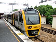
ナンボー駅に停車する電車
シティートレインは特にシティーの西、北、東方面をカバーする鉄道路線であり、10路線が運営されている。エアトレインはシティとブリスベン空港をつなぐ民営の路線であり、官民共同で運営されている。2000年以降、バスの運行を円滑にするために、サウスイーストバスウェイやノーザンバスウェイのようなバス専用道路を発展させてきた。このバス専用道路のため近年ではバスが渋滞に巻き込まれることは少なくなった。トランスリンクが発行するチケットやゴーカードは異なる公共交通機関の間で相互利用が可能である。

ローマ・ストリート駅にあったトランジット・センター。州外へ向かう 長距離列車や長距離バスの発着所である。
クイーンズランド鉄道︵QR︶の一機関であるトラベルトレインは、州内各方面への長距離列車を運行している。レールコープの機関であるカントリーリンクは、シドニーへの長距離列車を運行している。これらはローマストリート駅に発着する。
ブリスベン川は、道路交通網の妨げとなっている。その結果、ブリスベン川を横切る10箇所の橋が作られた。これはブリスベン市内の公共交通網の必要性を強めた。また、3カ所の鉄道橋および2カ所の歩行者専用橋がある。また、グリーン・ブリッジという別名でも知られるエレナー・ショネル・ブリッジは、クイーンズランド大学とダットン公園を結ぶバス、歩行者および自転車専用の橋である。トランスアペックス計画により、複数のトンネルや橋の建設が計画されている。
ブリスベン市議会によりシティーサイクルと呼ばれる自転車の貸し出しシステムが整備されており、2011年までに市内に150カ所のシティーサイクル駅が整備され、最大2000台の自転車が市民の足として提供される予定である[37]。
ブリスベン川沿いには歩行者およびサイクリスト向けに、リバーウォークとよばれる歩道が整備されている[38]。
ブリスベンにはいくつかのフリーウェイが整備されている。パシフィック・モータウェイは南部のゴールドコーストとシティーを結ぶ路線である。また、イプスウィッチ・モーターウェイはブリスベン西部のイプスウィッチを結ぶ路線であり、ウェスタン・フリーウェイおよびセンテナリ・フリーウェイがブリスベン市内からイプスウィッチ・モーターウェイへと接続している。一方、北部へはブルース・ハイウェイが主要道路となっている。ブルース・ハイウェイはケアンズまで約1700kmあるフリーウェイであり、大部分がクイーンズランド州の沿岸地帯を通っている。
ゲートウェイ・モーターウェイはブリスベン市街地を避け、ゴールドコーストからサー・レオ・ヒールシャー・ブリッジを経由してサンシャイン・コーストへと抜けるルートであり、有料道路である。ブリスベン港モータウェイはゲートウェイ・モーターウェイとブリスベン港を結ぶ道路であり、またインナーシティ・バイパスとリバーサイド高速道路は、市内の混雑を防ぐための環状線として機能している[39]。
ブリスベンの急激な人口増加はサウス・イースト・クイーンズランドの交通システムの懸念材料となっている。州政府およびブリスベン市議会はサウス・イースト・クイーンズランド・インフラストラクチャー計画のような交通網整備プロジェクトに資金を供給しながら、インフラストラクチャー計画を発展させてきた。特にトンネルやバイパス、公共交通機関の改善などをはじめ、既存の道路網の改善および拡張に力を注いできた。

ブリスベン空港の国際線ターミナル
ブリスベン空港はブリスベンの主要な空港であり、オーストラリア国内ではシドニー空港、メルボルン空港に次ぎ3番目に利用者の多い空港である。街の中心地の北東部に位置しており、市内から空港へはエアトレインと呼ばれる鉄道で接続されている。またブリスベン南部のサバーブであるアーチャーフィールドに、アーチャーフィールド空港がありゼネラル・アビエーション空港として機能している。他に小規模の空港がカブルチャーとレッドクリフに存在する。


ブリスベンの関連項目[編集]
●ブリスベンの人々 ●ブリスベンの地名︵サバーブ︶ ●ブリスベンの鉄道駅 ●ブリスベンの橋 : ブリスベンの橋 - 歩道橋、鉄道橋を含む ●ブリスベンの交通 : バス、鉄道、シティ・キャット︵フェリーサービス︶ ●在ブリスベン日本国総領事館ブリスベン近郊[編集]
●ゴールドコースト‥ブリスベンの南東約70キロメートル(km)にある。ここはおおよそ約40 km のビーチ、複数のテーマパーク、運河と山地を擁する主要な観光地である。 ●サンシャイン・コースト‥後背地の亜熱帯地域の砂浜に面したコミュニティー。 ●トゥーンバ‥内陸部に位置する庭園都市であり大分水嶺山脈の海抜700 メートル にある。 ●イプスイッチ ‥ブリスベンの南西おおよそ40 km に位置する衛星都市であり、町の北にあるクイーンズランド鉄道の工場でよく知られる。 ●モートン島‥ブリスベン東約40kmのモートン湾沖にある島。島の約98%が国立公園姉妹都市[編集]
|
|
|
ブリスベンの姉妹都市の公式な一覧:List of Sister Cities(英語)
出典[編集]
(一)^ Macquarie ABC Dictionary. The Macquarie Library Pty Ltd. (2003). p. 121. ISBN 1 876429 37 2
(二)^ “IOC set to vote on Brisbane as 2032 Host City”. The Japan Times. 2021年6月12日閲覧。
(三)^ ﹁2032年夏季五輪・パラは豪ブリスベンで決定 IOC総会﹂﹃BBCニュース﹄。2021年7月22日閲覧。
(四)^ Gregory, Helen (2007). Brisbane Then and Now. Wingfield, South Australia: Salamander Books. pp. 60. ISBN 9781741730111
(五)^ Gunn, Angus M. (1978). Habitat: Human Settlements in an Urban Age. Pergamon Press. pp. 178. ISBN 0080214878
(六)^ “Timeline for Brisbane River” (PDF). Coastal CRC. 2008年2月16日時点のオリジナルよりアーカイブ。2008年1月4日閲覧。
(七)^ abCampbell Newman, "bmag", 3 November 2009
(八)^ “TimeWalks Brisbane — Windmill”. Queensland Government (2008年3月24日). 2007年12月19日時点のオリジナルよりアーカイブ。2008年4月10日閲覧。
(九)^ Statham-Drew, Pamela (1990). The Origin of Australia's Capital Cities. Cambridge University Press. pp. 257. ISBN 978-0521408325
(十)^ Pike, Jeffrey (2002). Australia. Insight. ISBN 978-9812347992
(11)^ “The Commissariat Stores”. 2008年5月23日時点のオリジナルよりアーカイブ。2008年2月24日閲覧。
(12)^ “Indicator: HS-06 Population density patterns in major cities”. Department of the Environment, Water, Heritage and the Arts. Government of Australia. 2008年1月12日閲覧。
(13)^ [1] Australian Bureau of Statistics - 2010年10月8日閲覧
(14)^ Linacre, Edward; Geerts, Bart (1997). Climates and Weather Explained. London: Routledge. p. 379. ISBN 0-415-12519-7
(15)^ Daniel Sankey and Tony Moore (2007年7月19日). “Coldest day on record for Brisbane”. The Brisbane Times. 2008年1月5日閲覧。
(16)^ “Brisbane residents best water savers in world: Newman”. ABC News. 2008年3月19日閲覧。
(17)^ “SEQWater latest dam levels”. 2012年10月14日時点のオリジナルよりアーカイブ。2010年10月11日閲覧。
(18)^ Cubby, Ben (2009年9月23日). “Global warning: Sydney dust storm just the beginning”. Brisbane Times (Brisbane) 2009年9月25日閲覧。
(19)^ Brisbane on alert as dust storms sweep east
(20)^ “Severe Tropical Cyclone Hamish”. Australian Bureau of Meteorology (2010年). 2010年8月11日閲覧。
(21)^ Staff Writer (2009年3月11日). “Ship spills chemicals in waters off Australia”. Cable News Network. 2009年3月11日閲覧。
(22)^
Bureau of Meteorology. “Climate statistics for Australian locations”. 2010年10月11日閲覧。
(23)^ abcAustralian Bureau of Statistics. “Regional Population Growth, Australia, 2008-09”. 2010年10月19日閲覧。
(24)^ ab“Regional population, 2019-20 financial year | Australian Bureau of Statistics” (英語). www.abs.gov.au (2021年4月13日). 2021年7月22日閲覧。
(25)^ “Brisbane City Council”. NetCat. 2007年8月29日時点のオリジナルよりアーカイブ。2007年12月28日閲覧。
(26)^ “Council budget 2010-2011”. Brisbane City Council. 2010年10月19日閲覧。
(27)^ Australian Bureau of Statistics (2007年10月25日). “Community Profile Series : Brisbane (Major Statistical Region)”. 2006 Census of Population and Housing. 2009年12月27日閲覧。
refer "Basic Community Profile - Brisbane" sheet B10
(28)^ abcオーストラリア統計局 (2007年10月25日). “2006 Census QuickStats: Brisbane (Statistical Division)”. 2006 Census QuickStats. 2008年3月21日閲覧。
(29)^ ab“3222.0 - Population Projections, Australia, 2006 to 2101”. 3222.0 - Population Projections, Australia, 2006 to 2101. オーストラリア統計局 (04-23-2009). 2010年10月23日閲覧。
(30)^ “3218.0 - Regional Population Growth, Australia, 1996 to 2006”. オーストラリア統計局. 2008年3月3日閲覧。
(31)^ abcAustralian Bureau of Statistics (2007年10月25日). “Community Profile Series : Brisbane (Statistical Division)”. 2006 Census of Population and Housing. 2008年1月21日閲覧。 Map
(32)^ abcdefオーストラリア統計局. “Brisbane City Community Profile”. 2010年10月23日閲覧。
(33)^ オーストラリア統計局. “Brisbane Social Atlas”. 2010年10月23日閲覧。
(34)^ abOurBrisbane. “Sunnybank”. 2010年10月23日閲覧。
(35)^ ﹃ゴールドコースト・ブリスベン ケアンズ・グレートバリアリーフ ことりっぷ 海外版﹄昭文社、2017年、46頁。ISBN 978-4-398-15522-1。
(36)^ “Year Book Australia, 2005”. ABS. 2008年2月19日閲覧。
(37)^ Brisbane City Council. “CityCycle”. 2010年10月23日閲覧。
(38)^ “About RiverWalk”. Brisbane City Council. 2008年5月22日時点のオリジナルよりアーカイブ。2008年1月5日閲覧。
(39)^ “The upgrade”. Gateway Upgrade Project. 2011年7月6日時点のオリジナルよりアーカイブ。2008年1月5日閲覧。
外部リンク[編集]
公式
日本政府
- 在ブリスベン総領事館 (日本語)
観光
- オーストラリア政府観光局 - ブリスベン (日本語)
- ブリスベンの気候と服装|オーストラリア政府観光局 教育旅行公式サイト(日本語)
- ブリスベンの交通機関と地図|オーストラリア政府観光局 教育旅行公式サイト(日本語)
| |||||
| ||||||
| 全般 |
|
|---|---|
| 国立図書館 |
|
| 地理 |
|
| その他 |
|