
サウスダコタ州
- サウスダコタ州
- State of South Dakota
-

(州旗) (州章) - 州の愛称: ラシュモア山の州
The Mount Rushmore State 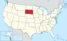
-
州都 ピア 最大の都市 スーフォールズ 州知事 クリスティ・ノーム 公用語 英語 [1] スー語 [2] 面積
- 総計
- 陸地
- 水域全米第17位
199,905 km²
196,735 km²
3,173 km² (1.6%)人口(2020年)
- 総計
- 人口密度全米第46位
886,667人
4.5人/km²合衆国加入
- 順番
- 加入年月日
40番目
1889年11月2日時間帯 UTC -6, -7
DST -5, -6緯度 北緯42°29' - 45°56' 経度 西経96°26' - 104°3' 東西の幅 340 km 南北の長さ 610 km 標高
-最高標高
-平均標高
-最低標高
2,208 m
670 m
295 m略称 (ISO 3166-2:US) US-SDウェブサイト サウスダコタ州政府 上院議員 ジョン・スーン
マイク・ラウンズ


サウスダコタ州︵サウスダコタしゅう、英: State of South Dakota [ˌsaʊθ dəˈkoʊtə] ( 音声ファイル)︶は、アメリカ合衆国の中西部にある州。グレートプレーンズ︵大平原︶にあり、南西部はハイプレーンズと呼ばれる標高の高い平原地帯でもある。州の北はノースダコタ州に、東側はミネソタ州とアイオワ州に、西側はモンタナ州とワイオミング州に、南側はネブラスカ州に接している。州の中央にはミズーリ川が南北に流れているので、その東側と西側には地理的にも社会的にもはっきりとした特徴の違いがあり、州民は﹁イーストリバー﹂﹁ウェストリバー﹂と呼んでいる[3]。
州都は州中央部のピア市であり、人口最大の都市は州東端、ミネソタ州、アイオワ州との州境に近いスーフォールズ市。﹁ダコタ﹂という名前はインディアン部族のダコタ族︵スー族︶の言葉﹁ダコタ︵仲間︶﹂に由来する。面積ではアメリカ合衆国50州の中で第17位だが人口では第46位、人口密度も第46位と過疎となっている。19世紀後半にできたダコタ準州の南側半分であり、1889年11月2日に40番目の州に昇格した。
州内東側には州民の大半が住んでおり、その肥沃な土壌で様々な農作物が栽培されている。西側は牧畜業が盛んであり、その経済は観光業と防衛費に依存している。州南西部にはブラックヒルズと呼ばれる低木の松に覆われた山脈があり、スー族の聖地である。ここには4人の大統領の顔のモニュメントで有名な観光地ラシュモア山国立記念公園がある。他にもバッドランズ国立公園、クレイジー・ホース記念碑、ウインドケーブ国立公園、ジュエルケーブ国定記念物、カスター州立公園、また歴史ある町のデッドウッドなどが、訪れる人の多い観光地である。ウォール・ドラッグストアなど、民間主導で運営されている観光地・名所も少なくない。はっきりとした四季のある大陸性気候であり、雨量は東部で中程度、西部でやや少ない亜乾燥気候である。生態系は北アメリカ草原に典型的な様相を示している。
自然が豊富で多くの観光客が訪れる州という華やかな面がある一方、ゴールドラッシュ期にはインディアンと白人との激しい抗争が繰り返された州でもある。全米で最も経済的に貧しい地域がある州であり、現在でも、インディアン居留地の貧困は、サウスダコタ州が抱える大きな問題として残っている。
音声ファイル)︶は、アメリカ合衆国の中西部にある州。グレートプレーンズ︵大平原︶にあり、南西部はハイプレーンズと呼ばれる標高の高い平原地帯でもある。州の北はノースダコタ州に、東側はミネソタ州とアイオワ州に、西側はモンタナ州とワイオミング州に、南側はネブラスカ州に接している。州の中央にはミズーリ川が南北に流れているので、その東側と西側には地理的にも社会的にもはっきりとした特徴の違いがあり、州民は﹁イーストリバー﹂﹁ウェストリバー﹂と呼んでいる[3]。
州都は州中央部のピア市であり、人口最大の都市は州東端、ミネソタ州、アイオワ州との州境に近いスーフォールズ市。﹁ダコタ﹂という名前はインディアン部族のダコタ族︵スー族︶の言葉﹁ダコタ︵仲間︶﹂に由来する。面積ではアメリカ合衆国50州の中で第17位だが人口では第46位、人口密度も第46位と過疎となっている。19世紀後半にできたダコタ準州の南側半分であり、1889年11月2日に40番目の州に昇格した。
州内東側には州民の大半が住んでおり、その肥沃な土壌で様々な農作物が栽培されている。西側は牧畜業が盛んであり、その経済は観光業と防衛費に依存している。州南西部にはブラックヒルズと呼ばれる低木の松に覆われた山脈があり、スー族の聖地である。ここには4人の大統領の顔のモニュメントで有名な観光地ラシュモア山国立記念公園がある。他にもバッドランズ国立公園、クレイジー・ホース記念碑、ウインドケーブ国立公園、ジュエルケーブ国定記念物、カスター州立公園、また歴史ある町のデッドウッドなどが、訪れる人の多い観光地である。ウォール・ドラッグストアなど、民間主導で運営されている観光地・名所も少なくない。はっきりとした四季のある大陸性気候であり、雨量は東部で中程度、西部でやや少ない亜乾燥気候である。生態系は北アメリカ草原に典型的な様相を示している。
自然が豊富で多くの観光客が訪れる州という華やかな面がある一方、ゴールドラッシュ期にはインディアンと白人との激しい抗争が繰り返された州でもある。全米で最も経済的に貧しい地域がある州であり、現在でも、インディアン居留地の貧困は、サウスダコタ州が抱える大きな問題として残っている。
歴史[編集]
詳細は「サウスダコタ州の歴史」を参照
サウスダコタ州となった地域には少なくとも数千年前から人類が住んでいた。最初の住人は狩猟採集社会型のパレオ・インディアンであり、紀元前5000年ごろに姿を消した[5]。西暦500年から800年ごろ、マウンドビルダーと呼ばれる半遊牧民が中部と東部に住んでいた。14世紀、ミズーリ川近くで数百人の男女子供が殺されるという、いわゆるクロウクリーク虐殺が起こった[6]。1500年までにアリカラ族︵あるいはリー族︶がミズーリ川流域の多くに入っていた[7]。この地域へのヨーロッパ人による接触は、1743年にフランス人のラヴェランドリー兄弟が探検したのが始まりだった。ラヴェランドリー探検隊は現在のピア市近くに銘板を埋めており、それにはこの地域がフランス領ルイジアナの一部であることが書かれていた[8]。19世紀初期までにスー族がアリカラ族をほとんど排除し、地域を支配するようになっていた[9]。
1803年、アメリカ合衆国はフランスのナポレオン・ボナパルトからルイジアナを買収した。その範囲には今日のサウスダコタ州の大半が含まれていた。時の大統領トーマス・ジェファーソンは﹁ルイス・クラーク探検隊﹂と呼ばれる部隊を編成させ、新しく獲得した地域を探検させた[10]。1817年、アメリカ人の毛皮交易基地が現在のフォートピア市に設立され、この地域へのアメリカ人の入植が続くようになった[11]。1855年、アメリカ陸軍がピア砦を購入したが、翌年にはそこを放棄して、より便利な南のランドール砦に移った[11]。この時期にアメリカ人やヨーロッパ人による開拓が急速に進行し、1858年にはヤンクトン・スー族が条約に調印して、現在の州東部の大半をアメリカ合衆国に割譲した[12]。

デッドウッドの町、ブラックヒルズにある他の町と共に金の発見に続い て設立された
1856年、土地投機家達が現在のサウスダコタ州における最大都市であるスーフォールズを設立し[13]、1859年にはヤンクトン市を設立した[14]。1861年、アメリカ合衆国政府がダコタ準州を設立した。これには現在の南北ダコタ州とモンタナ州およびワイオミング州の一部も含まれていた[15]。地域の開拓はアメリカ合衆国東部からの人々と、ヨーロッパ西部と北部から移住してきた人々によって行われ[16]、特に1873年に東部からの鉄道がヤンクトンまで延びた後は急速に増加した[17]。1874年、ジョージ・アームストロング・カスターが軍隊を率いた遠征中に、ブラックヒルズで金が発見された[18][19]。坑夫や鉱山師がラコタ族に約束された土地に違法に侵入するようになった。
1868年の第二次ララミー砦条約によって、サウスダコタ州西半分がグレートスー居留地としてスー族に認められていたという事実があったにも拘わらず、カスターの遠征が挙行された。スー族はブラックヒルズ内の鉱業権や土地を渡すことを拒み、アメリカ合衆国政府が坑夫や開拓者が地域に入るのを止められなかったので、戦争が起きた。最終的にはアメリカ陸軍がスー族を破り、グレートスー居留地は5つの居留地に分割され、その地域のラコタ族を収容することになった[11]。1980年、アメリカ合衆国最高裁判所と連邦議会はブラックヒルズの違法な占拠についてラコタ族に賠償金を払うよう命じた。ラコタ族は賠償金の受け取りを拒み、土地の返還を求めたので、この訴訟は未解決である[20]。ダコタ準州内の人口が増えたので、1889年11月2日、ベンジャミン・ハリソン大統領は地域をノースダコタとサウスダコタに分け、州として昇格させる声明書に署名した[21][22]。ハリソン大統領は国務長官のジェイムズ・G・ブレインに、署名すべき2つの書類の順番を入れ替えて、どちらに最初に署名したか分からないように指示し、またその順序も記録しないようにしたので、誰もどちらが先に合衆国に加盟したか分かっていない[23][24]。しかし、ノースダコタ州がアルファベット順ではサウスダコタ州の前に来るので、ノースダコタ州昇格の声明書が法令集では先に出版された。この日以来、アルファベット順に並べるのが慣例となり、サウスダコタ州は40番目の加盟州となっている。
1890年12月29日、パインリッジ・インディアン居留地でウンデッド・ニーの虐殺が起こった。これは通常アメリカ合衆国とラコタ・スー族の最後の武装闘争だとされているが、少なくとも146人のスー族が死に、その多くは女性や子供だった[25]。アメリカ陸軍兵は31人が戦死した[25]。

1936年のダストボウルに襲われたサウスダコタ州の農場
1930年代、経済と気象の条件が組み合わされてサウスダコタ州の経済を襲った。サウスダコタ州やその他平原の州では、雨が降らず、異常な高温が続いたことと、不適切な耕作法とがいわゆるダストボウルを生み出すことになった。肥沃な表土は大量の砂嵐に吹き飛ばされ、農作物は壊滅的な損害を受けた。このダストボウルに加えて、地元の銀行による差し押さえや、世界恐慌の影響が及んだために、多くの州民は土地を離れることを余儀なくされた。1930年から1940年の間に州人口は7%以上減少した[26]。
1941年にアメリカ合衆国が第二次世界大戦に参入し、州内の農産物や工業生産品が戦争需要に対応して増加したので、経済の安定が取り戻された[27]。1944年、アメリカ合衆国議会で1944年洪水制御法の一部としてピック・スローン計画が承認され、ミズーリ川に6つの大型ダムが建設された。そのうち4つは少なくとも一部がサウスダコタ州内に入っている[28]。このダムとその貯水池は、洪水制御、水力発電およびボートや釣りなどレクリエーション用途に使われるようになった[28]。
最近数十年間でサウスダコタ州は農業一本から多様な経済を持つものに変化してきた。1960年代に州間高速道路体系ができてからは観光業が成長し、ブラックヒルズが観光地としての重要性を増した。金融産業も成長を始め、1981年、シティバンクはそのクレジットカード管理をニューヨーク市からスーフォールズ市に移した。その後幾つかの金融会社が追随している。サウスダコタ州は利子率の上限を無くしたことでは最初の州になった[29]。2007年、リード市に近く、最近閉鎖されたホームステイク金鉱山の跡が新しい地下研究施設の場所に選定された[30]。州全体の人口が増加し、近年の経済発展があったにも拘わらず、田園部ではここ50年間ほど人口が減少し、教育を受けた若者は州内のスーフォールズやラピッドシティなどの大都市、あるいは他州に流出するという問題を抱えてきた。農業は機械化と耕作地の統合が進み、小規模家族農場が少なくなってきたことで、田園を抱える町は経済衰退と人口減少の問題に直面している[31]。


地理[編集]
詳細は「w:Geography of South Dakota」を参照

サウスダコタ州は、中西部[32]、大平原︵グレートプレーンズ︶の北寄りに位置し、ノースダコタ州と北部、ネブラスカ州と南部、アイオワ州及びミネソタ州と東部、並びにワイオミング州及びモンタナ州と西部が接している。ロッキー山脈の東手前にあるフロンティアストリップと呼ばれる6州の1つである。
州西部の文化、経済および地形は中西部よりも西部に近いものがある[3][33]。
総面積は77,121平方マイル (199,743 km2) であり、アメリカ合衆国50州の中で第17位である[34]。標高7,242フィート (2.207 m) のハーニー峰が州内最高地点、標高966フィート (294 m) のビッグストーン湖岸が州内最低地点である[35]。アメリカ合衆国の地理重心がビュート郡キャッスルロックの西17マイル (27 km) にある[35]。北アメリカ大陸の到達不能極がアレンとカイルの間にあり、最も近い海岸線からの距離は1,024マイル (1.638 km) である[36]。
ミズーリ川がサウスダコタ州の中央部を通って南北に流れており、州内最大かつ最長の川である。ミズーリ川の東部は氷河で形作られた低い丘と多くの湖がある。肥沃な農場地域として使用されている。ミズーリ川の西部は深い渓谷と起伏して続く平原から成る地帯である[37]。ミズーリ川に建設されたダムによって、オアヘ湖、シャープ湖、フランシスケイス湖、ルイス・アンド・クラーク湖など大型の人造湖がある。その他の河川としてはシャイアン川、ジェームズ川、ビッグスー川およびホワイト川がある。
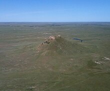
州西部の大半は草原で覆われ、サンダービュートなど多くのビュートが 点在している
サウスダコタ州は一般的に東部、西部およびブラックヒルズの3地域に分類される[38]。ミズーリ川が地形、社会および政治的な面で東部と西部の境になっている。西部にあるブラックヒルズは周辺とははっきり違う見た目の特徴で分類される。州民はブラックヒルズを西部に含め、ミズーリ川の西岸をウェストリバー、東岸をイーストリバーと呼ぶこともある[3][33]。
東部は概して西部よりも雨量が多く、低い地勢である。さらに小さく区分すれば、コトー・ド・プレーリー︵高原︶、開析漂礫土平原、およびジェームズ川流域がある。コトー・デ・プレーリーは東のミネソタ川から西のジェームズ川流域の間にある高原である[39]。その西はジェームズ川盆地であり、概して低く、平らで、深く浸食された土地であり、州内を南北に流れるジェームズ川に沿っている[40]。開析漂礫土平原はうねりのある丘陵と肥沃な土壌の地域であり、アイオワ州やネブラスカ州の大半からサウスダコタ州の南東隅に広がっている。約200万年前に始まる更新世に堆積した層が州東部の大半を覆っている[41]。州内には最も新しい岩と堆積物の層があり、漂礫土と呼ばれる大量の岩と土壌を堆積した氷河作用に続く期間に形成された[42]。

ブラックヒルズ、低い山地で州内南西部にある
グレートプレーンズは州内西側3分の2の大半を覆っている。ミズーリ川西岸では、より乾燥した岩の多い地形となり、うねりのある丘陵、平原、谷、および側面が急峻で頂上が平らなビュートと呼ばれる丘がある[43]。南部のブラックヒルズより東には悪地︵バッドランズ国立公園︶がある。ブラックヒルズから浸食されて出てきたもの、昔この地域を覆っていた大きな浅い海の底に積もった海洋性の岩石および火山噴出物が、この地域の地質を作った[41][44][45]。
ブラックヒルズは州内南西部にあり、ワイオミング州にも広がっている。この低い山地は標高6,000フィート (1,800 m) 級であり、麓からは2,000ないし4,000フィート (600 to 1,200 m) 立ち上がっている。ここには州内最高地点かつロッキー山脈より東側のアメリカ合衆国でも最高地点である標高7,242フィート (2.207 m) のハーニー峰がある[35]。20億年前の先カンブリア時代に形成されたものであり、最古の岩がブラックヒルズの中核を形成している[41][46]。それに続く古生代には外側の環状の地形が形成された[47]。これはおおまかに5億4,000万年から2億5,000万年前の時代に形成された。古代の内陸海の海岸であった時に堆積した石灰岩が見られる[47]。

ウインドケーブ国立公園のプロングホーン
ブラックヒルズをサウスダコタ州の大半は穏やかな草原型生物群系である。草原や耕作地が地域の大半を覆っているが、ハコヤナギ、ニレ、およびヤナギのような落葉樹が川の近くや防風林として見られる[48]。
哺乳類ではアメリカバイソン、シカ、プロングホーン、コヨーテ、およびプレーリードッグが生息している[49]。州鳥はコウライキジであり、中国から輸入されて地域に適応している[50]。ハクトウワシは生息数が増えており、特にミズーリ川近くで見られる[51]。草原にある川と湖では、ウォールアイ、コイ、キタカワカマス、バスなどの魚類が見られる[49]。ミズーリ川では先史時代のヘラチョウザメが見られる[52]。
ブラックヒルズは標高が高く降水量が多いので、その生態系は平原部とははっきり異なっている[53]。山地はポンデローサ・マツやロッジポール・マツ、さらにはトウヒなど松類で厚く覆われている[54]。哺乳類はシカ、アメリカアカシカ、ビッグホーン、シロイワヤギ、およびマウンテンライオンが生息し、水域ではマスの幾つかの種が見られる[54]。
地形と地質[編集]


生態系[編集]

気候[編集]
サウスダコタ州は大陸性気候にあり、四季がはっきりして、冷涼で乾燥した冬から暑くやや湿度の高い夏がある。夏季の平均最高気温は90°F (32℃) に迫ることも多いが、夜には60°F (16℃) 近くまで下がる。毎年夏には100°F (37℃) 超えて非常に暑く乾燥した日が続くことも多い。冬季は冷涼で、1月の平均最高気温は氷点下となり、最低気温は10°F (- 12 °C) 以下になる。過去最高気温は2006年7月15日にユースタで記録された120°F (49℃)[55]、過去最低気温は1936年2月17日にマッキントッシュで記録された-58°F (-50 ℃) である[56]。 年間平均降水量は亜乾燥の北西部で15インチ (381 mm)、やや湿潤な南西部で25インチ (635 mm) 程度であるが、ブラックヒルズのリードを中心とする小地域は30インチ (762 mm) 近くになって最大である[57]。 夏は強風と雷および雹を伴う雷雨になることが多い。州東部は竜巻街道に入っていると考えられる[58]。毎年平均30の竜巻に襲われている[59]。冬には吹雪や氷雨を伴う暴風といった厳しい気象条件もある。| サウスダコタ州の都市の月別平均最高最低気温(°F(℃)) | ||||||||||||
| 都市 | 1月 | 2月 | 3月 | 4月 | 5月 | 6月 | 7月 | 8月 | 9月 | 10月 | 11月 | 12月 |
|---|---|---|---|---|---|---|---|---|---|---|---|---|
| アバディーン | 21/1 (−6/-17) | 28/9 (−2/-13) | 40/21 (4/-6) | 57/33 (14/1) | 70/46 (21/8) | 79/55 (26/13) | 85/60 (29/16) | 84/57 (29/14) | 73/46 (23/8) | 59/34 (15/1) | 39/20 (4/-7) | 26/6 (−3/-14) |
| ラピッドシティ | 34/11 (1/-12) | 39/16 (4/-9) | 47/23 (8/-5) | 57/32 (13/0) | 67/43 (19/6) | 77/52 (25/11) | 86/58 (30/14) | 86/57 (30/14) | 75/46 (24/8) | 62/35 (17/2) | 45/22 (7/-6) | 36/13 (2/-11) |
| スーフォールズ | 25/3 (−4/-16) | 32/10 (0/-12) | 44/21 (7/-6) | 59/32 (15/0) | 71/45 (22/7) | 81/54 (27/12) | 86/60 (30/16) | 83/58 (28/14) | 74/48 (23/9) | 61/35 (16/2) | 42/21 (6/-6) | 29/8 (−2/-13) |
| [60] | ||||||||||||
国立公園と保護区[編集]

アメリカ合衆国国立公園局の管轄地域には以下が含まれる‥
●バッドランズ国立公園、1978年設立[61][62][63]
●ジュエルケーブ国立保護︵カスター近郊︶
●ルイス・クラーク国立歴史道
●ミニットマン・ミサイル国立歴史史跡︵南西部︶
●ミズーリ川国立レクリエーション河川
●ラシュモア山国立記念公園︵キーストーン近郊︶、1925年設立
●ウインドケーブ国立公園︵ホットスプリングス近郊︶、1903年設立
クレイジー・ホース記念碑はラシュモア山に近く、やはり山腹に大きな彫刻があるものであり、民間資金で建設された[64]。
人口動態[編集]

| 人口推移 | |||
|---|---|---|---|
| 年 | 人口 | %± | |
| 1860 | 4,837 | — | |
| 1870 | 11,776 | 143.5% | |
| 1880 | 98,268 | 734.5% | |
| 1890 | 348,600 | 254.7% | |
| 1900 | 401,570 | 15.2% | |
| 1910 | 583,888 | 45.4% | |
| 1920 | 636,547 | 9.0% | |
| 1930 | 692,849 | 8.8% | |
| 1940 | 642,961 | −7.2% | |
| 1950 | 652,740 | 1.5% | |
| 1960 | 680,514 | 4.3% | |
| 1970 | 665,507 | −2.2% | |
| 1980 | 690,768 | 3.8% | |
| 1990 | 696,004 | 0.8% | |
| 2000 | 754,844 | 8.5% | |
| 2010 | 814,180 | 7.9% | |
| 2020 | 886,667 | 8.9% | |
| July 1, 2010 Estimate | |||
人口[編集]
2020年国勢調査時点でのサウスダコタ州の人口は886,667人であり、2010年国勢調査時点より8.90%増加した[65]。
州民の7.3%が5歳未満、18歳未満では24%、65歳以上は14.3%とされている。女性が50.2%を占めている。2000年時点でアメリカ合衆国の50州の中では人口、人口密度共に第46位だった。
サウスダコタ州の人口重心はバッファロー郡ガンバレー付近にある[66]。
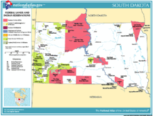
州内のインディアン居留地7か所︵桃色︶
インディアンは主にラコタ族、ダコタ族およびナコタ族︵スー族︶であり、幾つかの郡では人口の過半数を占め、またウェストリバーでは人口の20%になっている。
英語が州の﹁共通言語﹂として規定されている[1]。2000年時点で5歳以上の州民の1.90%が家庭でドイツ語を話し、1.51%はラコタ語またはダコタ語、1.43%はスペイン語を話している[69]。

18世紀末のスー族の勢力範囲︵緑色︶と、現在の保留地︵橙色︶
もともとこの地は、﹁グレート・スー・ネイション︵偉大なスーの国︶﹂として、西部で最大最強の略奪狩猟民族、スー族︵ダコタ族、ナコタ族、ラコタ族︶が領土としていた。現在も、同地で保留地︵Reservation︶を領有するインディアン部族はスー族のみである。
19世紀後半、この州でもインディアンと入植者の土地を巡る争いは苛烈を極め、アメリカ合衆国は﹁悪いインディアンのスー族﹂の制圧を﹁フロンティアの最後の主題﹂と位置づけた。米軍のウィリアム・テクムセ・シャーマン将軍は、﹁野蛮人のスー族は、年齢や男や女、子供の区別なく、一人残らず殺すべきならず者だ﹂として、徹底した掃討戦を行ったのである。
1968年にミネソタ州のオジブワ族が組織した、スラム育ちの若者たちによる﹁アメリカインディアン運動︵AIM︶﹂は、1970年代にアメリカ合衆国のインディアンに対する民族浄化政策に全米規模で反旗を翻した最大級の組織である。スー族は、このAIMに結成直後から参加共闘することとなった。AIM運動家でスポークスマンのラッセル・ミーンズは、AIM以前からのスー族権利回復運動の代表的なラコタ族インディアンとして知られる。また、合衆国によるキリスト教化に抗った伝統派の宗教者が多く、ジョン・ファイア・レイム・ディアーやマシュー・キング、レナード・クロウドッグといったスー族の長老宗教者たちは﹁インディアン寄宿学校﹂で伝統文化を奪われたAIMの若者たちに請われてインディアンの伝統儀式の指導を行い、1970年代の権利回復運動のなかの精神的支柱となると同時に、全米のインディアン部族の伝統宗教復活に尽力した。
オグララ・スー族は1973年の﹁ウンデッド・ニー占拠﹂の際に、また2007年にはラコタ・スー族が﹁ラコタ共和国﹂の独立国家宣言を行っている。
ヤンクトン・スー族は、アメリカ陸軍工兵司令部が保養地域として占領している二つの土地の、部族への返還を求めている。工兵司令部は2005年、この土地の所有権をサウスダコタ州に譲渡した。これに反対するヤンクトン・スー族は﹁アメリカインディアンの墓地の保護と遺物の返還法︵NAGPRA︶﹂に基づき、所有権譲渡無効を訴え、異議申し立てを行っている。2005年9月30日、連邦地方裁判所は、﹁この土地に関してスー族に実害は無く、連邦政府にはNAGPRAに基づく義務は生じない﹂と判定、スー族の訴えを却下した。ヤンクトン族は即時抗告している。
2010年1月、クロウクリーク・スー族部族会議は﹁エコテック燃料社︵EcoTech Fuels︶﹂と共同での、都市から排出されるゴミをガソリン燃料添加剤に変える計画のための、3900万ドル級の燃料生産プラントの誘致を満場一致で承認した。この工場は埋立廃棄物100トンあたりを200〜400バレルの燃料に変えるもので、純益の10%をクロウクリーク・スー族に、また職員、作業員合わせて40種の恒常的な定職をスー族部族員にもたらすものである。ブランドン・サズエル部族会議議長は、部族がベンチャー事業やエコテック連邦交付金の助成によって、利益分配はさらに上がると見込んでいる。また、﹁エコテック燃料社﹂はオグララ・スー族部族会議、ローズバッド・スー族とも養豚場の屎尿を原料とする新規計画を準備中である。
以下は同州でアメリカ連邦政府から公認されているスー族の保留地と部族会議、所属部族である。
人種と民族[編集]
2010年時点でサウスダコタ州の人種構成は以下の通りである。 ●84.7% 白人︵非ヒスパニック︶ ●1.2% 黒人 ●8.5% インディアン︵アメリカ合衆国本土で3番目に高い︶ ●0.9% アジア人 ●0.1% その他人種 ●1.8% 混血 ●2.7% ヒスパニック サウスダコタ州の5つの最大祖先グループは‥ドイツ系︵40.7%︶、ノルウェー系︵15.3%︶、アイルランド系︵10.4%︶、インディアン︵8.3%︶、イギリス系︵7.1%︶である[67]。ドイツ系アメリカ人は州の大部分で最大の構成比を示しており、特にイーストリバーで高い。幾つかの郡ではスカンディナヴィア系の子孫が最大構成比になっている。また1874年にヨーロッパから移住してきた再洗礼派集団であるヒュッテライトの人口は50州の中でも最も多い[68]。
人口成長と田園部の過疎化[編集]
サウスダコタ州はグレートプレーンズの他州と同様、過去数十年間にわたって田園部の多くで人口が減少している。これは﹁ルーラルフライト﹂︵過疎化︶と呼ばれ、家族農家が減少している。この傾向は近年も続き、州内30郡では1990年から2000年の間に人口が減少した[70]。この期間に9郡は10%以上減少しており、北西隅にあるハーディング郡の場合は19%にもなった[70]。低い出生率および若者が流入しないことで、これらの郡は中年世代の構成比が増加し続けている。24の郡では65歳以上の高齢者世代が少なくとも20%となっている。高齢者比率の全国平均は12.8%である。 しかし、過疎化は州全体に広がっているわけではない。田園部の郡と小さな町の大半の人口が減少したが、スーフォールズ市の周辺、州間高速道路29号に沿った大型郡、ブラックヒルズ、および多くのインディアン居留地は増加した[70]。スーフォールズ市に近いリンカーン郡の場合、アメリカ合衆国でも9番目に人口増加率の高い郡になっている。これらの地域の増加量が他の地域の減少量を補っており、州全体の人口増加率は全国平均よりも低いものの、着実に成長を続けている。宗教[編集]
サウスダコタ州住民の信じる宗派による構成比︵2001年︶は以下の通りである。 ●キリスト教 – 87% ●プロテスタント – 61% ●ルター派教会(アメリカ福音ルター派教会など) – 27% ●メソジスト – 13% ●バプテスト – 4% ●長老派教会 – 4% ●その他のプロテスタント – 6% ●無宗派 – 7% ●ローマ・カトリック – 25% ●他のキリスト教 – 1% ●他の宗教 – 3% ●無宗教 – 8% ●無回答 – 2%インディアン部族[編集]


|
≪ダコタ族≫
≪ダコタ・ナコタ族≫
|
≪ラコタ族≫ |
ララミー砦の条約と、「偉大なるスーの国」[編集]

同地のスー族は、アンドリュー・ジャクソン大統領の民族浄化政策である﹁インディアン移住法﹂による保留地への強制移住を最後まで拒絶した、アメリカ合衆国に対する19世紀西部のインディアン部族の最大反抗勢力だった。
西部に押し寄せる白人入植者の流れはもうだれにも止められず、カリフォルニア州の金の発見に伴う白人の幌馬車隊は、インディアンの保留地に入り込み、平原インディアンの命の糧であるバッファローを勝手に殺してインディアンの怒りを買うこととなった。
インディアン保留地では、内務省インディアン事務局︵BIA︶の白人監督官のサボタージュ、横領詐取が飢餓を生み、インディアンの不満は限界点に達していた。ユリシーズ・グラントは対西部インディアンの﹁和平委員会﹂を結成した。宣教師を中心とし、穏健派も交戦派も参加したこの﹁和平委員会﹂は、1868年にワイオミング準州ララミー砦で結ばれた﹁第二次ララミー砦条約﹂で、スー族の聖地ブラックヒルズ︵パハ・サパ︶周辺の全域を白人の立ち入りが許されない﹁スー族固有の不可侵の領土である﹂と盟約し、グレートスー居留地の設置を定めた。この際の条約の文言は、以下のようなあいまいなものだった。
﹁ブラックヒルズ一帯は、太陽が光り輝き、草が生えている間は、スー族のものである﹂
この文言にはまた、﹁インディアンがそれを返還することを望むまでは﹂という一文が書き添えられていた。このララミー砦条約は数年後に、対インディアン戦で悪名高かったカスター中佐がブラックヒルズで金鉱を発見すると、あっという間に破棄された。ブラックヒルズ近辺には白人が押し寄せ、﹁偉大なるスーの国﹂はたちまち白人入植者の圧力によって散り散りに分断されていった。スー族にとって﹁ララミー砦条約﹂を巡る法廷闘争は部族の主権に関わる、21世紀の今日に至っても係争中である譲れない重要事項である。

1868年の﹁第二次ララミー砦条約﹂で合衆国は﹁ミズーリ以 西のダコタ地方、ブラックヒルズ、プラット川とビッグホーン山脈間の土地を、永久に彼らに与える﹂と条約で保証した。桃色の枠線内全域が、条約で保証された本来の﹁偉大なるスーの国﹂である
1970年8月29日、マドンナ・サンダーホーク、マーサ・ファーストホース、マクシーン・ボルドーらスー族の女性運動家が﹁ララミー条約﹂に基づく権利として﹁ラシュモア山﹂とブラックヒルズのスー族による所有権の再確認、また﹁ラシュモア山﹂から﹁クレイジー・ホース山﹂への改名を求め、同山で座り込み抗議を行った。
1971年6月6日には、再びスー族による占拠が決行され、オグララ・スー族AIMのリーマン・ブライトマンやラッセル・ミーンズ、またレイム・ディアーら長老宗教者、インディアンの老若男女が1か月以上に渡って野営生活を行った。彼らは州や連邦と局の妨害をかわして同山頂上にAIMとスー族の旗を掲げ、﹁ブラックヒルズ一帯はスー族の領土である﹂との宣言を行った。この﹁ラシュモア山占拠﹂は全米に中継報道され、報道陣の前で、ラッセル・ミーンズらAIMスー族はワシントン像の頭に小便をかけてみせた。
1980年6月30日、連邦最高裁判所は半世紀にわたるスー族の訴えに対し、アメリカ政府による﹁ララミー砦条約﹂の違反と、﹁ラシュモア山﹂を含む﹁ブラックヒルズ﹂一帯の部族の占有権を認めた。しかし裁判所はこの土地の返還要求は却下し、1億ドルを超える賠償で応じる裁定を下した。スー族はこれを断固拒否している。
2009年8月29日、歴史的な﹁ラッシュモア山占拠﹂から39周年に当たるこの日、同山で再びインディアンによる大規模占拠が決行された。国連先住民会議の支援を受けたAIMや多数のインディアン団体による占拠隊は、バラク・オバマ大統領に対し、インディアンへの領土返還とスー族政治犯レナード・ペルティエの即時釈放を訴えた。
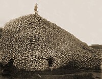
白人に駆逐されたバッファローの頭蓋骨の山︵1870年代︶。
スー族のホワイト・クラウド酋長はこう嘆いた。﹁白人が居ついてしまうとバッファローは必ずいなくなる。そして赤銅色の猟師たち︵インディアン︶は飢え死にすることになる﹂
1870年代以降、アメリカ合衆国政府はスー族を保留地に囲い込むために、国策として専門の猟師を西部に送り込み、スー族や平原インディアンが﹁兄弟﹂と崇め、彼らが命の糧とするバッファローの絶滅政策を採った。大陸横断鉄道の建設が大平原に始まるとバッファローの生態的移動経路が変えられ、さらに鉄道が完成すると、白人たちは車窓から手当たり次第にバッファローを射殺した。こうして平原のインディアンはますます飢えた。
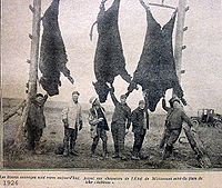
ミネソタ州では1926年に、最後の野生のバッファローが白人に殺さ れた
このような組織的な駆逐虐殺によって、19世紀初頭に数千万頭いたと推定されるバッファローは1890年にはわずか750頭になっていた。こうして食の道を断たれた完全狩猟民のスー族は、保留地でアメリカ政府の配給する食料に頼る生活を受け入れざるを得なくなった。突然狩猟文化を破壊され、農耕文化を強要されたスー族の社会は完全に崩壊した。そもそも同州の土地は農耕に不向きなため、現在でも彼らの保留地には産業といったものはほとんどない。

19世紀のバッファローの頭数の変遷
現在バッファローは、同州ではバッドランズ国立公園をはじめ、各地の国立公園で管理飼育されているが、限定した区画内での管理であるため、頭数制限のために毎年制限数を超えた数のバッファローが屠殺されている。また、渡りをおこなう動物であるバッファローは冬になると繁殖地に移動する性質があるが、イエローストーン国立公園では、この際周辺の白人農場に侵入したバッファローが、根拠の乏しいブルセラ病の病原説をとる白人農場主や州の管理官によって、毎年にわたって多数射殺されている。
こういった白人にとって余剰分となったバッファローを、インディアン部族が伝統的な自給自足の再獲得の理念をもって彼らの保留地に引き取り、その繁殖を図って﹁バッファロー牧場﹂を開設する試みが1980年代から本格化している。
なお、﹁バッファロー﹂はスイギュウ︵ウォーターバッファロー︶との混乱を避けるため近年﹁バイソン﹂と呼び換えられる動きもあるが、インディアンの間では﹁バッファロー牧場﹂や﹁インディアン・カジノ﹂の屋号など、現在でも﹁バッファロー﹂の呼称は普通に使われており、特にこだわりは見られない。この動物には本来、ブラックフット族なら﹁イーニー﹂、スー族なら﹁タタンカ﹂、コマンチ族なら﹁タシウォー﹂など、部族それぞれに呼び名がある。

全米最貧困地域[編集]
オグララ族、シチャング族の居住する同州の﹁パインリッジ・インディアン保留地﹂は、全米でも最貧困の地域として知られている。 同保留地の部族員の失業率は80%を超えており、また住宅事情も劣悪であり、どれも補修が必要なうえ、その1/3以上が水道や電気が未開通である。しかもこれらの家一軒につき平均して15人以上が住んでいて、それ以外の者たちは自家用車やトレーラーに住んでいる状況である。乳児の死亡率はアメリカ全国平均の3倍で、40歳以上の部族員の半分が糖尿病を患い、またアルコール依存症を抱えている。部族員であるオグララ族の一人あたりの所得は年間で約7000ドル︵全米平均の1/6未満︶である。若年層は、アメリカ軍への入隊以外、仕事の望みがほとんどなく、わずかな福祉小切手で暮らす毎日である。パイン・リッジ保留地での平均寿命は50歳である。 2010年1月15日にオバマ大統領は議会で、全国のインディアン部族の生活改善を誓約した。これに対し、オグララ・スー族部族会議議長テレサ・トゥー・ブルズはこうコメントしている。﹁アメリカの“向こう側の人達”は、私達の生活水準が第三世界のものだと気づきもしません。人々は、福祉施政やインディアン・カジノで私達が贅沢し、豚のように肥え太っていると思っています。私は、この保留地を扱うアメリカの議会の人達にこう言っています。どのように私達がここで生きていて、どういうわけでここに住んでいるのか、なぜ私達の子供が自殺するのか、その理由を自身で見つけ出してください。私達が誰なのかということを学んでください。﹂インディアンとバッファロー[編集]


バッファロー牧場と﹁ITBC﹂[編集]
同州のラピッドシティーには、﹁バッファロー牧場﹂の互助発展組織である非営利団体﹁ITBC︵部族相互野牛協同組合︶﹂の本部がある。 1991年2月、同州のブラックヒルズで、インディアンやエスキモーの漁猟狩猟権団体﹁NAFWS︵魚と野生動物のアメリカ先住民協会︶﹂の主催で、全米の﹁バッファロー牧場﹂の総合組織である﹁ITBC︵部族相互野牛協同組合︶﹂の第一回結成検討会議が開かれた。この会議に集まったのは、サウスダコタ州各地の保留地からスー族、モンタナ州からはクロウ族、ショーショーニー族、バンノック族、グロー・バントル族、アシニボイン族、ブラックフット族、ニューメキシコ州からは多数のプエブロ族、ネブラスカ州とウィスコンシン州からはウィンネバーゴ族、オクラホマ州からはチョクトー族、カリフォルニア州からはラウンド谷部族会議など、総勢19のインディアン部族だった。ITBCはこう述べている。﹁この中には、歴史的に敵同士だったものもあった。しかし今ここに、彼らは共通の任務のために結集したのだ﹂ 1991年6月、﹁NAFWS﹂の尽力によって、連邦議会からインディアン部族のバッファロー育成プログラムに基金が割り当てられ、これを基に12月に活動指針が決められ、組織作りが行われた。1992年4月、各部族代表がニューメキシコ州のアルバカーキで会議を開き、﹁ITBC﹂は公式のインディアン機関と認定され、役員の選定、会員資格、定款、および内規基準が決められた。こうして1992年の夏に、同州のラピッドシティーに﹁ITBC﹂の本部が置かれ、9月にはコロラド州で組織化された。 ﹁バッファロー牧場﹂が供給するバッファローの肉は、スローフードに沿う低カロリー食品として、多くのインディアンが抱える肥満・糖尿病に対策する伝統食として注目されており、各部族の健康センターでは部族民に対し、この肉の支給が行われている。彼らがバッファローを射殺する際には古式に則り、必ず呪い師が付き添い、大精霊に許しを乞う。こうして得られたバッファローの毛皮や皮は、伝統衣装や民芸品の復興にも役立てられ、また肉や各種製品はアメリカ内外にもリリースされている。 現在﹁ITBC﹂は非営利団体として57部族が会員資格を持ち、上記された7つの州に加え、オレゴン州、ワシントン州、アリゾナ州、アイダホ州、ユタ州、コロラド州、ミシガン州、ミネソタ州、ワイオミング州、カンザス州、ノースダコタ州、またアラスカ州の合計19の州のインディアン部族を傘下としている。これらの州のインディアン保留地の﹁バッファロー牧場﹂では現在、総合して15000頭以上のバッファローが飼育されており、インディアン以外の団体にも提携を拡げている。またバッファローの生態データの統計、観光資源活用、野生動物としての社会啓蒙、﹁大草原の復活提案﹂など、活動内容は多岐に渡っている。インディアン・カジノ[編集]
サウスダコタ州でのインディアン・カジノは、すべてスー族によって運営されている。営業実績は隣州ミネソタ州の﹁シャコペー・ムデワカントン・スー族﹂の﹁ミスティック湖畔カジノホテル﹂に大きく差をつけられており、﹁シャイアン川スー族﹂部族会議は現在、保留地外の州中央部のオアヘ湖畔での部族カジノ開業を計画している。 2008年7月、﹁シャイアン川スー族﹂が大きな期待を寄せるこの国境外部族カジノ計画についてサウスダコタのマイク・ラウンズ知事は﹁聞いていない﹂とコメントした。ラウンズ知事はインディアン部族による保留地外でのカジノ開設案に反対しており、先行きは不透明である。
|
|
主要な都市[編集]

サウスダコタ州内の市域人口1万人以上の都市を下記に列挙する。都市名にある括弧内数字は2020年時点の人口を示す[65]。
(一)スーフォールズ (192,517)
(二)ラピッドシティ (74,703)
(三)アバディーン (28,495)
(四)ブルッキングズ (23,377) - サウスダコタ州立大学の所在地
(五)ウォータータウン (22,655)
(六)ミッチェル (15,660)
(七)ヤンクトン (15,411)
(八)ヒューロン (14,263) - サウスダコタ・ステート・フェアの開催地
(九)ピア (14,091) - 州都
(十)スピアフィッシュ (12,193)
(11)ボックスエルダー (11,746)
(12)バーミリオン (11,695) - サウスダコタ大学の所在地
(13)ブランドン (11,048)
関連項目‥en:List of cities in South Dakota、サウスダコタ州の郡一覧
スーフォールズの人口は2020年時点で約19万人であり、州内最大である。その都市圏は人口276,340人を数える[65]。スーフォールズ市は1856年に設立された。位置的には州の南東隅にある[71]。元々は農業と採石業で始まったが、現在では小売業、金融業および医療が重要な産業になっている[72]。
州西部の中心都市であるラピッドシティは2020年時点の人口が約7.5万人であり、州内第2の都市である。都市圏の人口は139,074人、スピアフィッシュ小都市圏をあわせた広域都市圏の人口は164,842人である[65]。ブラックヒルズの東縁にあり、1876年に設立された[73]。ラシュモア山をはじめとするブラックヒルズ観光の拠点であることと、エルスワース空軍基地にも近いことで、その地域経済は観光業と防衛費・軍需産業に基づいている[72]。
スーフォールズ都市圏とラピッドシティ広域都市圏の2つだけで、その人口の合算は441,182人となり、州の総人口のおよそ半分に達する。
アバディーンが第3の都市であり、人口は約2.8万人、小都市圏では42,287人である[65]。州北東隅にあり、ミルウォーキー鉄道が延伸されてきた1881年に設立された。
州都ピアは人口約1.4万人で、州内では9位である。全米50州の州都の中では、バーモント州モントピリア︵8,074人[65]︶に次いで人口が少ない。ピア小都市圏の人口は19,988人である[65]。
行政と法律[編集]
詳細は「w:Government of South Dakota」を参照

政府[編集]
サウスダコタ州政府は、アメリカ合衆国や他の州と同様、行政、立法、及び司法の三権が分立している。州政府の構造は州の最高法である州憲法に規定されており、憲法を修正するときは、議会両院の多数が賛成するか、住民発議での賛成を必要とする[74]。
州知事が行政府の長である[75]。現在の知事は、共和党クリスティ・ノームである。州憲法では議会で承認された法に対し、州知事は署名して法にするか、拒否権を発動する権限が認められている[76]。また州軍の総司令官、閣僚の指名、有罪となった者に対する刑の執行あるいは恩赦を与える権限がある[77]。州知事の任期は4年間であり、連続2期を超えて就任することはできない[78]。
議会は州上院35名並びに州下院70名の議員で構成されている。サウスダコタ州は35選挙区で構成されており[79]、それぞれ2人の下院議員と1人の上院議員を選出する[79]。議会の会期は毎年1月第2火曜日に始まり、30日間続く。州知事が特別会期を招集できる[79]。
司法府は数段階ある。州最高裁判所は4人の判事と1人の首席判事がおり、州内では最高位にある[80]。その下には巡回裁判所があり、38人の判事が7つの司法区を回っている。さらにその下には軽犯罪や民事を扱う地方裁判所がある[80]。
連邦議会議員[編集]
サウスダコタ州は連邦議会に上院議員2人、下院議員1人を送り出している。2024年時点で全員が共和党員である。下院議員を1人しか選出できない﹁全州︵選挙︶区﹂︵“At-large district”︶州はアメリカ国内に6つあり、サウスダコタ州はその1つである[81][注 1]。近年は、インディアン︵いわゆる﹁アメリカ・インディアン﹂﹁ネイティブ・アメリカン﹂と呼ばれる人々︶が州や郡のレベルで政治・選挙運動により活発に参加するようになってきており、その効果・影響は選挙でもしばしば表れている。例えば、2002年の中間選挙時に実施された上院議員選挙では、民主党の現職だったティム・ジョンソンが共和党の対立候補だったジョン・スーン連邦下院議員を得票率にして0.15%、得票数にして532票という僅差の大接戦を制して辛勝、再選を果たしているが、このジョンソンの勝利の背景にはインディアン票の獲得があったとされる[82][注 2]。
大統領選挙では、選挙人数3人が割り当てられている︵全国で538人︶[83]。選挙人は総取り方式である[84]。
政治[編集]
| 年 | 共和党 | 民主党 |
|---|---|---|
| 2008年 | 54.30% 203,019 | 45.70% 170,886 |
| 2004年 | 59.91% 232,584 | 38.44% 149,244 |
| 2000年 | 60.3% 190,700 | 37.56% 118,804 |
| 1996年 | 46.49% 150,543 | 43.03% 139,333 |
| 1992年 | 40.66% 136,718 | 37.14% 124,888 |
| 1988年 | 52.85% 165,415 | 46.51% 145,560 |
| 1984年 | 63.0% 200,267 | 36.53% 116,113 |
サウスダコタ州の政治は概して共和党が支配している。大統領選挙では1964年以来民主党候補を支持したことが無く、1972年大統領選挙の民主党候補ジョージ・マクガヴァンはサウスダコタ州出身だったが、この州を制することができなかった[85][86]。また州知事選挙でも民主党は1978年以降勝利していない。2006年時点では共和党の有権者登録が民主党のそれを10%以上上回っており[87]、州議会では両院ともに多数派となった[88][89]。
州内の当面の問題は州営宝くじの費用と利益に関するものである[90]。また教育費特に教師の給与が比較的低いこと、および人工中絶の禁止に関わることも問題になっている[91][92]。

エルズワース空軍基地から離陸するB-1B ランサー、基地は州内最 大級の雇用主である
アメリカ合衆国商務省経済分析局によると、サウスダコタ州の州総生産高は2010年に398億米ドルであり、国内では46位である[93]。一人当たりの収入は2010年に38,865米ドルであり、合衆国内で第25位だった[94]。2008年で、人口の12.5%は貧困線以下である[95]。
CNBCによる﹁2010年事業に好適な州﹂リストでは、サウスダコタ州が7位になった[96]。2011年7月時点の失業率は4.7%だった[97]。
州内ではサービス産業が最大の産業区分である。この分野には小売業、金融業および医療分野が含まれる。一時期国内最大の金融持株会社だったシティバンクが1981年にサウスダコタ州で全国的な金融操作を始めたが、これはサウスダコタ州が銀行業に有利な規制を敷いていることを生かしたものである[29]。連邦政府の支出も州経済に大きな比率を占めており、州総生産の10%以上になっている。ラピッドシティに近いエルズワース空軍基地は州内第2位の雇用主である[98]。
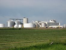
ターナー郡のエタノール工場
昔から農業がサウスダコタ州経済の重要部分を占めていた。近年他の産業が急速に拡大してきたが、州内の特に田園部では農業生産が経済の重要な要素である。産品としては牛、トウモロコシ、大豆、小麦、豚がある[99]。食肉加工やエタノールなど農業関連の産業もかなりの影響力を持つようになった。エタノールの生産量では国内第6位である。
もう一つの重要な産業は観光業である。ブラックヒルズの歴史ある町デッドウッドやラシュモア山、さらに付近の国立公園や州立公園などが特に多くの観光客を呼ぶ観光地になっている。州内で最大級の観光行事はスタージス・モーターサイクル・ラリーである。5日間にわたって開催された2006年では45万人以上の観客を呼んだ。この数字は州人口が80万人ほどであることを考慮すれば、かなりのものである[100]。観光業によって2006年時点では33,000人を雇用し、20億ドル以上の経済効果があったと推計されている[101]。
経済[編集]


タックスヘイブン[編集]
サウスダコタ州の信託は、元配偶者や不満を抱いたビジネスパートナー、債権者、訴訟クライアントといった人々の請求から資産を保護する [102]。州税[編集]
2005年時点で、サウスダコタ州の一人当たり州税率は国内最低である[103]。個人や法人の所得税[104]、相続税[105]、あるいは無形資産税は徴収していない。消費税率は4%である。地方自治体などによって独自の加算が行われるので、6%を徴収するところもある。消費税はインディアン居留地に住むインディアンには適用されないが、多くの居留地は州と盟約を結んでいる。居留地内の企業は税を徴収し、郡内あるいは関連する地域に住む総人口に対するインディアン人口の比率に応じて、州はインディアン部族に還付金を戻している。従価資産税は地方税であり、教育学区、郡、自治体など地方政府にとって大きな財源になっている。サウスダコタ州特別税地区がたばこや酒類に関わる税などいくつかの税を規制している[106]。交通[編集]
詳細は「w:Transportation in South Dakota」を参照

州内には高規格道路、道路および通りを合わせて83,609マイル (133,774 km) と、州間高速道路679マイル (1,086 km) が走っている[107]。州間高速道路では、州南部を東西に走る90号線と、東部を南北に走る29号線の2つの幹線がある。29号線の走る地域は東部の他地域よりも高い人口増加率と経済成長率が記録され、それがまた州間高速道路で加速されている[70]。その他に短い州間高速道路もある。ラピッドシティ中心部に入る支線の190号線、スーフォールズの東部と南部を回る環状の229号線である。アメリカ国道では、12号線、14号線、16号線、18号線および212号線が東西に走り、81号線、83号線、85号線、および281号線が南北に走っている。サウスダコタ州とモンタナ州の間には国内唯一の州を跨ぐ未舗装路がある。
州内には2本の国立景観側道がある。ピーター・ノーベック国立景観側道はブラックヒルズにあり、ネイティブ・アメリカン景観側道は州北中部のミズーリ川沿いにある。その他の景観側道として、バッドランズ・ループ景観側道、スピアフィッシュ・キャニオン景観側道、ワイルドライフ環状道路景観側道がある[108]。
鉄道は19世紀半ば以来州内交通で重要な役割を果たしてきた。19世紀から20世紀初期にかけて、4,420マイル (7,072 km) の鉄道が建設されたが、現在では1,839マイル (2,942 km) しか使われていない[109]。BNSF鉄道が州内では最大の鉄道運行会社である。他の幹線運行会社として、ダコタ・ミネソタ・アンド・イースタン鉄道がある[110][111]。州内の鉄道は貨物輸送に限られており、ワイオミング州と並んでアムトラックの運行が無い数少ない州の1つになっている[112]。
乗降客数で州内最大の空港はスーフォールズ地域空港とラピッドシティ地域空港である。デルタ航空、フロンティア航空、アレジアント航空、さらにコミューター路線が主要航空会社と提携してこれら空港を使用している。他の都市でも商業便が運行されており、その中にはエッセンシャル・エアサービスで委託したものがある[113]。
教育[編集]

2006年時点で、サウスダコタ州の一次および二次教育を受ける生徒児童の総数は136,872人であり、このうち120,278人は公共教育を受けている[114]。168の教育学区[115]に703の公立学校があり[116]、一人当たりの学校数では国内最大になっている[117]。高校卒業率は89.9%であり[118]、大学進学試験の結果は国内平均21.1点を僅かに上回る21.8点である[119]。成人人口の84.6%は少なくとも高校卒であり、21.5%は学士以上の学位を得ている[67]。
2008年時点で、公立学校教師の給与は年36,674米ドルであり、国内平均の52,308米ドルより低く、国内最下位となっている[120]。
単科及び総合大学[編集]
州知事が指名した理事で構成されるサウスダコタ州理事会が州内6つの公立大学を管理している。ブルッキングス市にあるサウスダコタ州立大学が州内最大の大学であり、学生数は12,376人である[121]。バーミリオン市のサウスダコタ大学は州内最古の大学であり、州内唯一の法科大学かつ医科大学である[122]。州内にはいくつかの私立大学もあり、そのうちの最大はスーフォールズ市にあるオーガスタナ大学である[121]。- オーガスタナ大学、スーフォールズ市
- ブラックヒルズ州立大学
- ダコタ州立大学
- ダコタ・ウェスレアン大学
- ヒューロン大学(2005年閉校)
- マウント・マーティ・カレッジ
- ナショナル・アメリカン大学
- ノーザン州立大学
- オグララ・ラコタ・カレッジ
- プレゼンテーション・カレッジ
- シント・グレスカ大学
- サウスダコタ工業工科学校
- サウスダコタ州立大学
- スーフォールズ大学
- サウスダコタ大学
- USDSU
- ヤンクトン・カレッジ(1984年閉校)
文化[編集]
詳細は「w:Culture of South Dakota」を参照

サウスダコタ州の文化は州内のインディアン、田園部、アメリカ合衆国西部およびヨーロッパの文化を反映している。デッドウッド市のデイズ・オブ'76[123]、テイバーのチェコの日[124]、およびスーフォールズ市のセントパトリックデイやシンコ・デ・マヨ祭のような多くの年中行事は州内の民族と歴史の遺産を祝っている。州全体で多くのパウワウが毎年開催され[125]、カスター州立公園のバッファロー・ラウンダップでは、乗馬のボランティアが州内のバッファロー約1,500頭を集める。
ローラ・インガルス・ワイルダーの半自叙伝的小説はフロンティアでの子供時代や青年時代の経験を反映したものであり、州内では知名度の高い作家である。﹃シルバー・レイクの岸辺で﹄、﹃長い冬﹄、﹃大草原の小さな家﹄、﹃この楽しき日々﹄および﹃はじめの四年間﹄では、デスメットに近い農場で育った経験が使われている。その娘ローズ・ワイルダー・レーンも良く知られた作家であり、1886年にデスメット近くで生まれた。もう一人の作家としてブラック・エルクがおり、インディアン戦争やゴーストダンス運動についての語りやインディアン宗教についての思想が著作﹃Black Elk Speaks﹄の元になっている[126]。コールデコット賞などを受賞した児童文学者でイラストレーターのポール・ゴーブルは1977年以降ブラックヒルズに住み、インディアンの文化を世界中の子供達に紹介している[127]。
著名な芸術家も幾人かいる。ハーヴィー・ダンは19世紀にマンチェスター近くの農園で育った。その経歴の大半はイラストレーターであるが、その最も有名な作品は生涯の終わり近くなって完成したフロンティア生活の情景である[128]。ヤンクトネイ・ダコタ族出身のオスカー・ハウはクロウクリーク・インディアン居留地で生まれ、その水彩画で有名になった[129]。伝統的な様式の絵画に対抗して抽象画の影響を強く受けた作品を描いたインディアンとしては最初期の画家である。テリ・レッドリンはウォータータウンの出身であり、田園部や野生生物の絵で著名になった。レッドリンの作品の多くがウォータータウンのレッドリン美術会館に展示されている[130]。
スポーツチーム[編集]
- ラピッドシティ・フライングエースズ - インドアフットボール, National Indoor Football League
- スーフォールズ・カナリーズ - 野球, アメリカン・アソシエーション
- スーフォールズ・スカイフォース - バスケットボール, NBAデベロップメントリーグ
- スーフォールズ・スピットファイア - サッカー, USLプレミアデベロップメントリーグ
- スーフォールズ・ストーム - アリーナフットボール, Indoor Football League
その他[編集]
サウスダコタ州出身の有名人[編集]
- サウスダコタ州出身の有名人(英文)
- スパーキー・アンダーソン - 野球選手・監督 (アメリカ野球殿堂表彰者)
- ヒューバート・ハンフリー - 第38代アメリカ合衆国副大統領
- ジョージ・マクガヴァン - 政治家
- マーク・エリス - 野球選手
州の象徴など[編集]
- 州の鳥 - コウライキジ
- 州の魚 - ウォールアイ
- 州の花 - セイヨウオキナグサ
- 州の木 - ブラックヒルズトウヒ
- 州のモットー - "Under God, the people rule"
- 州のスローガン - Great Faces. Great Places.
- 州の愛称 - 「ラシュモア山の州」(公式)、「コヨーテ州」「サンシャイン州」(非公式
- 州の鉱物 - ローズクォーツ
- 州の昆虫 - セイヨウミツバチ
- 州の動物 - コヨーテ
- 州の宝石 - フェアバーンメノウ
- 州の歌 - "Hail, South Dakota!"
日本の姉妹都市[編集]
脚注[編集]
注釈[編集]
出典[編集]
(一)^ ab“South Dakota Codified Laws (1–27–20)”. South Dakota State Legislature. 2010年4月27日閲覧。
(二)^ “South Dakota recognizes official indigenous language”. Template:Cite webの呼び出しエラー‥引数 accessdate は必須です。
(三)^ abcHasselstrom, pp. 2–4.
(四)^ MLA Language Map Data Center". Modern Language Association.
(五)^ Schell, p. 15.
(六)^ Deloria and Neal (eds.), p. 161.
(七)^ Schell, pp. 16–18.
(八)^ Schell, pp. 28–29.
(九)^ Schell, pp. 18–21.
(十)^ Thompson (ed.), pp. 56–57.
(11)^ abc“Chronology of South Dakota History”. South Dakota Historical Society. 2007年9月1日時点のオリジナルよりアーカイブ。2007年9月3日閲覧。
(12)^ Thompson (ed.), pp. 69–71.
(13)^ Schell, pp. 72–73.
(14)^ Schell, p. 72.
(15)^ “Dakota Territory History”. Union County Historical Society. 2007年9月3日閲覧。
(16)^ Schell, pp 168–170.
(17)^ Schell, p. 113.
(18)^ Schell, p. 129.
(19)^ Schell, pp. 140–144.
(20)^ Thompson (ed.), p. 529.
(21)^ Schell, p. 222.
(22)^ Thompson (ed.), pp. 115–116.
(23)^ “Coin of the Month”. The United States Mint. 2007年8月19日閲覧。
(24)^ “North Dakota's Boundaries”. North Dakota Geological Survey (2002年). 2007年8月19日閲覧。
(25)^ abSchell, pp. 304–305.
(26)^ “Population of Counties by Decennial Census:1900 to 1990”. United States Census Bureau. 2008年12月14日閲覧。
(27)^ Schell, pp. 317–320.
(28)^ abSchell, pp. 323–325.
(29)^ abHetland, Cara. Sioux Falls 25 years after Citibank's arrival. Publicradio.org Minnesota Public Radio. February 24, 2006. (accessed March 23, 2007)
(30)^ “Homestake Strikes Gold Again”. South Dakota Science and Technology Authority. 2007年8月28日閲覧。
(31)^ Thompson (ed.), pp. 542–549.
(32)^ Census Regions and Divisions of the United States, U.S. Census Bureau. Retrieved January 29, 2009.
(33)^ abJohnson, Dirk. Gold Divides Dakotans as River Did NYtimes.com The New York Times. October 9, 1988. (accessed 2008-2-14)
(34)^ “Land and Water Area of States (2000)”. infoplease.com. 2007年9月3日閲覧。
(35)^ abc“Elevations and Distances in the United States”. United States Geological Survey (2005年4月29日). 2006年11月7日閲覧。
(36)^ Garcia-Castellanos, D.; U. Lombardo (2007). “Poles of Inaccessibility:A Calculation Algorithm for the Remotest Places on Earth”. Scottish Geographical Journal 123 (3): 227-233. doi:10.1080/14702540801897809 2011年6月3日閲覧。.
(37)^ “Eastern South Dakota Wetlands”. United States Geological Survey. 2009年1月25日閲覧。
(38)^ Thompson (ed.), p. 14.
(39)^ Thompson (ed.), pp. 17–18.
(40)^ Schell, pp. 4–6.
(41)^ abc“The Geology of South Dakota”. Northern State University. 2008年8月29日閲覧。
(42)^ “Pleistocene Deposits”. South Dakota Department of Environment & Natural Resources. 2008年11月28日閲覧。
(43)^ Schell, p. 6.
(44)^ “Mesozoic Formations”. South Dakota Department of Environment & Natural Resources. 2008年11月28日閲覧。
(45)^ “Tertiary Formations”. South Dakota Department of Environment & Natural Resources. 2008年11月28日閲覧。
(46)^ “Precambrian Formations”. South Dakota Department of Environment & Natural Resources. 2008年11月28日閲覧。
(47)^ ab“Paleozoic Formations”. South Dakota Department of Environment & Natural Resources. 2008年11月28日閲覧。
(48)^ “South Dakota Flora”. Northern State University. 2007年9月22日閲覧。
(49)^ ab“South Dakota Fauna”. Northern State University. 2007年9月22日閲覧。
(50)^ “Ring-Necked Pheasant”. Northern State University. 2007年9月22日閲覧。
(51)^ Hetland, Cara. South Dakota bald eagles make a comeback Publicradio.org Minnesota Public Radio. February 8, 2007. (accessed September 22, 2007).
(52)^ “Paddlefish”. Northern State University. 2007年9月22日閲覧。
(53)^ South Dakota's Forest Resources. Piva, R.;Haugan, D.;Josten, G.;Brand, G. (U.S. Department of Interior. Forest Service Resource Bulletin. 2007)
(54)^ abThompson (ed.), p. 31.
(55)^ “Each state's high temperature record”. USA Today. 2012年3月1日閲覧。
(56)^ “Each state's low temperature record”. USA Today. 2012年3月1日閲覧。
(57)^ “Precipitation Normals (1971–2000)”. South Dakota State University. 2008年11月26日閲覧。
(58)^ “Tornado Climatology”. National Severe Storms Laboratory. 2009年2月7日閲覧。
(59)^ “Annual Average Number of Tornadoes, 1953–2004”. National Climatic Data Center. 2009年6月25日閲覧。
(60)^ South Dakota Weather|South Dakota Weather For Travellers and Residents
(61)^ “Frequently Asked Questions (Badlands National Park)”. National Park Service. 2007年8月27日閲覧。
(62)^ “Badlands”. National Park Service. 2007年8月27日閲覧。
(63)^ “South Dakota”. National Park Service. 2007年8月28日閲覧。
(64)^ Hetland, Cara. Crazy Horse Memorial turns 60 this year Publicradio.org Minnesota Public Radio. June 8, 2008. (accessed February 7, 2009).
(65)^ abcdefgQuickFacts. U.S. Census Bureau. 2020年.
(66)^ “Population and Population Centers by State – 2000”. United States Census Bureau. 2007年8月18日閲覧。
(67)^ ab“Quick Tables”. United States Census Bureau. 2008年8月29日閲覧。
(68)^ “Color them plain but successful”. The Federal Reserve Bank of Minneapolis. 2008年12月14日閲覧。
(69)^ “Most Spoken Languages in South Dakota”. mla.org. 2007年8月18日閲覧。
(70)^ abcdO'Driscoll, Patrick. "Sioux Falls powers South Dakota growth", USA Today, March 12, 2001. (accessed December 16, 2008)
(71)^ “History of Sioux Falls”. City of Sioux Falls. 2008年10月6日閲覧。
(72)^ abThompson (ed.), p. 554.
(73)^ Hasselstrom, p. 331.
(74)^ “Article XXIII, Section 1, Constitution of South Dakota”. South Dakota Legislature. 2008年11月26日閲覧。
(75)^ “Article IV, Section 1, Constitution of South Dakota”. South Dakota Legislature. 2008年11月26日閲覧。
(76)^ “Article IV, Section 3, Constitution of South Dakota”. South Dakota Legislature. 2008年11月26日閲覧。
(77)^ “Article IV, Section 4, Constitution of South Dakota”. South Dakota Legislature. 2008年11月26日閲覧。
(78)^ “Article IV, Section 2, Constitution of South Dakota”. South Dakota Legislature. 2008年11月26日閲覧。
(79)^ abc“Fact Sheet”. State of South Dakota. 2008年11月26日閲覧。
(80)^ ab“Overview – UJS”. South Dakota Unified Judicial System. 2010年1月30日閲覧。
(81)^ “Member Information”. Office of the Clerk – United States House of Representatives. 2009年4月5日閲覧。
(82)^ Gwen Florio, "Indians Show Political Clout;Natives Throng Polls in 'White' S.D. County," The Denver Post, January 8, 2003, accessed June 8, 2011
(83)^ “U.S. Electoral College – 2008 Presidential Election”. archives.gov. 2008年12月15日閲覧。
(84)^ “U.S. Electoral College – Frequently Asked Questions”. archives.gov. 2008年12月15日閲覧。
(85)^ “McGovern, George Stanley, (1922–)”. Biographical Directory of the United States Congress. 2007年10月5日閲覧。
(86)^ “Presidential General Election Graph Comparison – South Dakota”. uselectionatlas.org. 2007年10月5日閲覧。
(87)^ “South Dakota Voter Registration Statistics”. South Dakota Secretary of State. 2007年4月10日閲覧。
(88)^ “Official List of South Dakota Representatives”. State of South Dakota. 2007年4月10日閲覧。
(89)^ “Official List of South Dakota Senators”. State of South Dakota. 2007年4月10日閲覧。
(90)^ “About SD Lottery – History”. South Dakota Lottery. 2009年6月26日閲覧。
(91)^ “South Dakota Abortion Ban Rejected”. USA Today. (2006年11月8日) 2008年12月14日閲覧。
(92)^ Rovner, Julie. South Dakotans Again Consider An Abortion Ban [1] National Public Radio. October 27, 2008. (accessed August 13, 2009).
(93)^ “Table 3. Current-Dollar GDP by State, 2007–2010”. Bureau of Economic Analysis. 2011年8月25日閲覧。
(94)^ “SA1-3 Per capita income (dollars)”. Bureau of Economic Analysis. 2011年8月25日閲覧。
(95)^ “Persons Below Poverty Level, 2008”. United States Census Bureau. 2011年8月25日閲覧。
(96)^ America's Top States for Business 2010." CNBC Special Report (2010):1. Web. May 9, 2011. <http://www.cnbc.com/id/37516043/>.
(97)^ “Local Area Unemployment Statistics”. Bureau of Labor Statistics. 2011年5月9日閲覧。
(98)^ Reha, Bob. South Dakota's Ellsworth AFB to stay open. [2] Minnesota Public Radio. August 26, 2005. (accessed September 8, 2007)
(99)^ “State Fact Sheets:South Dakota”. United States Department of Agriculture. 2009年6月25日閲覧。
(100)^ “Sturgis Rally Attendance Statistics”. sturgis.com. 2007年4月6日閲覧。
(101)^ “South Dakota Tourism Statistics”. South Dakota Department of Tourism. 2007年4月6日閲覧。
(102)^ “世界最強のタックスヘイブンとして超富裕層たちに愛される土地とは?”. (2019年11月19日) 2021年10月7日閲覧。
(103)^ “States Ranked by Total State Taxes and Per Capita Amount:2005”. U.S. Census Bureau. 2007年4月4日閲覧。
(104)^ “South Dakota”. The Tax Foundation. 2010年1月31日閲覧。
(105)^ “Inheritance/Estate Tax”. South Dakota Department of Revenue & Regulation. 2008年1月27日閲覧。
(106)^ South Dakota Department of Revenue & Regulation. “Special Tax Information”. 2008年3月18日閲覧。
(107)^ “General Information/Key Facts”. South Dakota Department of Transportation. 2007年9月3日閲覧。
(108)^ “South Dakota”. National Scenic Byways Program. 2008年1月24日閲覧。
(109)^ “Basic Mileage”. South Dakota Department of Transportation. 2007年9月3日閲覧。
(110)^ “BNSF”. South Dakota Department of Transportation. 2007年9月3日閲覧。
(111)^ “DM&E”. South Dakota Department of Transportation. 2007年9月3日閲覧。
(112)^ “Planning a Trip”. frommers.com. 2007年9月3日閲覧。
(113)^ “What is Essential Air Service?” (PDF). United States Department of Transportation. 2008年12月13日閲覧。
(114)^ “Student Demographics”. South Dakota Department of Education. 2007年11月8日時点のオリジナルよりアーカイブ。2007年11月26日閲覧。
(115)^ “Schools & Personnel”. South Dakota Department of Education. 2007年11月8日時点のオリジナルよりアーカイブ。2007年11月26日閲覧。
(116)^ “School System By Type (2006–07)”. South Dakota Department of Education. 2007年11月8日時点のオリジナルよりアーカイブ。2007年11月26日閲覧。
(117)^ “Number of Schools (most recent) (per capita)”. statemaster.com. 2007年11月26日閲覧。
(118)^ “South Dakota Graduation Rate”. South Dakota Department of Education. 2007年11月8日時点のオリジナルよりアーカイブ。2007年11月26日閲覧。
(119)^ “ACT Average Composite Score South Dakota vs. National”. South Dakota Department of Education. 2007年11月8日時点のオリジナルよりアーカイブ。2007年11月26日閲覧。
(120)^ “Rankings and Estimates 2008”. National Education Association. 2010年1月30日閲覧。
(121)^ ab“Regents Information System”. South Dakota Board of Regents. 2010年7月20日閲覧。 [リンク切れ]
(122)^ “Locations”. South Dakota Board of Regents. 2008年7月13日時点のオリジナルよりアーカイブ。2010年4月18日閲覧。
(123)^ “Days of '76 Celebration to include Saturday evening performance”. Tri-State Livestock News. 2010年1月29日閲覧。
(124)^ Thompson (ed.), p. 133.
(125)^ “South Dakota Powwow Schedule”. South Dakota Office of Tribal Government Relations. 2010年1月29日閲覧。
(126)^ “Black Elk”. C-Span – American Writers. 2008年12月19日閲覧。
(127)^ “Paul Goble”. HarperCollins. 2010年1月17日閲覧。
(128)^ Hasselstrom, pp. 34–36.
(129)^ Hasselstrom, pp. 215–217.
(130)^ “Terry Redlin”. South Dakota Hall of Fame. 2009年5月11日閲覧。
参考文献[編集]
- Hasselstrom, Linda M. (1994). Roadside History of South Dakota. Missoula, MT: Mountain Press Publishing Company. ISBN 0878422625
- Schell, Herbert S. (2004). History of South Dakota. Pierre, SD: South Dakota State Historical Society Press. ISBN 0971517134
- Thompson, Harry F. (ed.) (2009). A New South Dakota History (Second ed.). Sioux Falls, SD: Center for Western Studies – Augustana College. ISBN 978-0-931170-00-3
- Lauck, Jon K. Prairie Republic:The Political Culture of Dakota Territory, 1879–1889 (University of Oklahoma Press;2010) 281 pages
- Wishart, David J. ed. Encyclopedia of the Great Plains, University of Nebraska Press, 2004, ISBN 0-8032-4787-7. complete text online;900 pages of scholarly articles
関連項目[編集]
外部リンク[編集]
- 公式ウェブサイト
- South Dakota Tourism (英語)
- 在シカゴ日本国総領事館
- South Dakota State Databases – Annotated list of searchable databases produced by South Dakota state agencies and compiled by the Government Documents Roundtable of the American Library Association.
- Energy Profile for South Dakota
- USGS real-time, geographic, and other scientific resources of South Dakota
- U.S. Census Bureau
- South Dakota State Facts
- South Dakota State Historical Society Press Books and journals published by the State Historical Society
- サウスダコタ州 - Curlie(英語)
 サウスダコタ州に関連する地理データ - オープンストリートマップ
- 地図 - Google マップ
| 全般 |
|
|---|---|
| 国立図書館 |
|
| 地理 |
|
| その他 |
|