
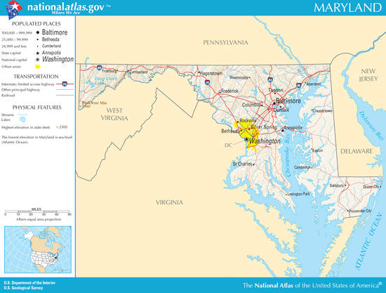
メリーランド州
- メリーランド州
- State of Maryland
-


(州旗) (州章) - 州の愛称: 伝統ある州
Free State, Old Line State - 州のモットー: 強い行動、優しい言葉
イタリア語: Fatti maschii, parole femine 
-
州都 アナポリス 最大の都市 ボルティモア 州知事 ウェス・ムーア 公用語 英語(事実上)
法的指定なし面積
- 総計
- 陸地
- 水域全米第42位
32,133 km²
25,314 km²
6,819 km² (21.2%)人口(2020年)
- 総計
- 人口密度全米第18位
6,177,224人
244.0人/km²合衆国加入
- 順番
- 加入年月日
7番目
1788年4月28日時間帯 UTC -5
DST -4緯度 北緯37°53' - 39°43' 経度 西経75°3' - 79°29' 東西の幅 163 km 南北の長さ 400 km 標高
-最高標高
-平均標高
-最低標高
1,024 m
110 m
0 m略称 (ISO 3166-2:US) US-MDウェブサイト メリーランド州政府 上院議員 クリス・バン・ホーレン
ベン・カーディン


メリーランド州︵メリーランドしゅう、英: State of Maryland、[ˈmɛrələnd] ( 音声ファイル)[注 1]、略号: MD[1][2], Md.[1][2]︶は、アメリカ合衆国東部[2][3][4]の大西洋岸にあり、ワシントンD.C.に隣接して中部大西洋岸地域︵Mid-Atlantic States︶を構成する州。アメリカ合衆国50州の中で陸地面積では第42位、人口では第18位であり、人口密度は全米5番目の高さである。南と西はバージニア州、ウェストバージニア州[4]、ワシントンD.C.に[2]、北はペンシルベニア州、東はデラウェア州と接している[4]。
州名の由来は当時、イングランド国内で禁じられていたカトリック信仰の擁護者的存在になったヘンリエッタ・マリア・オブ・フランス王妃︵イングランド内戦・ピューリタン革命で処刑されることになるチャールズ1世の妃︶の名前であり、イギリス植民地時代にフランス王妃の栄誉を称えて名付けられた[5][6]。当時、勅許で与えられた名前は"Terra Mariae, anglice, Maryland"だった。ただし多くの歴史家は、ジョージ・カルバートが1632年に死ぬ前に、イエスの母マリアに因んで名付けたと考えている[7][8][9]。
州都はアナポリス市[2][3][4]、最大都市はボルティモア市である[2][3]。世帯当たり収入の中央値では50州の中で最も高い州である[10]。
音声ファイル)[注 1]、略号: MD[1][2], Md.[1][2]︶は、アメリカ合衆国東部[2][3][4]の大西洋岸にあり、ワシントンD.C.に隣接して中部大西洋岸地域︵Mid-Atlantic States︶を構成する州。アメリカ合衆国50州の中で陸地面積では第42位、人口では第18位であり、人口密度は全米5番目の高さである。南と西はバージニア州、ウェストバージニア州[4]、ワシントンD.C.に[2]、北はペンシルベニア州、東はデラウェア州と接している[4]。
州名の由来は当時、イングランド国内で禁じられていたカトリック信仰の擁護者的存在になったヘンリエッタ・マリア・オブ・フランス王妃︵イングランド内戦・ピューリタン革命で処刑されることになるチャールズ1世の妃︶の名前であり、イギリス植民地時代にフランス王妃の栄誉を称えて名付けられた[5][6]。当時、勅許で与えられた名前は"Terra Mariae, anglice, Maryland"だった。ただし多くの歴史家は、ジョージ・カルバートが1632年に死ぬ前に、イエスの母マリアに因んで名付けたと考えている[7][8][9]。
州都はアナポリス市[2][3][4]、最大都市はボルティモア市である[2][3]。世帯当たり収入の中央値では50州の中で最も高い州である[10]。
歴史[編集]
詳細は「メリーランド州の歴史」を参照
メリーランドはアメリカで最も古い州の一つで、16世紀初頭にはイタリア人が訪れ、1608年イギリス人ジョン・スミスがここを探検して地図に記している。
1631年にチェサピーク湾のケント島に交易所が設置され、1631年から1634年にかけてイギリスのチャールズ1世がカルバート卿︵ボルティモア男爵︶に領地を与えた。1691年6月から1715年5月までイギリスの王室領となった。
アメリカ独立戦争(1775-1783年)ではメリーランドの兵士は勇敢に戦った。ボルティモアに今も残るマクヘンリー砦は、米英戦争の1814年に再び攻めてきたイギリス軍と25時間にわたる激しい戦いを繰り広げ、頑強に耐え抜いた場所である。戦いの後に要塞に堂々とたなびく星条旗を仰いで、フランシス・スコット・キーが﹁星条旗﹂という詩を詠み、それが1931年に現在のアメリカ国歌となった。
1783年11月から9ヶ月間はアナポリスの議事堂が﹁国会議事堂﹂となり、1784年1月にはその議事堂でパリ条約が批准されて、アメリカ合衆国が正式に誕生した。その間事実上﹁合衆国の首都﹂であったわけで、大統領のワシントンやジェファーソン、モンローなどの足跡がある。奴隷制度を保持していたが、1861-1865年の南北戦争ではリー将軍率いる南軍の北上を引き止め、北軍の一員として戦った。

第2代ボルティモア男爵セシリウス・カルバート、メリーランド植民地 の初代領主
1629年、アイルランド貴族の初代ボルティモア男爵ジョージ・カルバートが、北のニューファンドランド島でアバロン植民地の経営に失敗した直後、国王チャールズ1世に、後にメリーランド植民地となる地域の勅許を申請した。カルバートはカトリック教徒であり、新世界にカトリック教徒のための安息地を作る望みがあったので、植民地創設に興味を抱いた。バージニア植民地でタバコを売って利益を上げたように、ここで利益を上げ、ニューファンドランド島での失敗により被った損失を取り戻したいとも考えていた[12][13]。
ジョージ・カルバートは1632年4月に死んだが、メリーランド植民地に対する勅許は、1632年6月20日にその息子第2代ボルティモア男爵セシリウス・カルバートが引き継いだ。この新植民地は、チャールズ1世の妻であるヘンリエッタ・マリア・オブ・フランスに因んで名付けられた可能性がある[14]。勅許状に書かれていた名称は "Terra Mariae, anglice, Maryland" とされていた。ラテン語の "Mariae" は異端であるスペイン・イエズス会のフアン・デ・マリアナと関連づけられることもあって、ラテン語よりも英語の名前が好まれた[12][13]。イギリスのカトリック教徒の逃避場とすることも目的の1つでメリーランドを設立したカルバート家は、イングランドとその植民地で優勢なイングランド国教会に従わないカトリック教徒開拓者やその他の信者を保護する法を成立させようとした。このことが1649年のメリーランド寛容法の成立に繋がった。これは宗派に関係なく信仰する権利を保障した最初の法律になった[15]。
メリーランドは開拓者を受け入れるために、ジェームズタウンで始められたヘッドライト・システム︵人頭権︶とよばれる制度を使った。開拓者は植民地に連れてきた人員1人ずつに50エーカー (200,000 m2) の土地が与えられた。これは開拓者、年季奉公者、奴隷によらず勘定された。
1634年3月25日、ボルティモア卿は最初の開拓者を現地に送り込んだ。このときの開拓者の多くはプロテスタントだったが、間もなくカトリック教徒が政治的に高い権限を獲得したことで、イギリス帝国の中でも数少ない領域の1つとなった。またイングランドで有罪とされた囚人を年季奉公人として数多く送り込むための重要な目的地にもなった。
メリーランドを定めた王室勅許には、ポトマック川の全長にわたってその北岸から北緯40度線までと定められていた。チャールズ2世がペンシルベニアの勅許を発行したときに問題が生じた。ペンシルベニア南側の境界は、メリーランド北側境界である北緯40度線に一致していた。しかし、その勅許に使われた言葉を見ると、チャールズ2世とウィリアム・ペンが北緯40度線はニューキャッスル (デラウェア州)の近くを通るものと考えており、ペンは既にそこを植民地の首都とする地に選んでいた。この問題が1681年に発見された後は交渉が続いた。
1682年、この問題を解決するための妥協案をチャールズ2世が提案した。それは以前メリーランドの一部だった現在のデラウェア州に対する追加勅許をペンが受け取るというものだった[16]。その後も問題は未解決のまま1世紀近くも論争が続いた。メリーランドを支配するカルバート家の子孫と、ペンシルベニアを支配するペン家の子孫がその当事者だった[16]︵ペン=カルバート境界紛争︶。

ボルティモアのマクヘンリー砦への艦砲射撃を描いた絵画、これがアメ リカ合衆国の国歌 "星条旗"が作られる契機になった
バージニアがイングランド国教会を植民地の国教に指定すると、多くのピューリタンがバージニアからメリーランドに流れてきた。かれらはプロビデンスと呼ばれた地︵現在のアナポリス︶に土地を与えられた。1650年、ピューリタンが領主政府に対して革命を起こして新政府を樹立し、カトリック教会もイングランド国教会も禁止した。1654年3月、第2代ボルティモア男爵セシリウス・カルバートが、ウィリアム・ストーン知事に指揮をさせて軍隊を派遣し、この反乱を鎮めようとしたが、後にセバーンの戦いと呼ばれるようになったアナポリス近くでの戦闘で、決定的な敗北を喫した[17][18]。
このピューリタン革命でカトリック教徒を迫害しているとき、プロテスタントがメリーランド南部にあった当初のカトリック教会全てを焼き払った。ピューリタン革命は1658年まで続いた。この年、カルバート家が植民地の支配を取り戻し、寛容法を再度執行した。しかし、1688年にイングランドで名誉革命が起こり、オラニエ公ウィリアムが王座に就いてプロテスタント信仰を制度化すると、メリーランドではカトリックを違法にした。この状態はアメリカ独立戦争が終わるまで続いた。裕福なカトリック教徒農園主は、その領地内に礼拝堂を建設し、人知れずその信仰を続けた。
当初のメリーランド植民地ではセントメアリーズシティが最大の町であり、1708年まで植民地政府が置かれていた。この町は現在歴史的な場所とされ、小さな観光地になっている。1708年、首都はアナポリスと改名されていたプロビデンスに移された。改名されたのは1694年であり、当時デンマーク王女だったアンに因んで名付けられた。アンは後にイングランドとスコットランドの女王となり、その治世に大英帝国が作られた。
メリーランドに入ってくるイングランド人植民地人の大半は年季奉公者としてであり、その北アメリカへの片道料金を払うために数年間労働者として働く必要があった[19]。初期には年季奉公者とアフリカ人奴隷あるいは労働者の線引きは不明瞭であり、白人と黒人の労働者が共に住み、共に働き、仲間を作っていた。白人の母に生まれた混血の子供達は﹁母系﹂の原則によって自由と見なされ、それによって子供達は母の社会的地位を引き継いだ。この奴隷法の原則は1662年にバージニアで始められ、全植民地で採用された。植民地時代、有色自由人の家族は白人女性とアフリカ系男性の結婚で作られることが多かった[20]。
自由黒人の家族の多くは、土地が安かったデラウェアに流れた[20]。イングランドの経済が改善されたことで、植民地への年季奉公者の流れが減少し、メリーランドの農園主は多くの奴隷を輸入し、人種的な階級社会が固まった。経済の成長と繁栄は奴隷労働力に基づいており、まずは換金作物としてのタバコ栽培に振り向けられた。
メリーランドはアメリカ独立戦争でイギリス支配に対して反旗を翻した13植民地の1つとなった。1781年2月2日、メリーランドは連合規約を批准した13番目の州となった。このことによりアメリカ合衆国は統合され、主権を持った国家になった。新しいアメリカ合衆国憲法を批准したのは7番目の州になった。1790年12月、ワシントンD.C.に新しい首都を建設するため、メリーランド州はジョージ・ワシントン大統領が選んだ土地を連邦政府に寄付した。その土地はモンゴメリー郡とプリンスジョージズ郡から削られ、またバージニア州のフェアファックス郡とアレクサンドリア市からも寄贈された。しかし、バージニア州が寄贈した土地は後に返還された。
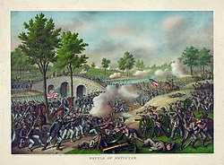
アンティータムの戦い、1862年9月17日、23,000人近い犠牲 者を出し、南北戦争のみならず、アメリカ史の中でも1日の戦闘で最も多くの犠牲者を出した戦闘となった

現在のアンティータム戦場跡
南北戦争の間にメリーランド州から出征した兵士115,000人の中で、85,000人、77%は北軍に、残りは南軍に参戦した。北軍へのメリーランドの参入を確実にするために、リンカーン大統領は人身保護令状の発行など幾つかの市民の権利を停止させた。この停止命令は後に、メリーランド生まれの最高裁判所長官ロジャー・トーニーによって違法と判断された。
州内で戦われた戦闘の中で、1862年9月17日にシャープスバーグ近くで起きたアンティータムの戦いが最大かつ最も重要なものとなった。この戦闘の結果は戦術的に引き分けであるが、戦略的には北軍の勝利であり、この戦争の転換点になったと考えられている。
メリーランド州は北軍に留まったので、反乱を起こした州にのみ適用された1863年奴隷解放宣言の執行からは除外された。メリーランド州は1864年に憲法改定会議を開き、新憲法を制定した。その第24条は奴隷制度を廃止するものだった。1867年、アメリカ合衆国憲法に解放奴隷に対する選挙権を認める修正が成立し、メリーランド州は選挙権を非白人男性まで拡大した。

ディープクリーク湖と周辺のアパラチア山脈、ガレット郡
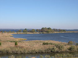
国内最大の入り江、かつ州内最大の水域であるチェサピーク湾潮汐湿地
北はペンシルベニア州、西はウェストバージニア州、東はデラウェア州に接し、大西洋に面する。南はポトマック川を隔ててウェストバージニア州とバージニア州と接する。ポトマック川の中域、メリーランド州側にはワシントンD.C.がある。その場所は元々モンゴメリー郡とプリンスジョージズ郡に属し、ジョージタウンの町を含め、1790年にコロンビア特別区を造るために連邦政府に譲渡された。同時にポトマック側の南岸、アレクサンドリア市を含むバージニア州の部分も譲渡されたが、1840年代に返還された。チェサピーク湾が州中央を二分している。湾の東にある郡部は集合的に東海岸部と呼ばれる。

パタプスコ川、有名なトマス高架鉄道橋が架かり、パタプスコバレー州 立公園に入っている。チェサピーク湾に注ぐ前にインナーハーバーを形成している
州内の水路の大半はチェサピーク湾の水域に属している。州最西端ガレット郡のほんの小さな部分はヨカゲイニー川からミシシッピ川まで流れていく。南東部ウースター郡の東半分からは大西洋岸にある湾に流れ、北西隅の小部分からはデラウェア川に流れる。地理的にも経済生活でもチェサピーク湾は州内の大きな存在なので、州の公式ニックネームを﹁湾の州﹂とする提案が何度か行われてきた。ただし、このニックネームは昔からマサチューセッツ州に使われているものである。
州内最高地点は、ガレット郡の南西隅、ウェストバージニア州との州境やポトマック川北支流の水源に近い、バックボーン山のホイ・クレストであり、標高は3,360フィート (1,020 m) である。州の西端から横幅の3分の1程度、ハンコックという小さな町の近くでは、州境に挟まれた南北の幅が1.83マイル (2.95 km) しかなく、メリーランド州は最も細い州になっている。北はペンシルベニア州とのメイソン=ディクソン線であり、南はポトマック川の北向き円弧になっている。
州内の部分は公式にも非公式にも様々な地理区分に加えられている。例えば、デルマーバ半島は、州東海岸部、デラウェア州の全体、およびバージニア州東海岸部2郡で構成されている。州西側の郡はアパラチア地方にあると見なされている。ボルチモア・ワシントン回廊の大半は海岸平原のピードモント台地南にあり[27]、その2つの領域の境目にある。
メリーランド州の地形で特徴的なのは自然湖が無いことである[28]。ただし、池は数多くある。最終氷期に氷河の先端がメリーランドまでは達していなかったので、北の州にあるような深い自然湖を造りださなかった。人工湖は多く、西端のガレット郡にある貯水池ディープクリーク湖が最大である。氷河の影響を受けなかったことで、土壌は砂や泥がおおく、北方や北東に見られる岩の多い土壌とは異なっている。

メリーランド州の郡配置図
州人口の大半はワシントンD.C.周辺の都市や郊外部、また州内最大都市ボルチモアとその周辺に集中している。昔からこれら多くの都市は、川や小川が急流となり、あるいは滝となる点を繋いだ滝線に沿って発達してきた。州都アナポリスは例外であり、チェサピーク湾近くにあって、それに注ぐセバーン川の岸にある。
その他の人口集中部としては、
●ハワード郡のコロンビアとエリコットシティの各市
●モンゴメリー郡のシルバースプリング、ロックビル、ゲイザースバーグの各市
●プリンスジョージズ郡のローレル、カレッジパーク、グリーンベルト、ハイアッツビル、ランドーバー、クリントン、ブーイ、グレーターアッパーマルボロの各市
●フレデリック郡のフレデリック市
●ワシントン郡のヘイガーズタウン市
●チャールズ郡のウォルドーフ
●ボルチモア郡のパイクスビル、エセックス、タウソンの各市
●アナランデル郡のグレンバーニー、ハノーバーの各市がある。
州東部、南部、西部には田園部が残るが、その中にも、東海岸部のソールズベリー、オーシャンシティ、南部のレキシントンパーク、ウォルドーフ、西部のカンバーランド各市などの地域にとって重要な都市が点在している。

人文地理的な区分
メリーランド州は境界州としての歴史があるので、アメリカ合衆国北部と同南部双方の性格を併せ持っている。ウェストバージニア州東パンハンドル部とペンシルベニア州に挟まれた州西部はアパラチアン文化がある。南部と東海岸部は南部の文化が強い[29]。人口の多いボルチモア市やワシントンD.C.から外側に広がる中央部はアメリカ合衆国北東部の文化が浸透している[30]。アメリカ合衆国国勢調査局[31]は大西洋岸南部に分類しているが、他の連邦機関、メディア、また住民も大西洋岸中部、あるいはアメリカ合衆国北東部に分類するのが通常である[32][33][34][35][36]。

パタクセント川カーディナル入り江湿地の夕日
その東にはピードモント台地があり、冬の降雪量は20インチ (51 cm) を超え、農務省の植物耐寒性区分では 7b と 7a に属している[37]。気温が10°F (-12 ℃) を下回るのは希である。カンバーランド・バレーから西は湿潤大陸性気候︵ケッペンの気候区分Dfa︶への移行が始まる。この地域にはボルチモア大都市圏の北部と西部、ウェストミンスター、ゲイザースバーグ、フレデリック、ヘイガーズタウンが含まれる。
さらに西はアリゲイニー郡やガレット郡の標高が高い地域であり、湿潤大陸性気候の性格が強くなる。ペンシルベニア州の南中部の気候に似ている。カンバーランド市はアルトゥーナ (ペンシルベニア州)のWTAJテレビ気象センターによる地域都市の1つに挙げられている。農務省の植物耐寒性区分では 6b とそれ以下に属している[37]。
降水量はアメリカ合衆国東海岸の特性と同様である。年間降水量は35インチ (890 mm) から45インチ (1,100 mm) であり、高度が高い地方で多い。ほとんどの地域で月間降水量は3.5インチ (89 mm) から4.5インチ (110 mm) である。年間降雪量は海岸地域の9インチ (23 cm) から西部山岳地の100インチ (250 cm) まで幅がある[38]。
大西洋岸に近いので熱帯低気圧の影響を受けやすいが、デルマーバ半島や、南のノースカロライナ州アウターバンクスが緩衝となり、カテゴリー3を超えるハリケーンに襲われることは大変希である。ただし皆無ではない。海岸に上陸または接近して勢力を落とした熱帯低気圧の名残に襲われることはある。雷雨が起こるのは年間平均30ないし40日であり、竜巻は年平均で6回発生している[39]。
17世紀[編集]

18世紀[編集]
この紛争はペンシルベニアとメリーランドの境界紛争であるクレサップの戦争︵コノジョキュラー戦争とも呼ばれる︶に繋がり、1730年代に戦われた。1730年、資産権や法の執行に関する論争から一連の暴力事件が起こったことで敵対関係が始まり、その後の5年間で加速され、1736年にはメリーランドが、1737年にはペンシルベニアが軍隊を動員した。イギリス王ジョージ2世の仲裁で1738年5月に武力衝突は終わり、休戦交渉が強制された。1732年には暫定合意にまで至った[16]。 交渉は1760年に調印された最終合意まで続いた。この合意によりメリーランドの境界は現在デラウェア州およびペンシルベニア州と共有しているものに定義された。メリーランドとペンシルベニアの境界は、フィラデルフィア市の南端から南15マイル (24 km) の線とされ、これがメイソン=ディクソン線と呼ばれるようになった。デラウェアとの境界は、デルマーバ半島の半島横断線と、ニューキャッスル市を囲む12マイル円となった[16]。
19世紀[編集]
米英戦争のとき、イギリス軍がマクヘンリー砦に守られているボルティモア港を占領しようとした。イギリス海軍が砦を砲撃したときの印象から、フランシス・スコット・キーが後に国歌となった﹃星条旗﹄を作詞した。 ボルチモア・アンド・オハイオ鉄道は国内で最初に認可された鉄道であり、1830年には最初の区間であるボルチモアとエリコットシティの間の定期運行が開始された[21]。1852年、東部海岸からオハイオ川にまで達した最初の路線となった[22]。ボルチモアの海港に鉄道が接続されたことで、19世紀の産業革命期にメリーランド州はかなりの成長を見ることになった。南北戦争後はボルチモアとその周辺に多くの製造業が設立された。 経済の変化、独立戦争以来の理想、さらにはメソジストやクエーカーの牧師の説教に影響された州内の多くの農園主が、独立戦争から20年間の内に奴隷を解放していた。これはアップランドサウスでは良く見られた現象であり、自由黒人の人口比率は独立戦争前の1%足らずから、1810年までに13.9%にまで増加していた[23]。
南北戦争[編集]
1860年までに、州内のアフリカ系アメリカ人人口に対し、49.1%が自由人となっていた[23]。このことは南北戦争の間も、メリーランド州がアメリカ合衆国︵北軍︶に留まる力になった。さらに州知事のトマス・ホリデイ・ヒックスが州議会を暫定停止にし、﹁ファイアイーター﹂と呼ばれた奴隷制度擁護派の議員を、エイブラハム・リンカーン大統領が議会の再開前に逮捕させた。リンカーンはフェデラルヒルに大砲を据えてボルチモア市を威嚇させ、新しく北軍寄りの知事と議員が選ばれるよう促した。リンカーンはボルチモア市長のジョージ・ウィリアム・ブラウンなど、特定の南部よりの著名人や州議会議員をマクヘンリー砦の監獄に収監させた。投獄された者の中にはフランシス・スコット・キーの孫も含まれていた。この戦争という危機にこれらの行動は合憲であるかについて、歴史家達は議論を続けている。ボルチモア・アンド・オハイオ鉄道のポトマック川に架かるトマス高架橋は戦略的に重要と見なされ、北軍は戦争の全期間を通じてその守備に就いた。 1861年4月、連邦軍正規兵部隊と州民兵の連隊が、ボルチモア市の﹁ベイスン﹂︵内港︶の東、フィラデルフィア・ウィルミントン・アンド・ボルチモア鉄道のプレジデント・ストリート駅に到着した。この部隊はワシントンD.C.に向かうために、ボルチモア市をボルチモア・アンド・オハイオ鉄道カムデン駅方向に行軍していたが、その途中で暴徒に襲われた。この事件は後に1861年のボルチモア暴動と呼ばれ、南北戦争では初の流血沙汰となった。この暴動で4人の兵士と12人の市民が殺された。 リンカーンは北軍守備兵にこれ以上ボルチモア市を通過させないと約束し、一方で危険に曝されている首都を守るために地域を確保させようとした。そのために首都防衛のための軍隊の大半は時間の掛かる回り道をせざるを得なくなった。マサチューセッツ州の民兵隊将軍ベンジャミン・フランクリン・バトラー︵1818年-1893年︶は、ボルチモア暴動の報せを聞いてから数日後に、セシル郡ペリービルからハーフォード郡ハバー・ド・グレイスの間のサスケハナ川を渡すフィラデルフィア・ウィルミントン・アンド・ボルチモア鉄道のフェリーボート﹁ハリエット・レーン﹂を徴発した。暴動の起きた都市を避けるためにポトマック川を下り、アナポリス市のセバーンポイントにある海軍兵学校沖で1夜を過ごし、トマス・ホリデイ・ヒックス州知事︵1798年-1865年︶の抗議にも拘わらず、マサチューセッツ州、ニューヨーク州、ロードアイランド州から連れてきた民兵隊を上陸させた。そのために、南部同調者から攻撃されないよう、海軍練習船のフリゲート艦USSコンスティチューション︵オールド・アイアンサイド︶を引っ張ってさらに沖に泊めていた。つづいて兵士の中から鉄道員やボイラーの工員を集め、操車場にあった小さな蒸気機関車を確保し、ボルチモア・アンド・オハイオ鉄道アナポリス線をエリコットシティ近くの接続点まで進ませ、そこで西はハーパーズフェリーに、南はワシントンD.Cに繋がる本線に接続できた。それから間もなく北部の部隊はアメリカ合衆国議会議事堂近くの駅に到着し、その夜はまだ建設中だった議事堂ロタンダのドーム下で、負傷者の世話をしながら宿営した。別の部隊はペンシルベニア・アベニューを進み、大統領が歓喜と安堵感で出迎えたホワイトハウスの警備を強化した。
南北戦争後[編集]
戦争中は共和党が州の政治を支配したが、戦後は民主党の白人が急速に権限を取り戻し、共和党に代わった。1864年憲法に対する支持勢力が弱まり、民主党は1867年の憲法で置き換えた。 アメリカ合衆国の北東部と中西部は産業革命の波が行き渡り、ボルチモアは拡大と繁栄を続けた。ジョンズ・ホプキンス、エノック・プラット、ジョージ・ピーボディ、ヘンリー・ウォルターズなどボルチモアの事業家達は、市内に教育、医療、文化施設を設立し、大学、図書館、音楽学校、美術館などにその名前が残った。 19世紀のメリーランド州ではカンバーランドが第2の都市だった。その付近から石炭、鉄鉱石、木材が豊富に供給された。鉄道、ナショナルロード、チェサピーク・アンド・オハイオ運河などと共にこれら資源がその成長を促した。ガラス、醸造、繊維、ブリキ板など製造業の中心だった。20世紀[編集]
19世紀末から20世紀初めの進歩主義時代、政治の分野でも労働者の労働条件でも改革が進められた。1892年から1908年までに成立した一連の法により、州が発行する投票用紙が標準となり︵それ以前は党が配り、印を付けていた︶、党の支援者が有権者の投票を﹁援助﹂しないよう閉鎖型投票ブースを採用し、党のボスが候補者を選ばないよう予備選挙を導入し、党の印が無い候補者リストを使って、文盲の者でも投票に参加できるようにした。 1902年、州は鉱山労働者の労働条件を規制した。12歳未満の児童労働者を違法とし、義務教育への出席を強制し、国内初の労働災害補償を法制化した。この法は裁判所で一旦廃案とされたが、再提出され1910年に法として成立した。 1904年2月8日のボルチモア大火は、州内最大都市と州にとって大きな出来事になった。遠くはニューヨーク市など多くの都市から駆けつけた消防士の数は1,231人を超えた。火は30時間以上燃え続け、市内70ブロックにわたり、1,526軒の建物が類焼した。 1917年、アメリカ合衆国が第一次世界大戦に参戦したことで、メリーランド州にも変化が起きた。キャンプ・ミード︵現在のフォートミード︶やアバディーン性能試験場などの新しい軍事施設が1917年に設立され、翌年にはエッジウッド武器庫が建設された。マクヘンリー砦など既存施設は拡張された。 世界恐慌の間、州内の都市部と田園部は異なる経験をした。1932年、﹁ボーナス軍隊﹂が州内を通ってワシントンD.C.まで行進した。フランクリン・ルーズベルト大統領が採った全国的なニューディール政策では、多くの者を道路や公園の建設に使ったが、これに加えて、メリーランド州も苦難の時を乗り越える手段を採った。例えば1937年には学校や福祉のために使う目的で所得税を導入した。 第二次世界大戦のとき、ボルチモアは軍需品の主要生産地となった。その最大のものは、リバティ船を建造したベスレヘム・スチールのフェイフィールド造船所や、航空機製造のグレン・マーティンだった。 戦後のメリーランド州は郊外部、特にボルチモアとワシントンD.C.を取り囲む地域が成長した。コロンビアやモンゴメリービレッジでは農地が住宅地に転換された。同時に州間高速道路体系が建設され、特に95号線や495号線が交通の態様をはっきりと変えた。1952年、州の東半分と西半分が長大なチェサピーク湾橋で初めて結ばれ、フェリーの役目に代わった[24]。この橋がオーシャンシティへの観光客を増やし、建設ブームになった。その後間もなくボルチモア港トンネルで、長距離を移動するものにとってボルチモア中心街をバイパスできるようになり、ハリー・W・ナイス記念橋はワシントンD.C.をバイパスできるようにさせた。 国内の都市と同じように、戦後のボルチモアでは重工業が衰退した。下流部の東部海岸では大規模な機械化された養鶏場が主流になり、灌漑を施された野菜農場もできた。州南部では20世紀の終わりまでにタバコ農園がほとんど姿を消した。これは郊外の住宅開発がすすんだことと、州がタバコの買い取りを進めたためだった。西部4郡の工業、鉄道、石炭鉱業は衰退した。 ボルチモア市は1960年代から都市再開発を進め、チャールズセンターやボルチモア世界貿易センターが造られた。1980年、バーバープレースやボルチモア水族館ができて重要な観光地になった。野球場のカムデン・ヤーズが1992年に中心街にオープンした。地理[編集]
自然地理[編集]
メリーランド州の面積は12,406.68平方マイル (32,133.2 km2) あり、ヨーロッパの国ではベルギーの大きさ︵11,787平方マイル、30,530km2︶に匹敵する[25]。国内50州の中では第42位であり、第43位のハワイ州︵11,787平方マイル、28,311.1km2︶と接近している。第41位は西隣のウェストバージニア州︵24229.76平方マイル、62,754.8km2︶であり、ほぼ2倍である。 州内には多様な地形があり、﹁アメリカのミニチュア﹂というニックネームもある[26]。東部の海草が点在する砂丘地帯から、チェサピーク湾に近い野生生物とヌマスギが群がる低湿地、ピードモント台地のオーク林がある穏やかにうねる丘陵部、西部山岳地の松林まで様々である。


人文地理[編集]
参照‥メリーランド州の郡一覧

気候[編集]
メリーランド州は標高の違い、水域との接近度、また山を下る風︵滑降風︶から守られている程度の違いによって様々な気候を呈している。 州の東半分は大西洋岸平原にあり、大変平坦な地形と砂や泥の多い土壌である。この地域は温暖湿潤気候︵ケッペンの気候区分Cfa︶にあり、暑く湿気た夏と、短く温暖から冷涼な冬が特徴である。アメリカ合衆国農務省の植物耐寒性区分では 8a に属している[37]。この地域にある都市としては、ソールズベリー、アナポリス、オーシャンシティ、およびワシントンD.C.とボルチモアの南部と東部の郊外がある。
| 州内各都市の月別平均最高最低気温 | ||||||||||||
| 都市 | 1月 | 2月 | 3月 | 4月 | 5月 | 6月 | 7月 | 8月 | 9月 | 10月 | 11月 | 12月 |
|---|---|---|---|---|---|---|---|---|---|---|---|---|
| フロストバーグ | 34 °F (1 ℃) 18 °F (-8 ℃) |
37 °F (3 ℃) 20 °F (-7 ℃) |
46 °F (8 ℃) 26 °F (-3 ℃) |
58 °F (14 ℃) 37 °F (3 ℃) |
67 °F (19 ℃) 46 °F (8 ℃) |
75 °F (24 ℃) 55 °F (13 ℃) |
79 °F (26 ℃) 59 °F (15 ℃) |
78 °F (26 ℃) 58 °F (14 ℃) |
71 °F (22 ℃) 51 °F (11 ℃) |
60 °F (16 ℃) 41 °F (5 ℃) |
49 °F (9 ℃) 32 °F (0 ℃) |
37 °F (3 ℃) 23 °F (-5 ℃) |
| カンバーランド | 41 °F (5 ℃) 22 °F (-6 ℃) |
46 °F (8 ℃) 24 °F (-4 ℃) |
56 °F (13 ℃) 32 °F (0 ℃) |
68 °F (20 ℃) 41 °F (5 ℃) |
77 °F (25 ℃) 51 °F (11 ℃) |
85 °F (29 ℃) 60 °F (16 ℃) |
89 °F (32 ℃) 65 °F (18 ℃) |
87 °F (31 ℃) 63 °F (17 ℃) |
80 °F (27 ℃) 55 °F (13 ℃) |
69 °F (21 ℃) 43 °F (6 ℃) |
57 °F (14 ℃) 34 °F (1 ℃) |
45 °F (7 ℃) 26 °F (-3 ℃) |
| フレデリック | 42 °F (6 ℃) 26 °F (-3 ℃) |
47 °F (8 ℃) 28 °F (-2 ℃) |
56 °F (13 ℃) 35 °F (2 ℃) |
68 °F (20 ℃) 45 °F (7 ℃) |
77 °F (25 ℃) 54 °F (12 ℃) |
85 °F (29 ℃) 63 °F (17 ℃) |
89 °F (32 ℃) 68 °F (20 ℃) |
87 °F (31 ℃) 66 °F (19 ℃) |
80 °F (27 ℃) 59 °F (15 ℃) |
68 °F (20 ℃) 47 °F (8 ℃) |
56 °F (13 ℃) 38 °F (3 ℃) |
45 °F (7 ℃) 30 °F (-1 ℃) |
| ボルチモア | 42 °F (6 ℃) 29 °F (-2 ℃) |
46 °F (8 ℃) 31 °F (-1 ℃) |
54 °F (12 ℃) 39 °F (4 ℃) |
65 °F (18 ℃) 48 °F (9 ℃) |
75 °F (24 ℃) 57 °F (14 ℃) |
85 °F (29 ℃) 67 °F (19 ℃) |
89 °F (32 ℃) 72 °F (22 ℃) |
87 °F (31 ℃) 71 °F (22 ℃) |
80 °F (27 ℃) 64 °F (18 ℃) |
68 °F (20 ℃) 52 °F (11 ℃) |
58 °F (14 ℃) 43 °F (4 ℃) |
46 °F (9 ℃) 33 °F (0 ℃) |
| オーシャンシティ | 45 °F (7 ℃) 28 °F (-2 ℃) |
46 °F (8 ℃) 29 °F (-2 ℃) |
53 °F (12 ℃) 35 °F (2 ℃) |
61 °F (16 ℃) 44 °F (7 ℃) |
70 °F (21 ℃) 53 °F (12 ℃) |
79 °F (26 ℃) 63 °F (17 ℃) |
84 °F (29 ℃) 68 °F (20 ℃) |
82 °F (28 ℃) 67 °F (19 ℃) |
77 °F (25 ℃) 60 °F (16 ℃) |
68 °F (20 ℃) 51 °F (11 ℃) |
58 °F (14 ℃) 39 °F (4 ℃) |
49 °F (9 ℃) 32 °F (0 ℃) |
| [40][41][42][43][44] | ||||||||||||
植物相[編集]
メリーランド州は東海岸にある州と同様に植物が豊富で繁殖している。年間雨量が適度にあることで小さなものは海草や各種ヨシから、大きなものはホワイトオークが巨大になったワイオークまで多種の植物を茂らせている。ワイオークは高さ70フィート (21 m) を超えることもある。
大西洋岸中部海岸林は大西洋岸平原南東部に典型的なものであり、チェサピーク湾沿岸やデルマーバ半島に育っている。それより西では、北東海岸林と南東混合林が混合し、州中央部を覆っている。さらに西のアパラチア山脈にはアパラチアン・ブルーリッジ林がある。ウェストバージニア州との州境近くではアパラチアン中性混合林に変わっていく[45]。
州内で多くの外来植物が栽培されており、観賞用や贈答用もある。暖かい地域ではサルスベリ、イタリアイトスギ、ライブオーク︵カシ︶があり[46]、さらに暖かい中部や東部では椰子の木も見られる[47]。農務省の植物耐寒性区分では、州西端で5と6、中央部で7、南部海岸、湾岸、ボルチモア大都市圏の一部で8となっている[37]。クズ、ニワウルシ、ノイバラ、アシボソなど外来種が固有種の成長を抑えている[48]。州花であるブラック・アイド・スーザンは州内どこでも野草の中に豊富に見られる。州の昆虫であるボルチモアヒョウモンモドキ︵蝶︶はその南限に近いのであまり見られない[49]。州内では435種の鳥が観測されている[50]。

野生のチンコティーグ・ポニー、アサティーグ島
州内には多数のシカがおり、特に州西部の森林や山岳部で多く、年々過繁殖が問題になってきている。哺乳類は西部の山岳地から中央部まで見られ、クマ[51]、ボブキャット[52]、キツネ、コヨーテ[53]、アライグマ、カワウソがいる[51]。
アサティーグ島では個体数が減った野生馬がいる[51][54]。毎年7月の最終週に、野生馬が捕獲され、浅い湾を渡して、バージニア州チンコティーグで売却されている。この保存手段によりこの小さな島が馬で溢れないようにされている。このポニーとその販売については子供向けの図書﹃チンコティーグのミスティ﹄に紹介された。難船から逃げ出した馬の子孫と考えられている。
純血種のチェサピーク・ベイ・レトリーバーは、ウォータースポーツ、狩猟、捜索、救助用に飼われている[55]。1878年、アメリカンケネルクラブが認定した最初のレトリーバー種となった[55]。
爬虫類と両生類ではダイヤモンドガメ︵キスイガメ︶が特筆され、メリーランド大学カレッジパーク校のマスコットになっている。ボルチモアムクドリモドキの生息域であり、州の公式鳥に指定され、メジャーリーグベースボールのボルチモア・オリオールズはチーム名とマスコットに使っている[56]。
動物相[編集]

環境意識[編集]
2007年、Forbes.com は国内で﹁緑豊かな﹂州の第5位にメリーランド州を指定した。上位には太平洋岸3州とバーモント州が来ていた。エネルギー消費量では国内第40位であり、2005年では1人当たり有害廃棄物量で国内第7位だった[57]。2007年4月、温室効果ガス排出を減らすための、北東部の州全てとワシントンD.C.およびカナダの3州で構成する地域温室効果ガス・イニシアティブのメンバーになった。地震[編集]
メリーランド州は構造プレートや地震帯から遠いために、地震は希である。起こったとしても小さいが、有感の地震はあった[58][59]。2011年に起きたマグニチュード5のバージニア地震は州全体で幾らか感じられた。州内のビルは耐震設計が施されておらず、簡単に壊れる可能性もある。国立公園[編集]
国立公園局の管理及び保護下にある地域は以下の通りである。- アンティータム国立戦場跡(シャープスバーグ近郊)
- アンティータム国立墓地
- アパラチア国立景観側道
- アサティーグ島国立海岸
- ボルチモア・ワシントン・パークウェイ
- カトクチン山公園(サーモント)
- チェサピーク・アンド・オハイオ運河国立歴史公園(ポトマック川)
- チェサピーク湾ゲイトウェイズ・ネットワーク
- クララ・バートン国立歴史史跡(グレンエコー)
- フォートフット公園(オクソンヒル)
- マクヘンリー砦国立記念碑と歴史堂(ボルティモア)
- フォートワシントン公園(フォートワシントン)
- ジョージ・ワシントン記念パークウェイ
- グレンエコー公園(グレンエコー)
- グリーンベルト公園(グリーンベルト)
- ハンプトン国立歴史史跡(タウソン)
- ハーモニーホール(プリンスジョージ郡)
- モノカシー国立戦場跡(フレデリック近郊)
- オクソンコーブ公園とオクソンヒル農園(オクソンヒル)
- ピスカタウェイ公園(アッコキーク)
- ポトマック文化遺産国立景観側道(チェサピーク湾及びアリゲイニー高原間の回廊)
- スウィートランド・パークウェイ(プリンスジョージ郡)
- トマス・ストーン国立歴史史跡(ポートトバコ)
人口動態[編集]
| 人口推移 | |||
|---|---|---|---|
| 年 | 人口 | %± | |
| 1790 | 319,728 | — | |
| 1800 | 341,548 | 6.8% | |
| 1810 | 380,546 | 11.4% | |
| 1820 | 407,350 | 7.0% | |
| 1830 | 447,040 | 9.7% | |
| 1840 | 470,019 | 5.1% | |
| 1850 | 583,034 | 24.0% | |
| 1860 | 687,049 | 17.8% | |
| 1870 | 780,894 | 13.7% | |
| 1880 | 934,943 | 19.7% | |
| 1890 | 1,042,390 | 11.5% | |
| 1900 | 1,188,044 | 14.0% | |
| 1910 | 1,295,346 | 9.0% | |
| 1920 | 1,449,661 | 11.9% | |
| 1930 | 1,631,526 | 12.5% | |
| 1940 | 1,821,244 | 11.6% | |
| 1950 | 2,343,001 | 28.6% | |
| 1960 | 3,100,689 | 32.3% | |
| 1970 | 3,922,399 | 26.5% | |
| 1980 | 4,216,975 | 7.5% | |
| 1990 | 4,781,468 | 13.4% | |
| 2000 | 5,296,486 | 10.8% | |
| 2010 | 5,773,552 | 9.0% | |
| 2020 | 6,177,224 | 7.0% | |
| Source: 1910–2010[60] | |||

2020年国勢調査時点で、メリーランド州の人口は6,177,224人で、2010年国勢調査時点からは6.99%増加した[61]。
2006年時点、外国生まれは645,744人であり、主にラテンアメリカ及びアジアから来ていた。このうち約4.0%はビザを持たない不法在留外国人である。韓国系アメリカ人の人口が多い[62]。アジア系アメリカ人がほぼ6.0%いるのに対し、韓国系アメリカ人は1.7%である[63]。
メリーランド州の人口の多くはボルチモア・ワシントン大都市圏内の、ボルチモア都市圏とワシントン都市圏に住んでいる。東海岸部は人口が少ない田園部であり、西部や南部も同様である。
西部のアリゲイニー郡とガレット郡は山が多く、人口が少ない。メリーランド州よりもウェストバージニア州に類似している。アフリカ系アメリカ人の割合は18世紀のタバコ栽培場生産高がピーク︵38%︶に達したころほど高くないが、メリーランド州には今でも深南部以外の州では最大の黒人人口を有している。
メリーランド州の人口重心は、アナランデル郡及びハワード郡の郡境にあるジェサップという未編入の町にある[64]。
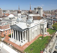
ボルティモア・バシリカ、国内初のローマ・カトリック大聖堂、建築家 ベンジャミン・ヘンリー・ラトローブの傑作と見なされている
メリーランド州はイングランドで少数派だったローマ・カトリック教徒にとって、宗教的寛容さを与えるために設立された。しかしイギリスの議会はその政策を覆し、メリーランドでカトリック信仰を排除した。移民の構成によってメリーランド州は植民地時代からカトリック教徒が多数にはならなかった。それでもカトリックは単一宗派として最大である。
2000年時点で、RCMSに拠れば、カトリック教徒が952,389人で第1位、信徒数の第2位はメインライン・プロテスタント、第3位は福音主義プロテスタントである。ユダヤ教は信徒数241,000人、人口構成比4.3%であり、非キリスト教としては最大である[73]。
人種及び祖先[編集]
2011年推計に拠れば、メリーランド州の人種による人口構成は次のようになっている[65]。 ●61.1% 白人︵非ヒスパニック白人は54.4%、ヒスパニック白人は6.7%︶ ●30.0% 黒人 ●5.8% アジア ●0.5% インディアン ●0.1% 太平洋諸島系 ●2.5% 混血 ●8.4% ヒスパニック[66] メリーランド州で申告された祖先祖先による構成比は、ドイツ系 (15.7%)、アイルランド系 (11.7%)、イギリス系 (9%)、アメリカ人 (5.8%)、イタリア系 (5.1%)[67]だった。 1970年の国勢調査では、アフリカ系アメリカ人人口構成比を17.8%、非ヒスパニック白人80.4%と報告していた[68]。アフリカ系アメリカ人は2010年で30%となっており[66]、これにはナイジェリアのイグボ族移民が含まれている[69]。アフリカ系アメリカ人は州全体に多く住んでいるが、特にボルチモア市、プリンスジョージズ郡、チャールズ郡、ランドールズタウン、東海岸部南部に多い。 2011年時点で1歳未満の幼児の58.0%は少数民族の両親に生まれていた[70]。 東海岸部と南部はイギリス人を祖先とする者が多く、東海岸部は伝統的にメソジスト、南部はカトリック教徒が多い。西部と北部はドイツ系アメリカ人が多い。イタリア系、ポーランド系、チェコ系、ギリシャ系は主に大都市のボルチモアに集中している。ヒスパニック系はハイアッツビル、ラングレーパーク、ウィートン、ブラーデンスバーグ、リバーデール、ゲイサーズバーグ、東ボルチモアのハイランドタウンに多い。エルサルバドル系がヒスパニックの中では最大である。他にそこそこの人口があるものとして、メキシコ系とプエルトリコ系がある。エルサルバドル系がワシントンD.C.を中心とした地域に多いのに対し、プエルトリコ系はボルチモア地域に集中し、他のヒスパニック系もこの2つの大都市圏の間に分散している。ヒスパニック系の多様さについては国内でも最大級であり、カリブ海や中央アメリカの国々からかなりの人々が移住してきている[71]。 ユダヤ系はモンゴメリー郡とボルチモア北西のパイクスビル、およびオーウィングスミルズに多い。アジア系アメリカ人はワシントンD.C.を取り巻く郊外郡に集中し、特に韓国系と台湾系はロックビルに、フィリピン系はフォートワシントンにコミュニティがある。インド系も特に中央部に多い。セントメアリーズ郡、ガレット郡、ワシントン郡ではアーミッシュやメノナイトの集落も見られる。 少数民族比率の多さでは国内第5位である[72]。宗教[編集]

|
宗派別構成比 | |||||
|---|---|---|---|---|---|
|
キリスト教 |
非キリスト教 | ||||
| ローマ・カトリック教会 | 24% | ユダヤ教 | 4% | ||
| バプテスト | 18% | 他のキリスト教 | 3% | イスラム教 | 1% |
| メソジスト | 11% | 他の宗教 | 1% | ||
| ルーテル教会 | 6% | 無宗教 | 11% | ||
| その他のプロテスタント | 21% | ||||
プロテスタントが多数派であるが、国内ではカトリックの伝統が強い州である。これには植民地領主のジョージ・カルバートがイングランド・カトリック教徒の安息地とすることを目指したことが係わっている。ボルチモアは国内初のカトリック司教が就いたところであり︵1789年︶、エミッツバーグはアメリカ初の聖人セントエリザベス・アン・シートンが生まれ、埋葬された場所である。最初のカトリック系大学ジョージタウン大学は1789年に州内に設立された︵現在はワシントンD.C.︶[注 2]。ボルチモアにある聖母マリア被昇天バシリカは国内初のローマ・カトリック大聖堂であり、ボルチモア大司教は正式な位階ではないが、擬似的な職位であり、枢機卿と呼ばれることも多い。
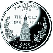
メリーランド州4分の1ドル硬貨裏面、アナポリスの州会議事堂ドーム が描かれている
メリーランド州政府はメリーランド州憲法に従って運営されている。他の49州と同様、アメリカ合衆国憲法に規定されることを除き、州内の事情について排他的権限を持っている。
三権が分立されている。行政府、立法府、司法府である。州議会は下院と上院の両院制である。州知事は他の州とは異なり予算についてかなりの権限が与えられている。議会は知事が提案する予算支出を増やすことが許されていない。他州とは異なり多くの郡にかなりの自治権が認められている。
政府の事業の大半は州都アナポリスで遂行されている。事実上州と郡の全選挙は4で割り切れない偶数年に行われている。このことでアメリカ合衆国大統領選挙とは別の年に選挙が行われ、州と連邦の政治を分けることが意図されている。
司法府は各郡とボルチモア市にある州統合地区裁判所と、各郡とボルチモア市にある24の巡回裁判所があり、巡回裁判所は訴訟額3万ドル以上の民事事件全て、衡平法上の訴訟全て、重要な刑事事件を扱う一般的裁判所である。中間控訴裁判所は特別控訴裁判所と呼ばれ、州最高裁判所は控訴裁判所と呼ばれる。控訴裁判所の判事は赤いローブを纏うことで、国内でも唯一の存在である[74]。

スピロ・アグニュー、元アメリカ合衆国副大統領、建国以来メリーラン ド州出身の政治家としては最高位に就いた指導者
最近15回のアメリカ合衆国大統領選挙では一貫して民主党候補を支持してきており、平均支持率差は15.4%だった。1980年にはジミー・カーターを選んだ6州の1つだった。近年は民主党候補にとって最も頼れる州になっている。1992年、ビル・クリントンは出身州であるアーカンソー州以外ではどの州よりもメリーランド州での支持率が高かった。1996年ではクリントン支持率で第6位であり、2000年のアル・ゴア支持率で第4位、2004年のジョン・ケリー支持率で第5位だった。2008年は州内でバラク・オバマが61.9%の支持を得て10人の選挙人票を得た。対するジョン・マケインは36.5%に留まった。
共和党は西部と東部の郡では大差で勝利しているが、人口の多い地域、民主党主軸のボルチモア・ワシントンではほとんど勝てない。例えば2008年、ジョン・マケインは17郡を制し、対するオバマは6郡を制しただけだった。オバマはボルチモア市も制した。マケインは西部と東部の郡で2対1以上の得票差で制したが、ボルチモア市とワシントンD.C周辺の郡では全く勝てなかった。大型郡のうちアナランデル郡以外は全てオバマが制した[75]。
メリーランド州選出のアメリカ合衆国上院議員2人と下院議員8人のうち7人は民主党員であり、州議会では民主党が絶対多数を占めている。前知事ロバート・アーリックは40年ぶりの共和党知事となり、1期を務めただけで民主党員のボルチモア市長マーティン・J・オマリーにその座を明け渡した。アーリックは2010年にも再出馬したが、オマリーに再度敗れた。
アメリカ合衆国下院議員スティニー・ホイヤー︵第5選挙区、民主党︶は第110議会の多数派院内総務に選ばれて2007年から2011年まで務めた。その選挙区にはアナランデル郡とプリンスジョージズ郡の一部、州南部のチャールズ郡、カルバート郡、セントメアリーズ郡の全部が含まれている[76]。
メリーランド州は民主党の強固な地盤だが、最も著名な政治家は共和党のスピロ・アグニュー元知事であり、リチャード・ニクソン政権ではアメリカ合衆国副大統領を務めた︵在任1969年-1973年︶。アグニューはメリーランド州知事時代に賄賂を受け取っていたことが暴露され、副大統領を辞任した。1973年後半、アグニューは税法違反で有罪となった。
2010年の選挙では、共和党が多くの郡を制し、民主党はボルチモア市を含む8郡の支配に留まった。

ボルチモア港
アメリカ合衆国商務省経済分析局は2006年のメリーランド州の州総生産高が2,570億米ドルであると推計した[78]。しかし、メリーランド州はGDPのような成長指数だけでなく、州の発展を導くために福祉の指数である純粋進展指数を用いてきた[79][80]。国勢調査局統計では、2009年の世帯当たり収入中央値が69,272ドルとなり、全米一の裕福な州である[81]︵第2位はニュージャージー州、第3位はコネチカット州だった︶。郡の単位ではハワード郡が第3位、モンゴメリー郡が第10位だった。また貧困線以下の人口比率は7.8%であり、全米最小である[82][83][84]。2006年の一人当たりの収入は合衆国内で5番目に位置する、43,500米ドルだった。
2012年3月時点で、失業率は6.6%だった[85]。
メリーランド州の経済活動は第三次サービス産業に強く集中しており、その地理的な位置づけに強く影響されている。サービス産業の1つが輸送業であり、ボルチモア港を中心に鉄道と徒タックが組み合わされている。港の2008年の取扱貨物量は国内第17位だった[86]。取り扱う製品は多様であるが、最も多い輸入品は、鉄鉱石、石油、砂糖、肥料など原材料やばら積み資材であり、陸の輸送機関を介して内陸中西部の比較的近い工業地帯に配送されるものが多い。幾つかのブランドの自動車も輸入しており、その数では国内第2位である。
サービス産業の2つめはワシントンD.Cの連邦政府に近いという位置づけを生かしたものであり、防衛・航空産業やバイオ研究所などの技術や管理の業務があり、またボルチモア、ワシントンD.C地域の郊外部あるいは準郊外部にある政府の支所の職員がいる。さらに多くの教育や医療の研究機関がある。ジョンズ・ホプキンス大学とその医療研究施設の様々な部門が、ボルチモア地域では最大の雇用主である。またホワイトカラーの技術、管理職が州内労働力の25%を占めており、連邦政府職員の比率が高いワシントン大都市圏に属していることが寄与している。
食品加工業も大きい。チェサピーク湾を中心とする商業漁業が大きな要素であるが、大西洋沿岸漁業も含まれている。漁獲対象はワタリガニ、カキ、シマスズキ、メンハーデンなどである。チェサピーク湾の野生生物保護区では越冬する水鳥も多い。これが観光の対象になっている。

農業は州経済の重要部分である
州内海岸部とピードモント台地には広い肥沃な農地があるが、都市化によって徐々に侵食されてきている。山岳部の麓やピードモント台地では酪農が盛んであり、近くの大都市に乳製品を送る他、キュウリ、スイカ、スイートコーン、トマト、マスクメロン、カボチャ、豆類など生鮮野菜を栽培している。さらにチェサピーク湾西岸の南部郡は暖かいので、タバコが植民地時代以来の換金作物だったが、1990年代に州政府が買い上げるようになって大きく衰退してきた。南東部には機械化された大型養鶏場もある。ソールズベリーにはパーデュー農園がある。州内の食品加工工場は産出額で州内でも最も重要な製造業である。
製造業は売り上げが大きいがかなり多様化しているために、その1部門で全体の20%を超えるようなものは無い。点綴的な製造部門は電子工業、コンピュータ機器、化学品である。かつては主要金属が主力であり、スパロウズポイントには世界最大の製鉄所があった時もあった。この製鉄所は現在もあるが、海外との競争に押されて破産し、会社は併合された。第二次世界大戦中、グレンマーティン社︵現在のロッキード・マーティン︶の航空機工場は4万人ほどを雇用していた。
建材以外の鉱業は事実上石炭に限られ、鉱山は州西部の山岳地にある。東部の褐色砂岩採石場は、ボルチモアやワシントンで19世紀半ばの建築に強く影響を与え、かつては最大の自然資源だった。州内には小さな金鉱山があったこともあり、しかもワシントンの近くだったが、現在は残っていない。
ボルチモア市は国内第8位の港であり、2006年にドバイ・ポーツ・ワールド社の取引に関する論争では、戦略的に重要な位置づけにあったので、その中心になった。州全体の工業化が進んでおり、経済の好況と影響力のある技術の中心である。コンピュータ産業は国内でも進化しており、連邦政府はこの地域に大きな投資をしてきた。また州内には幾つかの大きな軍事基地があり、政府関連の仕事も多い。
州内の主要都市と道路
州内を通る州間高速道路は、延長180キロメートルの州間高速道路95号線があり、州北東部から入り、ボルチモア市を通り、州間高速道路495号線の東部に合流してウッドロウ・ウィルソン記念橋に向かう。68号線は州西部とハンコックという小さな町で70号線を繋ぐ、延長130キロメートルである。70号線はハンコックの北、ペンシルベニア州から入り、ボルチモア市まで150キロメートル走り、道中でヘイガーズタウンやフレデリックを繋ぐ。
83号線は延長55キロメートルでボルチモア市とペンシルベニア州南中部︵ハリスバーグ (ペンシルベニア州)ハリスバーグやヨーク︶を繋ぐ。州間高速道路81号線も18キロメートルが州内を通り、ヘイガーズタウン近くを抜ける。97号線はアナランデル郡に全体が入る、1桁あるいは2桁の州間高速どうろとして2番目に短いものであり、ボルチモア地域とアナポリス地域を繋いでいる︵ハワイ州に最短の道路がある︶。
補助的な州間高速道路も幾つかある。その中の2本は主要都市を環状に回るものである。695号線、マッケルディン・ベルトウェイはボルチモアを取り巻いている。495号線、キャピタル・ベルトウェイはワシントンD.C.を取り巻いている。270号線はフレデリック地域と北バージニア、コロンビア特別区、ワシントンD.C.の北西郊外部を繋いでおり、主要な通勤道路であり、場所によっては14車線ある。
270号線と495号線はどちらも渋滞が激しい。しかし、インターカウンティ・コネクター、略号ICCが渋滞を幾らか緩和できると期待されている。ICCの建設は前知事ロバート・アーリックの選挙公約で主要部だった。アーリックは州知事を2003年から2007年まで務め、後継者のマーティン・オマリーも同じ公約を掲げている。595号線はアメリカ国道50号線および同301号線と合流し、国内でも表示のない州間高速道路として最長であり、プリンスジョージズ郡とワシントンD.C.、アナポリスを繋ぎ、チェサピーク湾橋を介して東海岸部に渡る。

チェサピーク湾橋、東海岸部と西海岸部を繋ぐ、リゾート地のオーシャ ンシティに行く観光ルート
州内には2号線から999号線までつけられた州道の体系もある。ただし番号の大きな州道は表示が無いか、比較的短距離である。主な州道としては、2号線、4号線、5号線、32号線、45号線、97号線、100号線、210号線、235号線、295号線、355号線、404号線、650号線がある。
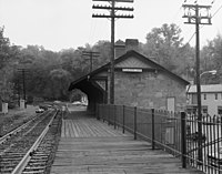
エリコットシティ駅、ボルチモア・アンド・オハイオ鉄道では最古の現 存する乗客駅、この路線はCSXトランスポーテーションが使用しており、駅は博物館になっている

州内最大の大学であるメリーランド大学カレッジパーク校の記念礼拝堂
公立の初等中等教育はメリーランド州教育省が監督しており、ボルチモア市に本部がある[96]。州教育部門の長は州教育監督官であり、教育委員会が指名し、任期は4年間である。州議会は監督官と教育委員会に対して、教育関連の判断については裁量権を与えており、公共教育の日々の機能には干渉を制限している。各郡とボルチモア市には地方教育委員会があり、公立学校の運営と特別な管理を行わせている。
州の教育予算は2009年で55億ドルであり、州の一般会計予算の約40%に相当している[97]。
州内には幅広い私立の初等中等教育学校がある。これらの多くは、カトリックの教区学校、クエーカー、セブンスデー・アドベンチスト教会、ユダヤ教など様々な宗派に属している。2003年メリーランド州法が変更され、公的資金によるチャータースクール創設が認められた。ただしチャータースクールは地方の教育委員会に承認されねばならず、団体交渉法など教育に関する州法の適用を除外されない。
2008年、州は飛び級試験に合格する生徒の比率について全郡を指導した。2008年5月の試験では23.4%の生徒が合格した。これはメリーランド州がその栄誉を得た最初の年になった[98]。この成績で州内の3つの高校が国内100傑に入った[99]。
インディアン部族[編集]
もともとこの州には、コノイ族︵ピスカタウェイ族︶、デラウェア族、ナンチコーク族、チョプタンク族、ポコモケ族、ポウハタン族、ショーニー族、サスケハンナ族などが先住し、ウィグワムの集落を形成し、農耕生活を営んでいた。最初期からイギリス人入植者の侵略を受け、幾多の領土を巡る戦いによって弱体化した。 同州のインディアン部族は黒人奴隷を部族員として迎え入れ、混血︵ブラック・インディアン︶が増加した。これを受けて州政府は﹁一滴規定︵下項参照︶﹂を基に、これらをインディアンと認めず、19世紀末にインディアン保留地の保留を解消し、同州の部族をすべて解体して﹁絶滅﹂扱いとした。 ピスカタウェイ族の呪い師ターキー・タヤク︵1895年〜1978年︶は、連邦・州の扱いに対し、徹底抗議運動を続けた運動家だった。彼は部族の墳墓遺跡モヤオネの開発を阻止するため、﹁ピスカタウェイ国立公園﹂の創設を内務省に働きかけ、また、その見返りとしてピスカタウェイ族の同地への自由往来と、自分が死んだらこの墳墓へ埋葬するよう、約束をとりつけた。 ターキー酋長は、﹁アメリカインディアン運動︵AIM︶﹂と共闘し、ラムビー族、ポウハタン族、ナンチコーク族など周辺部族の権利回復運動をまとめ、また1974年に﹁ピスカタウェイ・コノイ族法人組織﹂を結成した。1978年に白血病で死の床に伏したターキーは、﹁モヤオネ墳墓遺跡に埋葬してくれ﹂との内務省BIAとの約束を遺言に残した。しかし、彼の遺体を墳墓に埋葬するためのグラディス・スペルマンの議案は合衆国議会で否決され、ポール・サーベーンズ上院議員や﹁全米インディアン国民会議﹂の支援で、ターキー酋長の埋葬が実現したのはようやく一年後になってからだった。彼の埋葬場所には目印に赤杉が植えられた。 ターキー酋長の運動は受け継がれ、1990年代後半には、メリーランド州に任命された系譜学者たちによる調査委員会によって、ピスカタウェイ族の共同体からの異議申し立てが認められ、2007年8月29日にはクリストファー・グッドウィン博士らによって、インディアンとしての血統を有効とする証言書が提出された。これがピスカタウェイ族の連邦公認要求に有利なものになるかどうかはわからない。 同州ランドーバーに本拠地を持つプロスポーツチームの﹁ワシントン・レッドスキンズ﹂は、インディアン戦士の肖像をチームマークとし、﹁赤い肌﹂というインディアンに対する差別語をチーム名としている。全米のインディアン団体はこの名称の撤廃を求め、数10年来の激しい抗議をNCAA並びに同チームに寄せていた。2022年、同チームは﹁ワシントン・コマンダース﹂に名称変更した。 現在、この州にアメリカ連邦政府が認定しているインディアン部族はない。彼らは保留地︵Reservation︶を持てず、部族単位では存在しないことになっている。 ≪アメリカ連邦政府に公式認定を要求中のインディアン部族≫ ●﹁ピスカタウェイ族﹂ ●﹁ピスカタウェイ・コノイ族連邦﹂ ●﹁アッコハンノック族﹂ ●﹁ショーニー族・ユーギオガヘニー川バンド﹂インディアンと﹁一滴規定﹂[編集]
19世紀も末になると、連邦とメリーランド州政府は黒人と混血した同州のインディアンたちを、アメリカ合衆国に住んでいる人間を﹁一滴でも黒人の血が入ったらもう黒人である﹂と規定する﹁一滴規定﹂︵ワンドロップ・ルール︶に基づき、人種的に﹁インディアン﹂から﹁ニグロ﹂、または﹁ムラート﹂、あるいは﹁ブラック﹂になったとした。彼らは﹁ジム・クロウ法﹂の対象となり、﹁自由身分の色つき︵free people of color︶﹂、または﹁自由身分の黒人︵Free negro︶﹂という扱いで出生証明書に記載された。﹁インディアンではなくなった﹂ことになったメリーランド州の﹁元・インディアン﹂はインディアン条約をすべて破棄され、20世紀までにはすべて、保留地領有をはじめとするインディアンの権利を剥奪された。インディアン・カジノ[編集]
同州ではインディアン部族は存在しないことになっており、現在のところインディアン部族が運営する﹁インディアン・カジノ﹂は一軒もない。州のスロットマシン導入方針で、他州の連邦認定インディアン部族による﹁インディアン・カジノ﹂が設立される可能性はある。主要な都市及び町[編集]
主要記事‥List of cities in Maryland 関連項目‥List of census-designated places in Maryland 及び Maryland locations by per capita income ●アナポリス市 – 州都、海軍兵学校の本部。チェサピーク湾にかかるベイブリッジでも有名。 ●ボルティモア市 – 最も人口の多い都市︵2020年国勢調査時点で585,708人[61]︶。いずれの郡にも属さない独立市︵郊外部となるボルティモア郡に囲まれている︶。商業と文化の中心。 ●ベセスダ – ワシントンDCの政府機関に勤務するエリート官僚たちが多く住む高級住宅地。世界最大の研究所といわれるアメリカ国立衛生研究所を抱える。 ●ゲイザースバーグ市 – NISTの本部がある。 ●カレッジパーク市 – D.C. の郊外、メリーランド大学の本部。米国立公文書館の別館や、政府とライト兄弟らが用いた、飛行機の試験場︵現在も飛行場、博物館併設︶がある。 ●コロンビア – 行政に編入されておらずコロンビア協会 (en:Columbia Association) が運営する大きな国勢調査指定地域 ●フレデリック – アパラチア山脈への西部入口、郊外の中心地 ●ヘイガーズタウン – 州西部の3郡内で最大の町。 ●ローレル市 – 州間高速道路95号線上のボルティモア及びワシントン間の最大郊外コミュニティ。(en:Laurel, Maryland) ●オーシャンシティ – 大西洋海岸沿いの大変人気なビーチリゾート。(en:Ocean City, Maryland) ●ロックビル市 – ワシントンの北西部、富裕なモンゴメリー郡のビジネス中心地 ●ソールズベリー – デルマーバ半島の最大都市及びビジネスの中心地。 ●タウソン – ボルティモア郡の郡庁所在地。(en:Towson, Maryland)政治と法律[編集]
主要記事‥Government of Maryland、List of Governors of Maryland
選挙[編集]
主要記事‥Political party strength in Maryland 南北戦争以前からメリーランド州の選挙は民主党によって支配されてきており、当時の党綱領がかなり変わっても同様だった。州全体の選挙はボルチモア市と人口が多いワシントンD.C.周辺の郊外郡、すなわちモンゴメリー郡とプリンスジョージズ郡の影響が強い。州人口の43%がこれらの地域に住んでおり、それぞれが民主党への組織票を維持してきた。ボルチモア市とプリンスジョージズ郡のアフリカ系アメリカ人、プリンスジョージズ郡とモンゴメリー郡の連邦政府職員、モンゴメリー郡の高学歴者がこれに該当する。州の他の部分、特に西部や東海岸部は共和党への支持が強い。
死刑制度[編集]
2013年3月に死刑廃止法案が州議会を通過し、2013年5月2日に州知事のマーチン・オマリーが法案に署名したことにより、死刑制度が廃止された[77]。経済[編集]


税[編集]
メリーランド州の所得税は個人収入に応じて2%から6.25%の累進課税方式である[87]。ボルチモア市と23郡は1.25%から3.2%の﹁抱き合わせ﹂地方税を加算している。地方政府は税率を設定し、歳入は四半期毎に地方政府に戻される。最大9.45%の税率は国内の州と地方政府の税率の中で5番目に高い。最高はニューヨーク市の11.35%、続いてカリフォルニア州の10.3%、ロードアイランド州の9.9%、バーモント州の9.5%となっている[88]。 消費税率は6%である。不動産は全て資産税の対象になる。宗教、慈善、教育団体あるいは連邦政府、州、地方政府が所有する資産は免税である。資産税率は幅がある。資産税に制限や上限は無く、都市や郡が行政を行うために必要とみなす税率を設定できる。毎年増減あるいは同率に保持することもできる。税収の総額を上げるために税率を上げるならば、政府はそのことを広告し、新しい税率について公聴会を開かねばならない。これは、恒常税率制度と呼ばれている。バイオテクノロジー[編集]
メリーランド州は生命科学の研究と開発の中心である。州内に400以上のバイオテクノロジー会社があり、国内第4位の集積である[89]。 州内にある研究と開発に関連する研究所や政府機関としては、ジョンズ・ホプキンス大学、ジョンズ・ホプキンス応用物理研究所、メリーランド大学の各キャンパス、ゴダード宇宙飛行センター、アメリカ合衆国国勢調査局、アメリカ国立衛生研究所、アメリカ国立標準技術研究所、国立精神医学研究所、アメリカ食品医薬品局、ハワード・ヒューズ医療研究所、セレラ・ゲノミックス社、ヒューマン・ゲノム科学、J・クレイグ・ベンター研究所、メドインミューン︵近年、アストラゼネカに買収︶がある。軍事関連施設[編集]
大統領専用機エアフォースワン︵VC-25︶の拠点であり、日本をはじめ他国政府専用機も利用するアンドルーズ空軍基地︵ワシントンD.C.の最寄りの基地である為︶、フォート・ジョージ・G・ミードにアメリカ国家安全保障局、アナポリスに海軍兵学校、フォート・デトリックに陸軍感染症医学研究所がある。カジノ[編集]
2008年11月6日、メリーランド州は州選挙で有権者が認可した公式委員会の承認要項に基づき、同州におけるスロットマシン賭博の導入を決定した。マーチン・オマリー知事はこの賭博許可について、﹁州の予算、教育資金、州の競馬業界にとって有益である﹂と発表した。 2009年9月28日、州政府はオーシャン・ダウンズの競馬場に、最高800台のスロットマシンの設置を認可する最初の免許を発行した。今後、この競馬場を含めた同州の5つの郡にスロットマシン賭博場が開設される予定である。 この5つの郡のうち、2番目の候補地としてセシル郡が名乗りを上げており、ボルチモア市はこの賭博施設設営のため410万ドルの予算配分を行った。大手カジノ業者﹁ペン・ナショナル・ゲーミング﹂との協議によって1500台のスロットマシン設置が計画されている。 アナランデル郡では娯楽業者﹁コーディッシュ社﹂が、﹁アランデル・ミルズ・モール﹂に4750台のスロットマシン設置を計画しているが、州議会は慎重な姿勢を見せている。ボルチモア郡では業者が複合し、計画が遅れている。彼らは﹁ボルチモア・レイブンズ﹂の本拠競技場内にカジノ開設を求めている。交通[編集]
アナランデル郡の未編入領域ハノーバーに本部を置くメリーランド州交通省が[90]、各種管理レベルの機関を通じて州内の交通を監督している。ボルチモアに本部を置く独立系のメリーランド州交通公社が州内8か所の有料施設を維持管理している。道路[編集]


空港[編集]
州内最大の空港はボルチモア・ワシントン国際空港である。1950年に建設されたときはフレンドシップ空港と呼ばれ、2005年にボルチモア生まれでアフリカ系アメリカ人初の最高裁判所判事になったサーグッド・マーシャルの名前が付けられた。商業便がある空港としてはヘイガーズタウン地域空港とソールズベリー地域空港がある。ワシントンD.C.郊外では、北バージニアにあるロナルド・レーガン・ワシントン・ナショナル空港とワシントン・ダレス国際空港が利用できる。カレッジパーク空港は1909年に設立された国内最古の空港であり、現在も利用されている。ウィルバー・ライト︵ライト兄弟の兄︶がここで軍隊飛行士を訓練した[91][92]。
鉄道[編集]
ワシントンD.C.とボストンを結ぶ北東回廊を走る高速のアセラ・エクスプレスなどアムトラックの列車が、ボルチモアのペン駅、BWI空港駅、ニューキャロルトン駅、アバディーン駅に停車している。さらにロックビル駅とカンバーランドには、ワシントンD.C.とシカゴを結ぶアムトラックのキャピトル・リミテッドが停車する。 ワシントン首都圏交通公社のワシントンメトロとメトロバスのバス体系がモンゴメリー郡とプリンスジョージズ郡で運行し、ワシントンD.C.とを結んでいる。急行メトロバスはBWI空港とを結んでいる。メリーランド州交通省の機関であるメリーランド交通管理部も州内の交通網を提供している。ボルチモア市に本部があり、州中部と東海岸部や南部の一部を繋いでいる。ボルチモア市のライトレールとメトロ地下鉄は、人口の多い都心部と郊外を結んでいる。メリーランド交通管理部はまた市および郊外部と地方バスとを繋いでいる。その通勤バスはワシントンD.C.とボルチモアから州中部および南部や東海岸部を繋ぐ長距離路線も運行している。 メリーランド通勤鉄道は3本の路線を運行しており、すべてワシントンのユニオン駅を発着点とし、ボルチモアのペン駅、カムデン、ペリービル、フレデリック、ウェストバージニア州のマーティンズバーグ各駅まで繋いでいる。さらに多くの郊外郡が独自のバス体系を運行し、メリーランド交通管理部やワシントン首都圏交通公社の補助的な役割を果たしている。 貨物鉄道は、2つの一級鉄道と、幾つかの小さな地方鉄道会社が運行している。CSXトランスポーテーションが州内に総延長900 キロメートルの広範な鉄道網を持ち[93]、続いてノーフォーク・サザン鉄道がある。大きな操車場がボルチモア市とカンバーランド市にある[93]。インターモーダル輸送の駅はボルチモア市にある[94]。船舶用運河[編集]
チェサピーク・アンド・デラウェア運河は東海岸部にある長さ23キロメートルの運河であり、デラウェア川とチェサピーク湾、特にボルチモア港を繋ぎ、この港の船舶の40%が利用している[95]。教育[編集]
初等中等教育[編集]

単科及び総合大学[編集]
主要記事‥List of colleges and universities in Maryland 州内には歴史があり著名な私立カレッジと大学が数校あり、なかでも1876年に設立されたジョンズ・ホプキンス大学はボルチモアの事業家ジョンズ・ホプキンスから認可を得たものである。 州内初の公立大学はメリーランド大学ボルチモア校であり、1807年に設立され、メリーランド大学システムの中では唯一、医学校、ヒューマンサービス、法学校が入っている。7つの学部と大学院で州内の医師、看護師、歯科医師、弁護士、ソーシャルワーカー、薬剤師の大半を訓練している[100]。州内最大の大学はメリーランド大学カレッジパーク校であり、1856年にメリーランド農学カレッジとして設立され、1864年には公立のランドグラント大学となった。1866年に設立されたタウソン大学は、州内第2の大きさの大学である。ボルチモア市にはメリーランド芸術カレッジがある。公立大学の大半はメリーランド大学システムに入っている。モーガン州立大学とセントメアリーズ・メリーランドカレッジという2つの州立機関、および健康科学統一サービス大学と海軍兵学校という2つの連邦政府機関はメリーランド大学システムに入っていない。 アナポリスのセントジョンズ・カレッジとチェスタートンのワシントン・カレッジはどちらも私立であり、州内では最古のカレッジであり、国内でも最古クラスである。その他の私立大学として、マウントセントメアリーズ大学、マクダニエル・カレッジ、フッド・カレッジ、スティーブンソン大学、ロヨラ大学メリーランド校、グーシャー・カレッジ、ソールズベリー大学がある。芸術・文化[編集]
プロスポーツチーム[編集]

その他[編集]
同州出身の有名人[編集]
- ビック・ウィリス - 野球選手 (アメリカ野球殿堂表彰者)
- ボウイ・キューン - MLBコミッショナー・弁護士 (アメリカ野球殿堂表彰者)
- レフティ・グローブ - 野球選手 (アメリカ野球殿堂表彰者)
- アル・ケーライン - 野球選手 (アメリカ野球殿堂表彰者)
- ジュディ・ジョンソン - 野球選手 (アメリカ野球殿堂表彰者)
- ジミー・フォックス - 野球選手 (アメリカ野球殿堂表彰者)
- フランク・ベーカー - 野球選手 (アメリカ野球殿堂表彰者)
- ハロルド・ベインズ - 野球選手
- カル・リプケン・ジュニア - 野球選手 (アメリカ野球殿堂表彰者)
- ベーブ・ルース - 野球選手 (アメリカ野球殿堂表彰者)
- ジョン・バース - 作家 (メリーランドを舞台にした小説『酔いどれ草の仲買人』が代表作)
- ナンシー・ペロシ:政治家 (第60・63代下院議長)
州の象徴など[編集]
- 州の鳥 - ムクドリモドキ Baltimore Oriole
- 州の木 - 白樫 White Oak
- 州の花 - 黒い瞳のスーザン Black-Eyed Susan
日本の姉妹都市[編集]
脚注[編集]
注釈[編集]
出典[編集]
(一)^ abプログレッシブ和英中辞典(第3版) コトバンク. 2018年10月24日閲覧。
(二)^ abcdef百科事典マイペディア コトバンク. 2018年10月24日閲覧。
(三)^ abcブリタニカ国際大百科事典 小項目事典 コトバンク. 2018年10月24日閲覧。
(四)^ abcd日本大百科全書(ニッポニカ) コトバンク. 2018年10月24日閲覧。
(五)^ Maryland At a Glance. Retrieved on 2007-02-07.
(六)^ “Maryland's Name”. Catholic History of Maryland. Simon & Schuster. 2012年7月20日閲覧。
(七)^ http://wiki.answers.com/Q/Why_is_Maryland_named_after_the_Virgin_Mary
(八)^ Manual, State of Maryland. (1900).
(九)^ http://www.ncregister.com/site/article/catholics-give-thanks-to-god-in-maryland
(十)^ “State Median Household Income Patterns: 1990-2010”. U.S. Census Bureau. 2012年8月6日閲覧。
(11)^ MLA Language Map Data Center". Modern Language Association.
(12)^ abNeill, Edward Duffield (1871). The English Colonization of America During the Seventeenth Century. Strahan & Co.. pp. 214–215 2007年12月9日閲覧。
(13)^ abStewart, George R. (1967) [1945]. Names on the Land: A Historical Account of Place-Naming in the United States (Sentry edition (3rd) ed.). Houghton Mifflin. pp. 42–43
(14)^ “Maryland's Name”. Maryland at a Glance. Maryland State Archives. 2008年1月21日閲覧。
(15)^ en:Maryland_Toleration_Act
(16)^ abcdHubbard, Bill, Jr. (2009). American Boundaries: the Nation, the States, the Rectangular Survey. University of Chicago Press. pp. 21–23. ISBN 978-0-226-35591-7
(17)^ John Esten Cooke (1883). Virginia, a history of the people. Houghton, Mifflin. pp. 208–216 2013年6月22日閲覧。
(18)^ “History – Seventeenth Century through the Present”. Anne Arundel County—Citizens Information Center (2003年). 2012年9月15日時点のオリジナルよりアーカイブ。2013年6月22日閲覧。
(19)^ "Indentured Servants and the Pursuits of Happiness Archived 2010年1月4日, at the Wayback Machine.". Crandall Shifflett, Virginia Tech.
(20)^ abPaul Heinegg. Free African Americans in Virginia, North Carolina, South Carolina, Maryland and Delaware. Retrieved 15 February 2008.
(21)^ Dilts, James D. (1993). The Great Road: The Building of the Baltimore and Ohio, the Nation's First Railroad, 1828–1853. Palo Alto, CA: Stanford University Press. p. 80. ISBN 0-8047-2235-8
(22)^ Stover, John F. (1987). History of the Baltimore and Ohio Railroad. West Lafayette, IN: Purdue University Press. p. 18. ISBN 0-911198-81-4
(23)^ abPeter Kolchin, American Slavery: 1619–1877, New York: Hill and Wang, 1993, pp. 81–82
(24)^ “William Preston Lane Jr. Memorial Bay Bridge – History”. baybridge.com. 2008年2月5日閲覧。
(25)^ “Belgium”. CIA World Factbook. Central Intelligence Agency (2008年5月15日). 2008年5月15日閲覧。 “Area – comparative: about the size of Maryland”
(26)^ “Maryland Facts”. Kids Room. Maryland Office of Tourism. 2008年4月26日時点のオリジナルよりアーカイブ。2008年5月19日閲覧。
(27)^ “アーカイブされたコピー”. 2002年1月18日時点のオリジナルよりアーカイブ。2008年3月17日閲覧。
(28)^ “Maryland's Lakes and Reservoirs: FAQ”. Maryland Geological Survey (2007年1月24日). 2008年2月3日閲覧。
(29)^ “The South As It's︹ママ︺ Own Nation”. League of the South (2004年). 2008年5月23日閲覧。 “On the other hand, areas beyond these thirteen States maintain their Southern culture to varying degrees. Much of Missouri remains basically Southern, as do parts of southern Maryland and Maryland’s eastern shore.”
(30)^ Beck, John; Randall, Aaron; and Frandsen, Wendy (2007年6月27日). “Southern Culture: An Introduction” (PDF). Durham, North Carolina: Carolina Academic Press. pp. 14–15. 2008年5月23日閲覧。 “Kentucky, Missouri, West Virginia [...] and Maryland —slaveholding states and regions before the Civil War that did not secede from the Union – are also often included as part of the South. As border states, these states always were crossroads of values and customs, and today [...] parts of Maryland seem to have become part of the “Northeast.”
(31)^ U.S. Census Bureau
(32)^ “Regions of the United States”. American Memory. The Library of Congress. 2009年8月11日閲覧。
(33)^ “Region 3: The Mid-Atlantic States”. www.epa.gov. U.S. Environmental Protection Agency. 2009年8月11日閲覧。
(34)^ “Your Local FBI Office”. www.fbi.gov. Federal Bureau of Investigation. 2009年8月11日閲覧。
(35)^ “Routes Serving the Northeast”. National Railroad Passenger Corporation. 2009年8月11日閲覧。
(36)^ “Best Regional Colleges”. www.princetonreview.com. The Princeton Review. 2009年8月11日閲覧。
(37)^ abcd“Hardiness Zones”. Arbor Day Foundation. 2013年3月5日閲覧。
(38)^ “Snowfall Map”. 2010年10月24日閲覧。
(39)^ [1] NOAA National Climatic Data Center. Retrieved on October 24, 2006.
(40)^
“NowData – NOAA Online Weather Data”. National Oceanic and Atmospheric Administration. 2012年12月17日閲覧。
(41)^ “Station Name: MD CUMBERLAND 2”. National Oceanic and Atmospheric Administration. 2013年3月5日閲覧。
(42)^ “Station Name: MD FREDERICK POLICE BRKS”. National Oceanic and Atmospheric Administration. 2013年3月5日閲覧。
(43)^ “Station Name: MD MD SCI CTR BALTIMORE”. National Oceanic and Atmospheric Administration. 2013年2月27日閲覧。
(44)^ “Station Name: MD OCEAN CITY MUNI AP”. National Oceanic and Atmospheric Administration. 2013年3月5日閲覧。
(45)^ Olson, D. M, E. Dinerstein, et al (2001). “Terrestrial Ecoregions of the World: A New Map of Life on Earth”. BioScience 51 (11): 933–938. doi:10.1641/0006-3568(2001)051[0933:TEOTWA]2.0.CO;2. オリジナルの2011年10月14日時点におけるアーカイブ。.
(46)^ “Zone Hardiness Map through Prairie Frontier”. Prairiefrontier.com. 2010年10月24日閲覧。
(47)^ The History of Maryland, From its first settlement, in 1633, to the restoration, in 1660, with a copious introduction, and notes and illustrations. Books.google.com. (1837) 2010年10月24日閲覧。
(48)^ “Invasive Species of concern in Maryland”. Mdinvasivesp.org. 2010年10月24日閲覧。
(49)^ Euphydryas phaeton (Drury, 1773) Archived 2010年9月6日, at the Wayback Machine., Butterflies and Moths of North America
(50)^ “Official list of the birds of Maryland”. Maryland/District of Columbia Records Committee. 2009年5月4日閲覧。
(51)^ abc“アーカイブされたコピー”. 2007年8月30日時点のオリジナルよりアーカイブ。2007年8月30日閲覧。 Maryland's Public Information Network Retrieved on 4-9-2008.
(52)^ Therres, Glenn (2007年). “Lions in our mountains? The mystery of cougars in Maryland” (PDF). Wildlife and Heritage. Maryland Department of Natural Resources. 2011年4月19日時点のオリジナルよりアーカイブ。2009年7月6日閲覧。 “Historically bobcats were distributed statewide but during the post colonization period densities began to plummet. By the mid-1900s, populations had probably reached all-time lows, with remnant populations existing only in western Maryland. This prompted the Department of Natural Resources (DNR) to classify them as a state-listed “Species of Special Concern.” During the past quarter century, occupied range and densities have increased markedly. Results from the annual Bowhunter Survey and the Hunter Mail survey have identified bobcat sightings in 14 of Maryland’s 23 counties. Currently, bobcats have dual legal classification in Maryland. In addition to the Species of Special Concern designation, they are also defined as a Game Animal / Furbearer with a closed harvest season.”
(53)^ “Coyotes in Maryland”. Maryland Department of Natural Resources. 2011年8月15日時点のオリジナルよりアーカイブ。2011年9月16日閲覧。 “Coyotes were historically a western species with core populations found west of the Mississippi River. Alterations and/or elimination of competing predators during the post-European colonization period facilitated rapid range expansion into eastern North America during the 20th Century. Established populations now occur in every state and province in North America. Coyotes are a relatively new addition to local ecosystems, and were first documented in Maryland during 1972. Initial substantiated sightings occurred in Cecil, Frederick and Washington counties. Since that time population densities and occupied range have expanded incrementally and coyotes now occur statewide.”
(54)^ “Assateague Island National Seashore Wild Ponies”. Assateagueisland.com. 2010年10月24日閲覧。
(55)^ ab“Chesapeake Bay Retriever History”. K9web.com. 2010年10月24日閲覧。
(56)^ “Maryland Government Website – Maryland State Bird”. Msa.md.gov (2010年6月7日). 2010年10月24日閲覧。
(57)^ “– America's Greenest States”. Forbes.com (2007年10月16日). 2010年10月24日閲覧。
(58)^ “M2.0 – Maryland”. 2013年1月17日時点のオリジナルよりアーカイブ。2012年11月25日閲覧。
(59)^ “M3.4 – Maryland Potomac-Shenandoah Region”. 2012年11月2日時点のオリジナルよりアーカイブ。2012年11月25日閲覧。
(60)^ Resident Population Data. “Resident Population Data – 2010 Census”. 2010.census.gov. 2012年12月24日閲覧。
(61)^ abQuickFacts. U.S. Census Bureau. 2020年.
(62)^ Yau, Jennifer (2007年). “The Foreign Born from Korea in the United States”. Migration Policy Institute. 2007年12月23日閲覧。
(63)^ “About Us: Korean Americans in Maryland”. Johns Hopkins Bloomberg School of Public Health. 2007年12月23日閲覧。
(64)^ “Population and Population Centers by State – 2000”. United States Census Bureau. 2008年12月5日閲覧。
(65)^ http://quickfacts.census.gov/qfd/states/24000.html
(66)^ ab“Maryland QuickFacts”. U.S. Census Bureau (2011年12月23日). 2012年1月14日閲覧。
(67)^ “Italian American Population in All 50 States”. Niaf.org. 2008年9月22日閲覧。
(68)^ “Maryland – Race and Hispanic Origin: 1790 to 1990”. U.S. Census Bureau. 2012年4月18日閲覧。
(69)^ “Languages in Maryland” (PDF). U.S.ENGLISH Foundation, Inc. 2013年1月17日時点のオリジナルよりアーカイブ。2012年5月22日閲覧。 “Prince George’s County has the highest percentage of Kru/Ibo/Yoruba speakers of any county in the nation.”
(70)^ Exner, Rich (2012年6月3日). “Americans under age 1 now mostly minorities, but not in Ohio: Statistical Snapshot”. The Plain Dealer
(71)^ Department of Legislative Services (2008年6月). “Overview of Hispanic Community in Maryland” (PDF). pp. 6–7. 2012年7月5日閲覧。
(72)^ “Minority population surging in Texas”. msnbc.com. Associated Press. (2005年8月18日) 2009年12月7日閲覧。
(73)^ “census.gov/compendia/statab/2010/tables/10s0077.xls”. 2010年10月24日閲覧。
(74)^ Lamy, Rudolf B. (2006). "A Study of Scarlet: Red Robes and the Maryland Court of Appeals." Monograph. (Annapolis, MD: Maryland State Law Library.)
(75)^ https://edition.cnn.com/ELECTION/2008/results/individual/#mapPMD
(76)^ Steny Hoyer, Fifth Congressional District of Maryland. U.S. House of Representatives. Retrieved December 8, 2006 from http://hoyer.house.gov
(77)^ アムネスティ・インターナショナル(2013年5月13日)﹁米国‥メリーランド州も死刑を廃止﹂
(78)^ “State Economic Growth Widespread in 2006” (PDF). bea.gov. U.S. Department of Commerce: Bureau of Economic Analysis. 2009年8月11日閲覧。
(79)^ Dolan, Karen (2012年1月30日). “A better way of measuring progress in Maryland”. Baltimore Sun
(80)^ http://www.thesolutionsjournal.com/node/1070
(81)^ American FactFinder, United States Census Bureau. “U.S. Census Bureau, September 29, 2010”. Factfinder.census.gov. 2010年10月24日閲覧。
(82)^ U.S. Poverty Rate Drops; Ranks of Uninsured Grow washingtonpost.com.
(83)^ Maryland is ranked as richest state baltmioresun.com.︵2007年9月30日時点のアーカイブ︶
(84)^ US Poverty Rate Declines Significantly FOXNews.com.︵2007年10月16日時点のアーカイブ︶
(85)^ Bls.gov; Local Area Unemployment Statistics
(86)^ U.S. Army Corps of Engineers. Waterborne Commerce Statistics Center. New Orleans, LA. "Tonnage for Selected U.S. Ports in 2008." Archived 2010年7月31日, at the Wayback Machine. Revised 2010-02-17.
(87)^ “Maryland State taxes”. BankRate.com. 2008年4月9日閲覧。
(88)^ “Maryland Income Tax Information – Local Tax Rates”. Individuals.marylandtaxes.com. 2008年9月22日閲覧。
(89)^ “Maryland's Bioscience Environment: 2009”. The Maryland Biotechnology Center. 2011年8月19日閲覧。
(90)^ "MDOT Departments." Maryland Department of Transportation. Retrieved on March 23, 2009.
(91)^ http://www.collegeparkaviationmuseum.com
(92)^ “Frederick E. Humphreys: First Military Pilot”. New York State Division of Military and Naval Affairs: Military History (2008年12月9日). 2010年11月23日閲覧。
(93)^ abCSX Transportation. Jacksonville, FL (2010). "CSX and Maryland." Archived 2011年10月21日, at the Wayback Machine.
(94)^ Maryland Port Administration. Baltimore, MD. "Seagirt Marine Terminal." Retrieved 2011-10-31.
(95)^ U.S. Army Corps of Engineers. Philadelphia, PA. "The Chesapeake and Delaware Canal." Archived 2003年8月6日, at the Wayback Machine.. Retrieved 2010-06-27.
(96)^ "About MSDE Archived 2009年1月6日, at the Wayback Machine.." Maryland State Department of Education. Retrieved on March 22, 2009.
(97)^ “Slicing education?”. gazette.net. The Gazette. p. A-9 (2009年10月30日). 2009年11月12日閲覧。 “As it stands, the $5.5 billion Maryland spends on education makes up about 40 percent of the general fund budget....”
(98)^ de Vise, Daniel (2009年2月5日). “Md. Leads U.S. in Passing Rates on AP Exams”. Washington Post: pp. B1 2009年2月18日閲覧。
(99)^ “Best High Schools: Gold Medal List”. usnews.com. U.S. News & World Report. 2009年11月7日閲覧。
(100)^ University of Maryland, Baltimore; “アーカイブされたコピー”. 2015年3月31日時点のオリジナルよりアーカイブ。2008年4月2日閲覧。
![[1]](http://www.ncdc.noaa.gov/img/climate/research/tornado/small/avgt5304.gif)
参考文献[編集]
- Brugger, Robert J. (1988). Maryland, A Middle Temperament: 1634-1980. Baltimore: Johns Hopkins University Press. ISBN 0-8018-5465-2
- Davis, William Wilkins. Religion and Politics in Maryland on the Eve of the Civil War: The Letters of W. Wilkins Davis. Foreword by Charles W. Mitchell. 1988; rev. ed., Eugene, Ore.: Wipf & Stock, 2009.
- Chappelle, Susan Ellery Green; et al. (1986). Maryland: A History of its People. Baltimore: Johns Hopkins University Press. ISBN 0-8018-3005-2
- Denton, Lawrence M. (1995). A Southern Star for Maryland. Baltimore: Publishing Concepts. ISBN 0-9635159-3-4
関連項目[編集]
- メリーランド州の都市圏の一覧
- メリーランド州の郡一覧
- キャンプ・デービッド - 州の国立公園内にあり、大統領専用の別荘として使われている。
外部リンク[編集]
- Energy Data & Statistics for Maryland
- USGS real-time, geographic, and other scientific resources of Maryland
- U.S. Census Bureau
- Catholic Encyclopedia article
- Maryland State Facts
- メリーランド州 - Curlie(英語)
 メリーランド州に関連する地理データ - オープンストリートマップ
- 地図 - Google マップ
| 全般 |
|
|---|---|
| 国立図書館 |
|
| 地理 |
|
| 学術データベース |
|
| その他 |
|