
コネチカット州
(コネティカット州から転送)
座標: 北緯41度36分 西経72度42分 / 北緯41.6度 西経72.7度
- コネチカット州
- State of Connecticut
-


(州旗) (州章) - 州の愛称: 憲法の州
The Constitution State 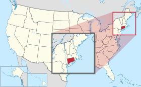
-
州都 ハートフォード 最大の都市 ブリッジポート[1] 州知事 ネッド・ラモント 公用語 英語(事実上)
法的指定なし面積
- 総計
- 陸地
- 水域全米第48位
14,357 km²
12,559 km²
1,809 km² (12.6%)人口(2020年)
- 総計
- 人口密度全米第29位
3,605,944人
287.1人/km²合衆国加入
- 順番
- 加入年月日
5番目
1788年1月9日時間帯 UTC -5
DST -4緯度 北緯40°58' - 42°3' 経度 西経71°47' - 73°44' 東西の幅 113 km 南北の長さ 177 km 標高
-最高標高
-平均標高
-最低標高
725 m
150 m
0 m略称 (ISO 3166-2:US) US-CTウェブサイト コネチカット州政府 上院議員 リチャード・ブルーメンタール
クリス・マーフィー


コネチカット州︵コネチカットしゅう、英: State of Connecticut、[kəˈnɛtɪkət] ( 音声ファイル), kuh-NET-i-kət[2]︶は、アメリカ合衆国北東部にあるニューイングランド地方では最南の州。州の北はマサチューセッツ州に接し、東はロードアイランド州に、西はニューヨーク州、南は大西洋に続くロングアイランド湾に接している。イギリスから最初に独立した13州のうちの一つ。日本語ではコネティカット州と書く場合もある。
概要[編集]
州都は保険の首都というニックネームを持つハートフォードだが、人口ではブリッジポート市が最多である。州の南部と西部はニューヨーク大都市圏に入っている。州内8郡のうち3郡は統計上ニューヨーク広域都市圏に含まれている。この広域都市圏は3州地域とも呼ばれる。コネチカット州の人口重心は、ニューヘイブン郡のチェシャーにあり[3]、その地点も3州地域に含まれている。 州名は、州をほぼ東西に二分するコネチカット川から採られており、﹁コネチカット﹂という言葉はこの地に先住したモヒガン族の言葉で、﹁長い川が流れる土地︵Quinnehtukqut︶﹂という意味である。 アメリカ合衆国50州の中で、人口では第29位だが、陸地面積では第48位︵ロードアイランド州、デラウェア州に次いで3番目に小さい︶であり、人口密度はニュージャージー州、ロードアイランド州、マサチューセッツ州に次いで第4位である。世帯当たり収入の中央値では第2位である。ニックネームは﹁憲法の州﹂、﹁ナツメグの州﹂、﹁堅い習慣の土地﹂と呼ばれ[4]、アメリカ合衆国連邦政府の発展に大きな影響を残した。 コネチカットとなった領域に最初に入ったヨーロッパ人はオランダ人であり、パーク川とコネチカット川の合流点、現在のハートフォードにフープ砦と呼ぶ小さな短命の開拓地を造った。当初、コネチカットの半分は、コネチカット川からデラウェア川までの大半を含むオランダ領ニューネーデルラントに属していた。 最初にできた大きな開拓地は1630年代のイングランドによるものだった。トマス・フッカーがマサチューセッツ湾植民地から1隊の追随者を陸路率いてきて、後にコネチカット植民地となるものを設立した。マサチューセッツからは別の開拓者がセイブルック植民地やニューヘイブン植民地を築いた。コネチカットとニューヘイブン両植民地は﹁基本的秩序﹂という文書を作成しており、これらは北アメリカで最初の憲法と考えられている。1662年、3つの植民地は王室チャーターの下に合併し、コネチカットを王室領植民地とした。 コネチカット川、テムズ川およびロングアイランド湾沿いの港によって強力な海洋国家が作られ、今日に至っている。その他の伝統的な産業は金融業であり、ハートフォードの保険会社やフェアフィールド郡のヘッジファンドが著名である。2010年国勢調査で、国内でも最大の一人当たり年収、0.962という高い人間開発指数、最大の世帯当たり収入中央値を示していた[5][6][7]。コネチカットは大半の指標で裕福な州だが、都市部と郊外部の収入格差が広がっている[8]。歴史[編集]
- 主要記事:コネチカット州の歴史

州名はアルゴンキン語で﹁長い川に沿った﹂を意味する言葉 "quinatucquet" を英語化したものである[10]。この地域をヨーロッパ人が植民地化する以前はモヒガン族インディアンが住んでいた。最初に探検したヨーロッパ人はオランダ人探検家のアドリアン・ブロックだった。1614年に探検した後、オランダ人毛皮交易業者がコネチカット川を遡り︵当時のオランダ人はバーシェリビア、すなわち﹁新鮮な川﹂と呼んでいた︶、現在のハートフォード、ダッチポイントに砦を築き、﹁希望の家﹂︵オランダ語: Huis van Hoop︶と呼んだ
当時マサチューセッツ湾植民地住民だったジョン・ウィンスロップが、1635年にコネチカット川河口のオールドセイブルックに新植民地を設立する許可を得た。これが後にコネチカット州を造り上げることになる3植民地の始まりとなった。セイブルック植民地は、オランダによる領有権主張と衝突していた。この植民地は小さな前進基地以上のものにはならず、成長しなかった。1644年セイブルック植民地はコネチカット植民地と合流した。
最初のイングランド人開拓者は1633年に入ってきてウィンザーに入植し、翌年にはウェザーズフィールドに入った[11]。しかし大集団で入ってきたのは1636年になってからだった。その開拓者はマサチューセッツのピューリタンであり、トマス・フッカーが率いていた。フッカーはイングランドの著名人であり、ケンブリッジでは神学教授だった。重要な政治的著述家であり、憲法理論に大きな貢献を果たした。ロジャー・ウィリアムズがロードアイランド植民地に新しい政体を造ったように、フッカーもマサチューセッツ湾植民地の指導層と訣別し、その追随者と共に1636年にハートフォードでコネチカット植民地を設立した。これが3植民地の2つめだった。
3番目のニューヘイブン植民地は1638年3月に、ジョン・ダベンポート、セオフィラス・イートンなどが設立した︵当初はキニピアック植民地と呼ばれていた︶。独自の憲法である﹁ニューヘイブン植民地の基本的合意事項﹂を作成し、1639年6月4日に署名が行われた。
マサチューセッツからのイングランド人開拓者が大挙流入したので、オランダは数で劣勢となり、1654年にその砦を放棄した。
コネチカット植民地もキニピアック植民地もイングランド王室の認可を得て設立されてはおらず、独立した政体だった。イングランドに従属すると見なされてはいたが、法的にはマサチューセッツ湾植民地から分離した前進基地に過ぎなかった。1662年、ウィンスロップがこの政治問題に関する法的な隙間を利用し、イングランドで認可を取得し、コネチカット植民地とキニピアック植民地を統合した。ウィンスロップが得た認可はコネチカット植民地に有利なものだったが、ニューヘイブンの町がハートフォードと共に植民地の首都となり、その状態はアメリカ独立戦争の後まで続いた。
ウィンスロップは政治的に大変明敏であり、新しく王座についたチャールズ2世から認可を得て、大変リベラルな政治的条件を認められた。
政治的に重要な植民地開拓地とその設立年は次の通りだった。
ウィンザー、1633年
ウェザーズフィールド、1634年
セイブルック、1635年
ハートフォード、1636年
ニューヘイブン、1638年
フェアフィールド、1639年
ギルフォード、1639年
ミルフォード、1639年
ストラットフォード、1639年
ファーミントン、1640年
スタンフォード、1641年
ニューロンドン、1646年
最初の憲法である﹁基本的秩序﹂は1639年1月14日に採択された。コネチカット州の現行憲法は1965年に採択された3代目である。コネチカット州はアメリカ合衆国憲法を批准した順番で、13州の中の5番目であり、アメリカ合衆国憲法の著者の1人がニューヘイブン出身のロジャー・シャーマンだったので、コネチカットの憲法はアメリカ合衆国憲法に影響を与えた。

1854年のニューロンドン
コネチカット州の西側州境は何度か修正された。1650年9月19日にオランダとの間に調印されたハートフォード条約により、コネチカットの西側境界はグリニッジ湾から北に20マイル (32 km)[12][13] を走り、﹁当該線がハドソン川から10マイル (16 km) 以内に入らないこと﹂とされた。この条約をイングランドは批准しなかった。この合意は1652年にイングランドとオランダの間に戦争が勃発するまで守られた。これ以外の規定は無かった。この不確かな境界に関して、1664年にヨーク公がニューネーデルラントを占領させた時まで紛争が続いた[12][13]。一方コネチカットが1662年に得ていた認可では、﹁南の海﹂すなわち太平洋まで続く全ての土地が認められていた[14][15]。このことで東西に長く伸びる帯状の土地が認められていた。コネチカットはこの認可を真面目に捉え、サスケハナ川とデラウェア川の間に、9番目の郡であるウェストモアランド郡を設立した。これがペンシルベニア州との間に短期間のペナマイト戦争を生じさせることになった。
コネチカット州の領土はオハイオ州北部を横切る形で伸びており、コネチカット西部保留地と呼ばれた。この土地はコネチカット州出身の人々が多く入植しており、コネチカットの地名をオハイオ州にもたらすことになった。ペンシルベニア州およびニューヨーク州との合意が成立して、コネチカット州による領有権主張が消滅し、現在州南西部にあるコネチカット・パンハンドル部ができた。西部保留地は連邦政府に譲渡され、マサチューセッツ州との州境微修正が行われた後で、現在の領域が確定した。

地理[編集]
- 主要記事:Geology of Connecticut
- 参照:コネチカット州の郡一覧


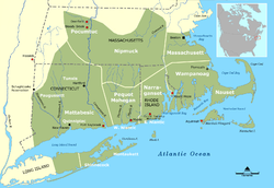
コネチカット州は、南はロングアイランド湾、西はニューヨーク州、北はマサチューセッツ州、東はロードアイランド州と接している。州都はハートフォード市であり、他の主要都市としては ブリッジポート、ニューヘイブン、スタンフォード、ウォーターベリー、ノーウォーク、ダンベリー、ニューブリテン、グリニッジ、及びブリストルがある。州内に総計169の法人化地方自治体がある。

ベア山、コネチカット州の最高峰

州内の最高地点、フリッセル山の南斜面にある。ベア山から望む
州内最高峰は州の北西隅、ソールズベリーにあるベア山である。コネチカット州、マサチューセッツ州、及びニューヨーク州の州境が交わる地点︵北緯42度3分‥西経73度29分︶の直ぐ東に最高地点がある。そこはマサチューセッツ州内に頂上があるフリッセル山の南斜面にある。
コネチカット川はカナダ国境からコネチカット州のロングアイランド湾岸へ流れていて、州の中央部を南北に貫いている。州内にある領域を中心とする最も人口の多い大都市圏はコネチカット川バレーにある。州域は小さいが、その風景には大きな変化がある。例えば、北西部のリッチフィールド丘陵では、うねりのある山地と馬牧場があり、南東部のニューロンドン郡では海浜と海洋活動が見られる。
コネチカット州は長い海洋活動の歴史があり、その歴史に基づく定評もあるが、実際には海に直接接していない。ニューヨーク州の海上州境がフィッシャー島の東まで延びており、そこでロードアイランド州との海上州境に接し、ナラガンセット湾を分けている。ロングアイランド湾やブロックアイランド湾を通じて容易に海に出られるが、直接大西洋には接していないことになる。
参照‥List of Connecticut rivers、List of Connecticut state forests
州内の北東部と北西隅にある田園地帯と小さな町は、ニューヨーク州境からニューロンドンに至る海岸道路や、コネチカット川をハートフォードまで遡る道沿いに並ぶ工業化された都市と大きな対照をなしている。リッチフィールド・グリーン、レバノン・グリーン︵州内最大の緑地︶、ウェザーズフィールド・グリーン︵州内最古の緑地︶など緑地を囲んで多くの町がある。この緑地近くには常にニューイングランの象徴とも言える白い教会、植民地時代の集会所、植民地風の酒場または宿屋、植民地時代の家屋数軒などがあり、歴史の保存のためにも観光のためにもその景観が維持されている。
州内には温帯性広葉樹林や混交林が多い。オーク、ヒッコリー、カエデなどの北東部海岸林が州の多くを覆っている[16]。州の北東部、タコニック山地ではニューイングランド・アカディア森林に移行している[16]。
マサチューセッツ州との北部州境には、サウスウィック・ジョグあるいはグランビー・ノッチと呼ばれる約2.5マイル (4.0 km) 四方の凹みがある。この変則点の起源は長い論争と一時的な合意の後に、最終的に1804年に決着して明確にされたものであり、サウスウィックの南部︵その住人はマサチューセッツ州からはなれようとしていた︶が半分に分けられた[17]。
州南西部のニューヨーク州と接するところは、フェアフィールド郡のパンハンドルと呼ばれ、グリニッジ、スタンフォード、ニューカナーン、ダリエンなどの町が入り、ノーウォークの一部もある。この変則性は17世紀にあった境界論争の結果であり、そこの住人がコネチカットに属すると考えていた地域をニューヨーク州が諦め、その代わりにリッジフィールドから北のマサチューセッツ州境まで伸びる帯状地と、論争には入っていなかったライの町を併せて、同等の領域を手に入れた[18]。
アメリカ合衆国国立公園局が維持している地域として、アパラチアン国立景観道、キネボーグ川とシェタケット川流域国立遺産回廊、ウェア農園国立歴史史跡がある[19]。


気候[編集]
州内の内陸は湿潤大陸性気候であり、海岸部︵南部4郡︶は温暖湿潤気候の境目にある。統計的にはこの気候帯に含められることも外されることもある。季節による温暖は大西洋に近接することで和らげられている。ロングアイランド湾沿いのブリッジポート市は、3州地域の他の部分と同様に、ケッペンの気候区分で温暖湿潤気候に入っている。35マイル (56 km) 内陸にあるハートフォードは、湿潤大陸性気候にある。海岸地域にあるという評価に違わず、日照時間はそこそこあり、年間2,400時間から2,800時間になっている[20]。 州全体で夏は暑く湿潤である。ニューロンドンで平均最高気温は81 °F (27 ℃)、ウインザーロックスでは87 °F (31 ℃) となっている。夏には日照が多いが、突然の雷雨で土砂降りとなることも多い。冬は概して冷涼から寒く、1月の平均気温は海洋の影響を受ける南東部で38 °F (3 ℃)、北西部で29 °F (−2 ℃) となる。年平均降雪量は、標高の高い北部で50ないし60インチ (125 – 150 cm)、南東部海岸地域で20ないし25インチ (50 – 63 cm) である。初春の4月は冷涼であり、晩春の5月から6月初めは暖かく、暑くなることもある。秋は温暖であり、10月や11月には州北部で紅葉が見られる。南部と海岸地域ではオークやヒッコリーが多くカエデが少ない。ハリケーンシーズンに時として熱帯低気圧に襲われることもある。雷雨は夏に多く、年平均で30回は発生している。その嵐は激しくなることもある。竜巻は年1回程度である[21]。過去最高気温は1995年7月15日にダンベリーで記録した106 °F (41 ℃)、過去最低気温は1943年2月16日のフォールズビレッジと、1961年1月22日にコベントリーで記録された-32 °F (-36 ℃) である[22]。| 州内各都市の月別平均最高最低気温 | ||||||||||||
| 都市 | 1月 | 2月 | 3月 | 4月 | 5月 | 6月 | 7月 | 8月 | 9月 | 10月 | 11月 | 12月 |
|---|---|---|---|---|---|---|---|---|---|---|---|---|
| ブリッジポート | 37/23 | 39/25 | 47/32 | 57/41 | 67/51 | 76/60 | 82/66 | 81/65 | 74/58 | 63/46 | 53/38 | 42/28 |
| ハートフォード | 35/16 | 39/19 | 47/27 | 59/38 | 70/48 | 79/57 | 84/63 | 82/61 | 74/51 | 63/40 | 52/32 | 40/22 |
| [23][24] | ||||||||||||
行政区分[編集]
詳細は「コネチカット州の郡一覧」を参照
重要な都市と町[編集]
都市・町名の後の数字は2020年国勢調査による人口(人)[25]
|
人口50,000人以上の都市 |
人口50,000人以上の町
|
コネチカット州の裕福な25都市[編集]
一人当たり収入による自治体の順位‥
(一)en:New Canaan, Connecticut 82,049米ドル
(二)en:Darien, Connecticut 77,519米ドル
(三)ウェストン (コネチカット州) 74,817米ドル
(四)グリニッジ (コネチカット州) 74,346米ドル
(五)ウエストポート (コネチカット州) 73,664米ドル
(六)ディープリバーセンター (コネチカット州) 72,261米ドル
(七)en:Wilton, Connecticut 65,806米ドル
(八)en:Fenwick, Connecticut 60,625米ドル
(九)en:Roxbury, Connecticut 56,769米ドル
(十)ジョージタウン (コネチカット州) 55,029米ドル
(11)en:Easton, Connecticut 53,885米ドル
(12)en:Essex Village, Connecticut 51,928米ドル
(13)リッジフィールド (コネチカット州) 51,795米ドル
(14)en:Avon, Connecticut 51,706米ドル
(15)en:Groton Long Point, Connecticut 51,066米ドル
(16)en:Redding, Connecticut 50,687米ドル
(17)ウッドブリッジ (コネチカット州) 49,049米ドル
(18)en:Sharon, Connecticut 45,418米ドル
(19)フェアフィールド (コネチカット州) 43,670米ドル
(20)en:Lyme, Connecticut 43,347米ドル
(21)エセックス (コネチカット州) 42,806米ドル
(22)en:Bridgewater, Connecticut 42,505米ドル
(23)en:Cornwall, Connecticut 42,484米ドル
(24)マディソンセンター (コネチカット州) 42,046米ドル
(25)en:Old Lyme, Connecticut 41,386米ドル
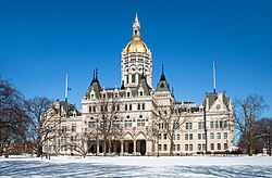
コネチカット州会議事堂、ハートフォード市中心街
1875年からハートフォード市が単一の州都となっている。それ以前はニューヘイブンも併せて2つの州都があった[26]。

ネッド・ラモント
コネチカット州知事が行政府の首長である。現知事はネッド・ラモント、副知事はスーザン・ビシエヴィッチであり、共に民主党員であり、就任日も2019年1月9日である。ネッドはコネチカット州州上院議員を務めた経験があり、2018年の州知事選挙に勝利し、2019年1月9日に就任した。1639年から1818年憲法の執行まで、州知事は議会を主宰していた。1974年、エラ・グラッソが州知事に当選し、その夫が州知事を経験していない女性としてはアメリカ合衆国初のことになった。
行政府には幾つかの部門がある。管理部、農業、金融、子供と家庭、消費者保護、矯正、経済と地域開発、開発サービス、建設、教育、緊急管理と公衆保護、エネルギーと環境保護、高等教育、保険、労働、精神医療と薬物対策、軍事、自動車、大衆保健、公共事業規制、公共事業、歳入、社会サービス、交通、退役兵の各部門である。さらに独立した部局、事務所、委員会がある[27]。
知事と副知事以外に、憲法に指定される4人の役員は直接選挙で選出される。すなわち州務長官、財務官、会計監査官、検察官である。任期は全て4年間である[26]。
政治と法律[編集]
関連項目‥Administrative divisions of Connecticut
憲法の歴史[編集]
コネチカット州は﹁憲法の州﹂として知られている。この称号の起源は明らかでないが、1638年から1639年に制定された﹁基本的秩序﹂に拠るか、1787年のアメリカ合衆国憲法制定会議における﹁大妥協﹂︵コネチカット妥協︶に拠るものと考えられている。これら﹁基本的秩序﹂がコネチカット州で代表制議会によって書かれた最初の公式政府を形作るものとなった。政府はコネチカット憲法の歴史の中で、4つの文書によって運営されてきた。基本的秩序の後、コネチカットは1662年のコネチカット・チャーターを通じて、イングランド王チャールズ2世により政府の権威を認められた。 この時期に政府の各府は存在せず、議会が最高権限をもって行動した。現在のアメリカ合衆国憲法に類似する憲法が制定されたのは、1818年になってからだった。現行憲法は1965年に制定されたものである。この1965年憲法は1818年憲法の大部分を踏襲したが、幾らかの重要な修正を加えた。 ﹁憲法の州﹂というニックネームが付けられた最もありそうな根拠は、1787年のアメリカ合衆国憲法制定会議において、コネチカットが重要な役割を果たしたというものである。このとき、州代表のロジャー・シャーマンとオリバー・エルスワースが、コネチカット妥協あるいは大妥協と呼ばれるようになるものを演出したからだった。その考え方はバージニア・プランやニュージャージ・プラント組み合わされ、両院制議会を作った。この形式はアメリカ合衆国憲法の採択以来、ほとんど各州の憲法で踏襲された。両院制議会についてはバージニア州とニュージャージー州から異なる形態が提案されていたが、コネチカットの提案は20世紀初期まで有効だった。アメリカ合衆国上院議員はこの時まで州議会によって選ばれていたが、州有権者によって直接選出されるよう修正された。その方式が現在も継続して採用されている。行政府[編集]

立法府[編集]
立法府はコネチカット州議会であり、定数36人の上院と同151人の下院の両院制である[26]。法として成立させるためには両院を通過しなければならない。州知事は拒否権を行使できるが、両院の3分の2以上の賛成があれば、この拒否が取り消される。州憲法により両院の議員は18歳以上である必要があり、偶数年11月にある選挙で、2年間任期で選出される。議員定数についても、上院は30人から50人、下院は125人から225人の間と決められている。副知事が上院議長となり、不在の場合は議長代行が主宰する。下院議長が下院を主宰する[28]。 地方政府の議会は市や町に係わる地方条例を定めている[29]。町の条例には、騒音規制や地区割りのガイドラインがふくまれることが多い[30]。しかし、コネチカット州も州全体に係わる騒音規制条例を作っている。司法府[編集]
コネチカット州の司法府で最高位にあるのがコネチカット州最高裁判所であり、首席判事が長である。法の合憲性、あるいは法の解釈に係わる事例を扱う。その手続きはアメリカ合衆国最高裁判所のものに類似し、証人による宣誓証言は無く、両側の弁護士は30分以内で論告を行う必要がある。法定手続きの後、判決までに数か月を要することがある。 1818年、裁判所は立法府や行政府とは独立した主体となった[31]。控訴裁判所は州全体に係わる下級審であり、上級裁判所は他州の郡裁判所に似た下級審である。 政策管理局を通じて逮捕令状の統計にアクセスできるようになっている[32]。地方政府[編集]
参照‥コネチカット州の郡一覧 アメリカ合衆国50州の中でコネチカット州とロードアイランド州のみが郡政府を廃止している。コネチカット州の場合は各郡で選出される保安官を除いて、1960年に郡政府を廃止した[33]。2000年、郡保安官が廃止され、州保安官の体系に置き換えられたが、その管轄範囲は旧郡の領域を踏襲している。裁判所の場合も地方裁判所は旧郡の領域にほぼ添った形で区分されている[34]。天気予報や国勢調査など統計的な目的では旧8郡の区分けが使われている。 コネチカット州ではニューイングランド・タウンと呼ばれる地方政府形態を採用している。州は基本的な政治区分となる169の町に分割されている[26]。市も21あり、その多くは同名の町と一体であり、市・町政府に統合されている。例外が2つある。グロトン市はグロトン町の1地区であり、ウィンステッド市はウィンチェスター町に入っている。法人化されたボロも9つあり、町の部分に対して付加サービスを行う[26][35]。唯一ノーガタックが町とボロの統合体である。 州は企画管理局が定義した15の計画地域に分けられてもいる[36]。ただしトランド郡のスタッフォードのみ例外である。この局の政府内制作部が、それら地域の管理主体と共に地域計画を調整している。各地域は地域統治委員会などと呼ばれる管理主体を持っている。この地域は、﹁地域と州の企画活動の協調、州内の地方計画地域の再設定と地域計画組織の継続、地域計画組織に対する技術支援と財政支援管理﹂のために設立された[36]。政治[編集]

登録有権者[編集]
コネチカット州民は有権者登録する際に、支持政党の宣言か支持政党無しの宣言を選択でき、また一定期間をおけば支持政党を変更できる。2013年時点で約58%が支持政党を登録しており、無党派と2大政党の支持率比を見ると、民主党支持7に対して無党派8、共和党支持4に対して無党派8となる。
少数政党の中ではリバタリアン党と独立党が2012年の大統領選挙にも出馬し、それぞれ0.81%と0.35%の支持を得た。
州内の多くの町はいずれの党でも中道を好む傾向がある。
| 登録有権者数、2012年10月30日[37] | ||||
|---|---|---|---|---|
| 政党 | 活動有権者 | 非活動有権者 | 有権者総数 | 比率 |
| 共和党 | 430,564 | 19,084 | 449,648 | 20.27% |
| 民主党 | 768,176 | 47,537 | 815,713 | 36.77% |
| 支持政党無し | 872,839 | 60,440 | 933,279 | 42.06% |
| 少数党 | 18,960 | 1,063 | 20,023 | 0.90% |
| 合計 | 2,090,539 | 128,123 | 2,218,662 | 100% |
共和党の地域[編集]
| 年 | 共和党 | 民主党 | ||
|---|---|---|---|---|
| Percent | Absolute | Percent | Absolute | |
| 2012年 | 40.73% | 634,892 | 58.06% | 905,083 |
| 2008年 | 38.22% | 629,428 | 60.59% | 997,773 |
| 2004年 | 43.95% | 693,826 | 54.31% | 857,488 |
| 2000年 | 38.44% | 561,094 | 55.91% | 816,015 |
| 1996年 | 34.69% | 483,109 | 52.83% | 735,740 |
| 1992年 | 35.78% | 578,313 | 42.21% | 682,318 |
| 1988年 | 51.98% | 750,241 | 46.87% | 676,584 |
| 1984年 | 60.73% | 890,877 | 38.83% | 569,597 |
| 1980年 | 48.16% | 677,210 | 38.52% | 541,732 |
| 1976年 | 52.06% | 719,261 | 46.90% | 647,895 |
| 1972年 | 58.57% | 810,763 | 40.13% | 555,498 |
| 1968年 | 44.32% | 556,721 | 49.48% | 621,561 |
| 1964年 | 32.09% | 390,996 | 67.81% | 826,269 |
| 1960年 | 46.27% | 565,813 | 53.73% | 657,055 |
フェアフィールド郡のニューケイナンやダリアンなど郊外町は州内でも共和党の支持が強い所と見なされている。東に数マイル離れた裕福な町ウェストポートは、民主党に忠実な町の1つと見なされることが多く、フェアフィールド郡のリベラルな町である。昔から共和党寄りだった裕福な町ウィルトンが、2008年の大統領選挙ではバラク・オバマに多数票を投じた。フェアフィールド郡の中では大きな富める町であるノーウォークとスタンフォードは、ジョン・G・ローランド元知事や、元アメリカ合衆国下院議員クリス・シェイズなど中道派共和党員を選んできたが、大統領選挙の年には民主党を選ぶ傾向があり、2008年にはシェイズが民主党のジム・ハイムズに敗れた。
州内の共和党寄りの地域は田園部でありリッチフィールド郡やハートフォード郡の西に隣接する町、ノーガタック川バレーの工業町、ニューヨーク州境に近いフェアフィールド郡の裕福な町の幾つかである。
リーバーマンの前任者ローウェル・P・ワイカー・ジュニアがアメリカ合衆国上院議員を務めた最後の共和党員になっている。ワイカーはリベラルな共和党員として知られた。ウォータゲート事件の時にリチャード・ニクソン大統領と袂を分かち、1990年には独立系のコネチカット党を創設して州知事選に出馬し当選した。ワイカー以前の共和党上院議員は1953年から1963年のプレスコット・ブッシュであり、元大統領ジョージ・H・W・ブッシュの父、ジョージ・W・ブッシュの祖父である。
民主党の地域[編集]
ウォーターベリーは登録有権者数で民主党が優勢だが、通常は二大政党の保守派候補者を選んでいる。ダンベリーでは、無党派層が二大政党の登録有権者数を上回っている。メリデン、ニューブリテン、ノーウィッチ、ミドルタウンなど小さな都市は民主党を好む。 2024年時点で、民主党が州選出連邦下院議員5人を独占している。最後の共和党の連邦下院議員クリス・シェイズは、2008年の選挙で敗北した。州選出の連邦上院議員は、2024年時点でリチャード・ブルメンソール︵民主党︶とクリス・マーフィー︵民主党︶である。近年の動向[編集]
2012年4月に両院で永劫に死刑制度を廃止する法案が成立した。当時死刑執行を待っていた死刑囚11人に対しては、現在も執行が可能である[39]。 2009年7月、国内でも初の公的医療保険改革法案﹁サスティネット﹂が成立し、これにジョディ・レル州知事が拒否権を使ったが、議会が拒否を差し戻した。 2008年11月12日、同性婚を認めた2番目の州になった︵第1番目はマサチューセッツ州︶。経済[編集]
アメリカ合衆国商務省経済分析局はコネチカット州の2010年総生産が2,370億米ドルだったと推計している[40]。2007年の一人当たり年収は64,833米ドルであり、国内第4位だった︵上位はワシントンD.C.、デラウェア州、アラスカ州︶。しかし州全体では所得格差が大きい。ニューケイナンは国内でも所得が高い町だが、ハートフォードは低い方の10傑に入る都市である。ブリッジポート、ニューヘイブンなどと同様、ハートフォードは裕福な郊外に囲まれている。2011年8月時点で州内の失業率は9.0%だった[41]。 ニューケイナンの一人当たり年収は85,459米ドルと州内最高であり、ダリアン、グリニッジ、ウェストン、ウェストポート、ウィルトンも65,000米ドル以上となっている。ハートフォードの一人当たり年収は2000年で13,428米ドルと州内最低だった[42]。州東部には収入の低いブルーカラーの町がある。主な会社など[編集]
コネチカット州に本拠地のある企業には以下のものがある。 上場企業 ●ゼネラル・エレクトリック︵NYSE: GE︶ ●ゼロックス︵NYSE: XRX︶ ●ハートフォード生命保険︵NYSE: HIG︶ ●ブッキング・ホールディングス︵NASDAQ: BKNG︶ 非上場企業 ●ESPN ●サブウェイ ●シコルスキー・エアクラフト ●ワールド・レスリング・エンターテイメント税[編集]
コネチカット州は1991年まで投資のみに所得税が掛かった。被雇用者の収入は非課税だが、投資からの収入には13%が課され、国内最高だった。借入金に対する支払利子など投資のコストは控除されなかった。 1991年、独立党の州知事ローウェル・P・ワイカー・ジュニアがこの税制を変更し、被雇用者の収入も投資の収入も一律最大4%とした。このときからグリニッジはアメリカ最大の多くのヘッジファンドの拠点になった。2011年時点で所得税は3%から6.7%までの6段階累進課税となっている[43]。州民が得た賃金は、それが州外から稼いだものでも所得税の対象になる。しかし、他州で課される税額をコネチカット州の税額が超えるときのみ課税される。ニューヨーク州やマサチューセッツ州はコネチカット州より税率が高いので、他州で働く州民はコネチカット州の所得税を払わなくて済むことになる。コネチカット州は他州に支払った税の控除を認めているが、他州で支払った税額がコネチカット州の税額を超えない場合はコネチカット州の所得税を支払わなければならない。 消費税は6.35%であり、大半の商品の販売、リース、レンタルに課される[43]。特定商品とサービスは、法によって課税対象とされていない限り免税である。50米ドル未満の衣類は免税だったが2011年7月に撤廃された[43]。地方政府が消費税を付加することはない。夏季に、学校へ戻る子供達を支援するために、特定アイテムと量の衣料は1週間のみ非課税である。 州内にある全ての不動産個人資産は、法によって免税とされない限り資産税の対象である。評価額は公平市場価値の70%である。ただし、地方政府からさらに20%が加算されることもある。最大控除額は500米ドルであり、過剰額が返還されたり先送りされたりすることはない[44]。税務基金に拠れば、2010年国勢調査で、コネチカット州民はニュージャージー州に次いで2番目に高い資産税を支払っている[45]。不動産[編集]
コネチカット州の住宅は高低の差が広いが、中央値は約226,000米ドルである。例えばフェアフィールド郡の住宅価格中央値は約37万米ドルである[46][47]。北東部では最も数百万ドルの住宅が多く、国内ではカリフォルニア州に次いで多い。2003年で100万ドルを超える住宅は3.3%だった[48]。産業[編集]
州内の農水産物としては、苗、卵、ハマグリとロブスター︵甲殻類︶、酪製品、牛、タバコがある。工業製品としては輸送機器、特にヘリコプター、航空機部品、原子力潜水艦、重工業機械と電気機器、兵器、加工金属製品、化学品と薬品、計測機器がある。昔から銃製造の中心地であり、2012年12月時点で銃メーカー4社、すなわちコルト、スタッグ、ルガー、モスバーグがあり、2,000人を雇用し、操業を続けている[49]。レミントンが所有していたマーリンは2011年4月に閉鎖された[50]。 州内で航空産業が盛んなので、州の公式航空機はF4U コルセア、公式飛行機パイオニアはイーゴリ・シコールスキイになっている。1901年にブリッジポート市で動力飛行をおこなったグスターヴ・ホワイトヘッドは﹁コネチカット航空術の父﹂と認定されている[51][52][53][54]。1964年8月15日︵ホワイトヘッドの墓に記念の墓石を置いたとき︶、また1968年8月14日︵ホワイトヘッドの最初の動力飛行の日を認定するために︶、ジョン・デンプシー州知事が﹁グスタブ・ホワイトヘッドの日﹂を宣言した[55][56]。 コネチカット州の海岸町では牡蠣が重要な収入源だった。19世紀、ニューヘイブン、ブリッジポート、ノーウォークで牡蠣漁が最盛期となり、近くの町でもそこそこの成功を収めた。1911年、牡蠣の生産量がピークとなり、牡蠣の肉だけで年間2,500万ポンド (11,000 トン) 近くになった。当時はニューヨーク州、ロードアイランド州、マサチューセッツ州の生産高よりも多かった[57]。このころ、コネチカット州の海岸は﹁世界の牡蠣の首都﹂と呼ばれた。1969年まで、第一次世界大戦前に成立したコネチカット州法で、州が所有する岩礁での牡蠣収穫量を制限していた。この法によってスループ船の建造が促進された[58]。1948年にグリニッジで建造されたスループ船ホープは、コネチカット州で建造された最後の牡蠣用スループ船と見られている。 2006年12月7日にコネチカット州文化観光委員会が発行した報告書では、芸術、映画、歴史観光で生みだされた経済効果は140億米ドル以上となり、年間17万人の職を維持していた。このことで個人所得に90億米ドル、州や地方政府の歳入に17億米ドルが入った[59]。住民[編集]
人口動態[編集]
| 人口推移 | |||
|---|---|---|---|
| 年 | 人口 | %± | |
| 1790 | 237,946 | — | |
| 1800 | 251,002 | 5.5% | |
| 1810 | 261,942 | 4.4% | |
| 1820 | 275,248 | 5.1% | |
| 1830 | 297,675 | 8.1% | |
| 1840 | 309,978 | 4.1% | |
| 1850 | 370,792 | 19.6% | |
| 1860 | 460,147 | 24.1% | |
| 1870 | 537,454 | 16.8% | |
| 1880 | 622,700 | 15.9% | |
| 1890 | 746,258 | 19.8% | |
| 1900 | 908,420 | 21.7% | |
| 1910 | 1,114,756 | 22.7% | |
| 1920 | 1,380,631 | 23.9% | |
| 1930 | 1,606,903 | 16.4% | |
| 1940 | 1,709,242 | 6.4% | |
| 1950 | 2,007,280 | 17.4% | |
| 1960 | 2,535,234 | 26.3% | |
| 1970 | 3,031,709 | 19.6% | |
| 1980 | 3,107,576 | 2.5% | |
| 1990 | 3,287,116 | 5.8% | |
| 2000 | 3,405,565 | 3.6% | |
| 2010 | 3,574,097 | 4.9% | |
| 2020 | 3,605,944 | 0.9% | |
| Sources:[60][61][62] | |||

2012年7月1日時点の推計によるコネチカット州の人口は3,605,944人となっていた。2010年国勢調査での3,574,097人からは31,847人、0.89%増加していた[25]。
コネチカット州の人口重心はチェシャー町となっている[63]。
年齢構成を見ると、5歳未満が人口の6.6%、18歳未満が同24.7%、65歳以上が13.8%だった。性別比では女性が51.6%、男性が48.4%だった。
1790年、州人口の97%は﹁田舎者﹂に分類されていた。これが半分以下になったのは1890年の国勢調査からだった。2000年国勢調査では僅か12.3%になった。州西部と南部の大半︵コネチカットのゴールドコースト︶はニューヨーク市との結びつきが強い。この地域は州内でも豊かで人口の多い地域である。州東部は文化的にボストン市やプロビデンス市などニューイングランドとの結びつきが強い。

人種や民族で多数となるものの分布図、2010年
同州近辺のかつてのインディアン部族の勢力図

コネチカット州のインディアン保留地︵クリックで拡大表示︶

ニューロンドン郡︵赤い部分︶のレッドヤードに﹁マシャンチケット・ ペコー族﹂の保留地、ウンカスヴィルに﹁モヘガン族﹂の保留地がある
かつてマヒカン族、モヘガン族、西ニアンチック族、ニプマク族、ピクォート族、ワッピンガー族の6つのインディアン部族が先住したが、そのほとんどがアメリカ政府に虐殺され、19世紀に他州へと強制移住させられた。残る部族も1950年代から﹁絶滅した﹂としてアメリカ連邦政府からインディアン部族としての公式認定を打ち切られて﹁保留地︵Reservation︶﹂を没収され、連邦条約で確約された福利厚生などのサービスも打ち切られた。
連邦政府は公認していないが、コネチカット州が独自に部族認定した部族もある。コネチカット州の州政府公認部族はある程度の自治権を持つ﹁州立保留地﹂を持っている。
同州に先住するインディアンは、連邦や州との交渉事務のために﹁コネチカットインディアン事務会議︵CIAC︶﹂を組織運営している。
マシャンチケット・ペコー族は、ピクォート戦争で虐殺され、1666年にコネチカット入植政府から3.47エーカー︵0.014km2︶の領土を﹁与えられた﹂。その後部族の領土は略奪され続けて1エーカー未満となり、20世紀初頭には部族も絶滅したことにされた。後に部族は土地を買い戻し続け、一方で土地の不法略奪を連邦に提訴した。これに勝訴した彼らは、1976年に晴れて連邦から再公認されて﹁復活﹂。5.6km2まで買い戻した彼らの土地は連邦の信託する土地︵Reservation︶となった。
ケント郡のシャーチコーク部族国家は、西コネチカットでの部族カジノ建設構想の必須条件として、アメリカ連邦政府による公認を要求中である。しかし2008年8月、ピーター・C・ドーシー地区判事は、彼らの申請を却下するアメリカ内務省の2005年の決定を支持した。シャーチコーク族代表と弁護団は、この決定を覆せなかった。
ドーシー判事は判決で、シャーチコーク族に対するマシャンチケット・ペコー族とモヘガン族の議会での妨害工作を認めたが、シャーチコーク族側が、﹁インディアン部族として、歴史的に血筋が明瞭に続いている部族グループである﹂ということを証明できなかったため、内務省決定を有効とした、と述べた。
ブルーメンタール州司法長官は﹁今日の勝利は、現実の再確認であって、シャーチコーク族の連邦公認申請は失敗しましたが、それはメリットのないものだからです。部族の主権獲得は、連邦基準を明らかに満たせる者たちだけのものでなければなりませんし、シャーチコーク族はそれらの基準を満たせなかったのです﹂とコメントした。2009年8月に、彼らは再びピーター・C・ドーシー地区判事によって申請を却下されている。
人種及び祖先[編集]
2010年国勢調査に拠れば、コネチカット州の人種による人口構成は次のようになっている[64]。 ●77.6% 白人︵ヒスパニック以外の白人は71.2%︶ ●10.1% 黒人 ●3.8% アジア人 ●0.3% インディアン ●0.0% 太平洋諸島系 ●5.6% その他の人種 ●2.6% 混血 ●13.4% ヒスパニック︵人種によらない︶ 非ヒスパニック白人は1940年の98%から2010年の71%まで比率が落ちてきた[65]。 2004年時点で、人口の11.4%︵400,000人︶は外国生まれであり、外国生まれの10%は不法在留外国人︵人口の約1.1%︶である。1870年には国内で生まれたアメリカ人が75%いたが、1918年には35%まで落ちていた。 2000年時点で、5歳以上のコネチカット州民の81.69%は家庭で英語を話し、8.42%はスペイン語、イタリア語は1.59%、フランス語1.31%、ポーランド語1.20%となっていた[66]。 2000年時点で、コネチカット州で申告された祖先による構成比は、以下の通りだった[67]。 ●19.3% イタリア系 ●17.9% アイルランド系 ●10.7% イギリス系 ●10.4% ドイツ系 ●8.6% ポーランド系 ●6.6% フランス系 ●3.0% フランス系カナダ人 ●2.7% アメリカ人 ●2.1% ロシア系 ●2.1% 西インド諸島系 ●2.0% スコットランド系 ●2.0% スウェーデン系 ●1.6% ポルトガル系 ●1.4% スコットランド・アイルランド系 ●1.2% ハンガリー系 ●1.0% リトアニア系 州内にはイタリア系、アイルランド系、イギリス系さらにドイツ系が多く、ポルトガル系の場合はロードアイランド州に次いで高い比率になっている。イタリア系は州内5つの郡で最大比率であり、アイルランド系はトランド郡で最大、フランス系カナダ人はウィンダム郡で最大となっている。アフリカ系とヒスパニック系︵特にプエルトリコ系︶は都市部で多い。ハンガリー系が多いことでも知られ、その過半数はフェアフィールド、スタンフォード、ノーガタック、ブリッジポートとその周辺に多い。ポーランド系がかなりおり、ニューブリテンには州内で最大の数がいる。 近年の移民では、インド、フィリピン、ラオス、ベトナム、タイ、インドネシア、メキシコ、ブラジル、グアテマラ、パナマ、ジャマイカ、ハイチ、カーボベルデからが多く、また旧ソビエト連邦からも目に付く。 2011年時点で、1歳未満の州民の46.1%は少数民族の子供だった[68]。
宗教[編集]
2001年時点で、コネチカット州民の宗教宗派別構成比は次のようになっている[69]。 ●キリスト教 – 79% ●プロテスタント – 47% ●バプテスト – 10% ●米国聖公会 – 6% ●メソジスト – 4% ●ルーテル教会 – 4% ●会衆派/キリスト合同教会 – 2% ●他のプロテスタントまたは一般的なプロテスタント – 21% ●ローマ・カトリック – 32% ●他のキリスト教 – 1% ●ユダヤ教 – 3% ●他の宗教 – 4% ●無宗教 – 12% 州内はかなりのユダヤ教人口がおり、2000年には108,280人、3.2%だった[70]。ロングアイランド湾に近いグリニッジとニューヘイブンの間、ニューヘイブン大都市圏、ハートフォード大都市圏特にウェストハートフォードの郊外に多くが集中している。宗教データアーカイブ協会に拠れば、2000年時点で最大の宗派は、1,372,562人のカトリック教会であり、続いて124,770人のユナイテッド・チャーチ・オブ・クライスト、73,550人の米国聖公会となっていた[70]。 最近の移民はこの州にキリスト教以外の宗教を持ち込んでいるが、他の宗教の信仰者数はまだ少ない。 州内にはハートフォード郡ブルームフィールドの第一カセドラルのように、ニューイングランドでは最大のプロテスタント教会がある。 ハートフォードはローマ・カトリック教会ハートフォード大教区の本部であり、ブリッジポート教区とノーウィッチ教区を管轄している。インディアン部族[編集]


|
≪アメリカ連邦政府が承認しているインディアン部族≫ ≪アメリカ連邦政府は承認していないが、コネチカット州政府は公認している部族≫ |
≪現在連邦承認を要求中の部族≫ |
インディアン・カジノ[編集]
1960年代に始まるインディアン権利回復運動の中で、部族の再認定要求も高まり、1976年に﹁マシャンチケット・ピクォート族﹂が再認定され﹁復活﹂、1992年にインディアン・カジノの﹁フォックスウッズ・リゾート・カジノ﹂を開設し、大成功を収めている。同州の﹁インディアン・カジノ﹂は、このカジノと併せ、二つのみ。﹁フォックスウッズ・リゾート・カジノ﹂のスロットマシンは6200台を数え、世界最大級の規模を誇る。
≪コネチカット州のインディアン・カジノ≫
- 「フォックスウッズ・リゾート・カジノ」 - マシャンチケット・ペコー族が経営
- 「モヘガン・太陽のカジノ」 - コネチカット・モヘガン族が経営
交通[編集]
詳細は「w:Transportation in Connecticut」を参照

道路[編集]
州内を走る州間高速道路は、海岸沿いを南西から北東に走る95号線︵コネチカット・ターンパイク︶、州中央部を南西から北東に走る84号線、州中央部を北から南に走る91号線、東部州境を北から南に走る395号線がある。その他の幹線道として、メリット・パークウェイとウィルバー・クロス・パークウェイがあり、コネチカット州道15号線となって、ニューヨーク州のハッチンソン川パークウェイから州間高速道路95号線と並行に走り、北へ曲がってニューヘイブンに向かい、州間高速道路91号線に並行し、最後はバーリンで平面道路となる。州道15号線と州間高速道路95号線は有料道路だった。全ての車が止まって料金を払う料金所のシステムに依存していた。この料金所で大きな事故が続き、1988年に料金徴収を止めた[71]。その他の主要道として、ニューヨーク州境を走るアメリカ国道7号線、その東の工業都市ウォーターバリーを通り国道7号線にほぼ並行してノーガタック川バレーを南北に走る国道8号線、東部の同9号線がある。
ニューヘイブンとニューヨーク市を繋ぐ州間高速道路95号線は国内でも最大級に通行量の多い道路である。多くの人々が長距離を走ってニューヨーク市に通勤している。このために片側3車線の道路が一杯となり、渋滞を生んでいる。並行するメリット・パークウェイにも混雑が及ぶことが多い。州は鉄道の利用や乗り合いなど交通量の削減を図っている[72]。
州内には自転車の愛好家が多く、国内でも最大級の自転車所有率と利用率がある。ニューヘイブンの自転車愛好組織はエルムシティサイクリングという地元団体が設立し、特に活動的である。2006年アメリカン・コミュニティ・サーベイに拠れば、ニューヘイブンは東海岸で最も自転車を通勤に利用する人の比率が高い。
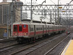
メトロノース鉄道ニューヘイブン線の電車、スタンフォード

鉄道[編集]
州南西部はメトロノース鉄道ニューヘイブン線が通り、ニューヘイブンからニューヨーク市まで通勤できる。ニューカナーン、ダンベリー、ウォーターベリーへの支線もある。アムトラックでは北東回廊線にあり、ノースイースト・リージョナルやアセラ・エクスプレスが走っている。ニューヘイブンとニューロンドンの間にある町はショアライン・イーストの通勤線を利用できる。ニューヘイブンからスプリングフィールドまで、アムトラックのニューヘイブン・スプリングフィールド線を使った通勤鉄道が計画中である[73]。アムトラックはニューヘイブンとスプリングフィールドの間でシャトル便の運行も行っており、回廊沿いのハートフォードなどに停車している。バス[編集]
州全体のバス便はコネチカット州交通省が所有するコネチカットトランジットが運行しており、また小さな自治体も地方便を運行している。バス網は州内交通の重要部であり、特にハートフォード、スタンフォード、ノーウォーク、ブリッジポート、ニューヘイブンなど都市部で重要である。ニューブリテンからハートフォードまで高速バス用道路を建設する3か年計画が2009年8月に始まった[74]。空港[編集]
ブラッドレー国際空港がハートフォードの北15マイル (24 km) のウィンザーロックスにある。地域連絡便はツウィード・ニューヘイブン地域空港が利用できる。大きな市民空港としては、州西部にダンベリー市民空港とウォーターベリー・オックスフォード空港が、東部にはグロトン・ニューロンドン空港がある。シコルスキー記念空港がストラットフォードにあり、貨物便、ヘリコプター、民間機が利用している。フェリー[編集]
ロッキーヒル・グラストンベリー・フェリーとチェスター・ハドライム・フェリーがコネチカット川を渡している。ブリッジポート&ポートジェファーソン・フェリーは、ロングアイランド湾のブリッジポート市とポートジェファーソンの間を渡している。ニューロンドンからニューヨーク州のオリエント、フィッシャーズ島、ブロック島に渡すフェリーもある。教育[編集]
初等中等教育[編集]
コネチカット州教育委員会が幼稚園から12年制までの公立学校体系を管理している。委員は州知事から指名される。各学校に関する統計は﹁シーダー﹂と呼ばれるオンライン・データベースで公開されている[75][76]。単科及び総合大学[編集]
コネチカット州には国内初の法学校であるリッチフィールド法学校があり、1773年から1883年にリッチフィールドで運営された。ハートフォード公立高校は1638年に設立され国内では3番目に古い高校である。芸術・文化[編集]
スポーツチーム[編集]
●コネチカット・サン (WNBA) ●ハートフォード・ウルフパック (AHL) マイナーリーグチーム‥ ●ブリッジポート・ブルーフィッシュ ●en:Norwich Navigators ●ハートフォード・ヤードゴーツ州立公園[編集]

その他[編集]
出身著名人[編集]
●ヘンリー・クレイ・ワーク - 作詞家・作曲家 ●チャールズ・アイヴズ - 作曲家 ●ウィリアム・ウィリアムス - アメリカ独立宣言署名者 ●ノア・ウェブスター - 辞書編纂者・教育者 ●ジョナサン・エドワーズ - 神学者 ●ブラッド・オースマス - 野球選手 ●ジム・オルーク - 野球選手・監督 (アメリカ野球殿堂表彰者) ●カーイン - 実業家 ●カレン・カーペンター - ヴォーカリスト・ドラマー ●リチャード・カーペンター - 音楽プロデューサー・アレンジャー・ピアニスト ●チャールズ・グッドイヤー - 発明家。加硫ゴムを発明。 ●ロジャー・コナー - 野球選手・監督 (アメリカ野球殿堂表彰者) ●サミュエル・コルト - リボルバー拳銃発明者 ●ハリエット・ビーチャー・ストウ - ストウ夫人として知られる。アンクル・トムの小屋の作者。 ●チャールズ・ルイス・ティファニー - ティファニー創設者 ●ラルフ・ネーダー - 弁護士・社会運動家 ●ホーレス・H・ハイデン - 歯科医師、歯科教育者。ボルティモア歯科医学校の創立者の一人。 ●モーガン・バークリー - 政治家・球団経営者。MLBナショナルリーグ初代理事長 (アメリカ野球殿堂表彰者) ●P・T・バーナム - 興行師 ●ボビー・バレンタイン - 野球選手・監督 ●ネッド・ハンロン - 野球選手・監督 (アメリカ野球殿堂表彰者) ●キャサリン・ヘプバーン - 女優 ●ダナ・ホワイト - 総合格闘技団体﹁UFC﹂代表 ●ジョージ・W・ブッシュ - 第43代アメリカ合衆国大統領 ●シェイン・マクマホン - WWE副社長 ●ステファニー・マクマホン - WWE副社長 ●ジョン・メイヤー - シンガーソングライター ●ヴィンス・メンドーザ - 作曲家・編曲家 ●ジョン・モルガン - モルガン財閥創始者 ●クリストファー・ロイド - 俳優 ●ジョージ・ワイス - 球団経営者 (アメリカ野球殿堂表彰者 ●ジョーイ・ロガーノ-ナスカーレーシングドライバー州の象徴など[編集]
●州の鳥 - コマツグミ ●花 - アメリカシャクナゲ ●州の木 - ホワイトオーク ●州のモット- Qui Transtulit Sustinet日本の姉妹都市[編集]
●神奈川県厚木市 - ニューブリテン市、1983年 ●長崎県長与町 - ウェザースフィールド町、1996年事件[編集]
●サンディフック小学校銃乱射事件 - 26人が死亡した銃乱射事件︵スクールシューティング︶脚注[編集]
(一)^ Population Estimates for All Places: 2000 to 2006: Connecticut SUB-EST2006-04-09.xls. United States Census Bureau. Retrieved October 16, 2007.
(二)^ “Connecticut - Definitions from Dictionary.com”. 2010年11月18日時点のオリジナルよりアーカイブ。2007年9月17日閲覧。
(三)^ “State of Connecticut Center of Population - From ngs.noaa.gov”. 2010年11月18日時点のオリジナルよりアーカイブ。2009年1月30日閲覧。
(四)^ “Sites, Seals & Symbols”. SOTS. The Government of Connecticut. 2008年6月12日閲覧。
(五)^ Ohlemacher, Stephen (2005年11月29日). “Highest wages in East, lowest in South”. USA Today. オリジナルの2010年11月18日時点におけるアーカイブ。 2010年4月30日閲覧。
(六)^ “Census 2000”. United States Census Bureau (2000年3月18日). 2010年11月18日時点のオリジナルよりアーカイブ。2013年8月13日閲覧。
(七)^ “US slips down development index”. BBC. (2008年7月17日). オリジナルの2010年11月18日時点におけるアーカイブ。
(八)^ “Income Gap in Connecticut Is Growing Fastest, Study Finds”. The New York Times. (2008年4月9日)
(九)^ MLA Language Map Data Center". Modern Language Association.
(十)^ Federal Writers' Project. Connecticut: A Guide to Its Roads, Lore and People. US History Publishers. p. 3. ISBN 978-1-60354-007-0 2010年9月23日閲覧。
(11)^ “Early Settlers of Connecticut”. Connecticut State Library. 2010年7月25日閲覧。
(12)^ abBowen, Clarence Winthrop (1882), Boundary Disputes of Connecticut, Boston, Massachusetts, pp. 17–18.
(13)^ abFlick, Alexander C, ed. (1933–37), History of the State of New York, 2, New York City: Columbia University Press, pp. 50–57.
(14)^ Callison, James (2006年3月14日). “Connecticut Colony Charter of 1662”. US history. OU. 2010年7月25日閲覧。
(15)^ Lacey, Barbara, “Migration from Connecticut”, Encyclopedia (topical survey), Connecticut's Heritage Gateway.
(16)^ abOlson, D. M, E. Dinerstein et al. (2001). “Terrestrial Ecoregions of the World: A New Map of Life on Earth”. BioScience 51 (11): 933–938. doi:10.1641/0006-3568(2001)051[0933:TEOTWA]2.0.CO;2. ISSN 0006-3568. オリジナルの2010-11-18時点におけるアーカイブ。.
(17)^ “Connecticut's Southwick Jog”. Connecticut State Library. 2010年11月18日時点のオリジナルよりアーカイブ。2013年8月13日閲覧。
(18)^ “Connecticut's "Panhandle"”. Connecticut State Library. 2010年11月18日時点のオリジナルよりアーカイブ。2013年8月13日閲覧。
(19)^ “Connecticut”. National Park Service. 2008年7月15日閲覧。
(20)^ “United States annual sunshine map”. HowStuffWorks. 2011年3月15日閲覧。
(21)^ “Annual average number of tornadoes” (GIF). NOAA National Climatic Data Center. 2006年10月24日閲覧。
(22)^ “All-Time Climate Extremes for CT”. NOAA. 2011年3月18日閲覧。
(23)^ “Monthly Averages for Bridgeport, CT”. The Weather Channel. 2011年9月15日閲覧。
(24)^ “Monthly Averages for Hartford, CT”. The Weather Channel. 2011年9月15日閲覧。
(25)^ abQuickFacts. U.S. Census Bureau. 2020年.
(26)^ abcde“About Connecticut”. The Government of Connecticut. 2005年12月18日閲覧。
(27)^ “Connecticut's Executive Branch of Government”. ct.gov. 2013年8月13日閲覧。
(28)^ Constitution of the State of Connecticut, Connecticut: Secretary of State 2012年4月30日閲覧。.
(29)^ “Ordinances and Charters by Town – Judicial Branch Law Libraries”. Judiciary. 2013年6月10日閲覧。
(30)^ Town of Newtown, CT (2010年8月20日). “Noise Control Ordinance”. The Government of Newtown. 2013年6月10日閲覧。
(31)^ History of the Connecticut Courts. Last retrieved February 20, 2007.
(32)^ Enter your Company or Top-Level Office (2013年5月15日). “OPM: Arrest Warrant Data”. Ct.gov. 2013年6月10日閲覧。
(33)^ “Connecticut State Register and Manual: Counties”. 2006年10月10日時点のオリジナルよりアーカイブ。2006年11月7日閲覧。
(34)^ “State of Connecticut Judicial Branch”. Jud.ct.gov. 2010年7月25日閲覧。
(35)^ Connecticut's Boroughs and Cities. Connecticut State Library. Retrieved January 20, 2007.
(36)^ abEnter your Company or Top-Level Office. “Regional Planning Coordination at the CT Office of Planning and Management”. Ct.gov. 2010年7月25日閲覧。
(37)^ “Registration and Party Enrollment Statistics as of October 30, 2012” (PDF). Connecticut Secretary of State. 2013年5月10日閲覧。
(38)^ “Presidential General Election Results Comparison – Connecticut”. Dave Leip's Atlas of United States Presidential Elections (2005年). 2007年1月20日閲覧。
(39)^ “Connecticut governor signs bill to repeal death penalty”. FOX News Network. (2012年4月25日) 2012年4月25日閲覧。
(40)^ “GDP by State”. Greyhill Advisors. 2011年9月23日閲覧。
(41)^ “Local Area Unemployment Statistics”. BLS. 2011年9月23日閲覧。
(42)^ “Connecticut per capita income, median household income, and median family income at State, County and Town level: Census 2000 data” (XLS). State of Connecticut. 2010年7月25日閲覧。
(43)^ abc Summary of Tax Provisions Contained in 2011 Conn. Pub. Acts 6, The State of Connecticut 2011年7月6日閲覧。.
(44)^ “Connecticut income tax instructions” (PDF). 2010年11月13日時点のオリジナルよりアーカイブ。2010年7月25日閲覧。
(45)^ Christie, Les (2010年9月30日). “Highest property taxes in the nation”. CNN 2010年9月30日閲覧。
(46)^ “Conn. Median Home Prices Down 18% in First quarter”. The Warren group (2009年5月4日). 2010年7月25日閲覧。
(47)^ “CT house prices continue to fall”. Hartford Business. 2010年7月25日閲覧。
(48)^ Christie, Les (2006年2月23日). “Million Dollar Homes”. CNN 2007年1月23日閲覧。
(49)^ Rivera, Ray; Cowan, Alison Leigh (2012年12月23日). “Gun Makers Use Home Leverage in Connecticut”. The New York Times 2012年12月24日閲覧。
(50)^ Sturdevant, Matthew (2011年4月1日). “Marlin Firearms Closes In North Haven, Ending 141 Years of Manufacturing In Connecticut”. The Hartford Courant
(51)^ O'Dwyer, Maj. William J. (October 1998). “The "Who Flew First" Debate”. Flight Journal (Air Age Media). オリジナルの2006-12-07時点におけるアーカイブ。 2007年1月23日閲覧。.
(52)^ Witkowski, Mary K, Images of America – Bridgeport At Work, p. 85.
(53)^ All the World Aircraft Executive Overview, Jane's, (Mar. 8, 2013).
(54)^ Whitehead first to fly, “Aviation bible”, The CT post.
(55)^ O'Dwyer; Randolph (1978), History by Contract, pp. 192–94.
(56)^ Delear, Frank (March 1996). “Gustave Whitehead and the First-Flight Controversy”. Aviation History 2007年1月23日閲覧。.
(57)^ [1] Ct history.org "Oystering in CT, from Colonial Times to the 21st Century"
(58)^ This Fine Piece of Water: An Environmental History of Long Island Sound. Tom Andersen. p.90
(59)^ (PDF) The Economic Impact of the Arts, Film, History, and Tourism Industries in Connecticut (Highlights), Connecticut: Commission on Culture and Tourism.
(60)^ “1790 to 1990”, Population, Census.
(61)^ Resident Population of the 50 States, the District of Columbia, and Puerto Rico, Census, (2000).
(62)^ “Resident Population Data”. Census (2010年). 2011年1月23日閲覧。
(63)^ “Population and Population Centers by State”. United States Census Bureau (2000年). 2010年1月17日時点のオリジナルよりアーカイブ。2008年12月4日閲覧。
(64)^ Fact finder, United States of America: Census bureau.
(65)^ “Connecticut – Race and Hispanic Origin: 1790 to 1990”. US Census Bureau. 2012年4月18日閲覧。
(66)^ “Most spoken languages in Connecticut”. Language Map. The Modern Language Association. 2007年9月30日時点のオリジナルよりアーカイブ。2007年1月16日閲覧。
(67)^ “American Community Survey 3-Year Estimates”. American FactFinder. Census Bureau. 2010年7月25日閲覧。
(68)^ Exner, Rich (2012年6月3日). “Americans under age 1 now mostly minorities, but not in Ohio: Statistical Snapshot”. The Plain Dealer
(69)^ “American Religious Identification Survey, Key Findings, Exhibit 15”. City University of New York (2001年). 2007年1月4日閲覧。
(70)^ ab“Kansas: Denominational Groups”, Maps & Reports (state membership report), The Association of Religion Data Archives, (2000).
(71)^ Connecticut Turnpike (I-95), NYC roads.
(72)^ “CT rides” (2010年4月15日). 2010年7月25日閲覧。
(73)^ “NHHS Rail”. NHHS Rail (2010年7月19日). 2011年9月15日閲覧。
(74)^ "New Britain-to-Hartford 'Busway' Receives Final Federal Design Approval" (Press release). State of Connecticut. 31 October 2006. 2007年1月29日閲覧。
(75)^ “CEDaR”. State Department of Education. Government of Connecticut. 2013年6月10日閲覧。
(76)^ (PDF) Resc Alliance (brochure), Aces, (2011)
(77)^ Rankings, U Conn.
関連項目[編集]
外部リンク[編集]
- 政府
- Connecticut State Databases – Annotated list of searchable databases produced by Connecticut state agencies and compiled by the Government Documents Roundtable of the American Library Association.
- Connecticut State Register & Manual – updated annually
- Directory of Web sites of Connecticut towns and cities
- Energy Data & Statistics for Connecticut- From the U.S. Department of Energy
- 2000 Census of Population and Housing for Connecticut, U.S. Census Bureau
- 一般
- 観光
- CTVisit.com – Official state tourism website
 コネチカット州に関連する地理データ - オープンストリートマップ
- 地図 - Google マップ
- 歴史、統計
- Connecticut Historical Society
- Connecticut Society of Genealogists (Est. 1968)
- Connecticut State Facts
- U.S. Census Bureau
- USGS real-time, geographic, and other scientific resources of Connecticut
- Connecticut Broadcasting History
- Connecticut Radio History
- 民間企業団体
- Connecticut Business & Industry Association
- Connecticut Junior Chamber (Jaycees)
- Connecticut Newspapers
- The Connecticut Business Hall Of Fame
| 全般 |
|
|---|---|
| 国立図書館 |
|
| 地理 |
|
| 学術データベース |
|
| 人物 |
|
| その他 |
|